WALKER RIVER ANNOUNCES SIGNIFICANT GOLD INTERCEPTS INCLUDING 21.8 G/T AU OVER 4.6 METERS AT THE LAPON CANYON GOLD PROJECT
globenewswire.com
October 14, 2025 08:00 ET | Source: Walker River Resources
Vancouver, B.C., Oct. 14, 2025 (GLOBE NEWSWIRE) -- Walker River Resources Corp. (“Walker” or the “Company”) (TSX-V: WRR) is pleased to announce additional assay results from its ongoing reverse circulation (“RC”) drill program at the Lapon Canyon portion of the Lapon Gold Project, located within Nevada’s Prolific Walker Lane Gold trend, 60 km SE of Yerington, NV.
Highlights:
- Drill hole LC-25-150 returned 3.35 g/t Au over 64.0 meters starting at 149.4 meters, including 8.01 g/t Au over 19.9 m demonstrating the robust nature and continuity of the gold mineralization at Lapon Canyon.
- Drill hole LC-24-156 returned 2.17 g/t Au over 86.9 meters starting at 126.5 meters including 3.92 g/t Au over 45.7 metres and 21.8 g/t Au over 4.6 meters
- Drill hole LC-25-154 returned 1.38 g/t Au over 68.6 meters starting at 97.5 meters, including 2.29 g/t Au over 15.2 meters.
- Drill hole LC-25-146 returned 2.02 g/t Au over 57.9 meters starting at 132.6 meters
- Drill hole LC-25-152 returned 1.05 g/t Au over 45.7 metres starting at 125.0 metres.
- Notably in LC-25-150, gold mineralization continues at the bottom of the hole, with the final 4.6 meters averaging 3.65 g/t Au.
| From | To | Width* | Gold | Notes: | | Drill Hole | (m) | (m) | (m) | (g/t) |
| | LC-25-146 | 132.6 | 190.5 | 57.9 | 2.02 | | | |
| | | | | | LC-25-147 | 93.0 | 103.6 | 10.67 | 1.01 | | | and | 114.3 | 137.2 | 22.9 | 1.08 | | | |
| | | | | | LC-25-150 | 149.4 | 213.4 | 64.0 | 3.35 | | | incl | 158.5 | 170.7 | 12.2 | 1.68 | | | incl | 173.7 | 193.6 | 19.9 | 8.01 | | | incl | 176.8 | 181.4 | 4.6 | 15.10 | | | incl | 208.8 | 213.4 | 4.6 | 3.65 | End of hole | | |
| | | | | | LC-25-151 | 123.4 | 149.4 | 26.0 | 1.38 | | | |
| | | | | | LC-25-152 | 125.0 | 170.7 | 45.7 | 1.05 | | | |
| | | | | | LC-25-153 | 131.1 | 158.5 | 27.4 | 1.03 | | | | 169.2 | 170.7 | 1.5 | 1.16 | | | | | | | | | | LC-25-154 | 97.5 | 166.1 | 68.6 | 1.38 | | | incl | 120.4 | 135.6 | 15.2 | 2.29 | | | | | | | | | | LC-25-155 | 126.5 | 164.6 | 38.1 | 1.03 | | | incl | 137.2 | 155.5 | 18.3 | 1.40 | | | |
| | | | | | LC-25-156 | 126.5 | 213.4 | 86.9 | 2.17 | | | incl | 132.6 | 178.3 | 45.7 | 3.92 | | | incl | 147.8 | 152.4 | 4.6 | 21.8 | | | incl | 163.1 | 178.3 | 15.2 | 2.95 | |
Table 1. Drill Results
*Sampled width is presented. True width is estimated to be between 75 and 95 percent of sampled widths.
Drilling at Hotspot has significantly extended gold mineralization to the south and the east. The 2025 drill program at Lapon Canyon is exploration and resource definition focused, with drill holes planned to infill the existing Hotspot deposit and to explore extensions of the deposit along strike and downdip. All holes from this release were collared from the new upper drill road east of Hotspot. Drilling at Lapon Canyon is carried out in different directions (azimuths) from the same drill pad for systematic drilling. Drill pads are placed at every 30 to 60 meters, with up to six holes per pad.
Both past and current drilling indicate that the gold system is largely sub-horizontal to moderately south-dipping in geometry, with evidence suggesting the presence of more steeply dipping, high-grade shoots developed within the broader mineralized zones.
Drilling continues to confirm gold mineralization extends to the south and east of the Hotspot and is hosted in multiple bedrock units beyond the originally interpreted iron-oxide-sericite altered granite. Historically, gold mineralization at Lapon was almost exclusively confined to the altered granite, as demonstrated by both past mining and earlier drilling. The recent 2025 drill results now indicate significant gold mineralization within diorite, monzonite, and granite. In addition, notable chalcopyrite (copper sulphide) has been observed. These findings suggest the potential discovery of a new mineralized zone south and east of the Hotspot, substantially expanding the growth potential of the Lapon Canyon Project. Multi-element geochemistry will be utilized to test the copper potential of Lapon’s already robust gold system.
Click here to view image
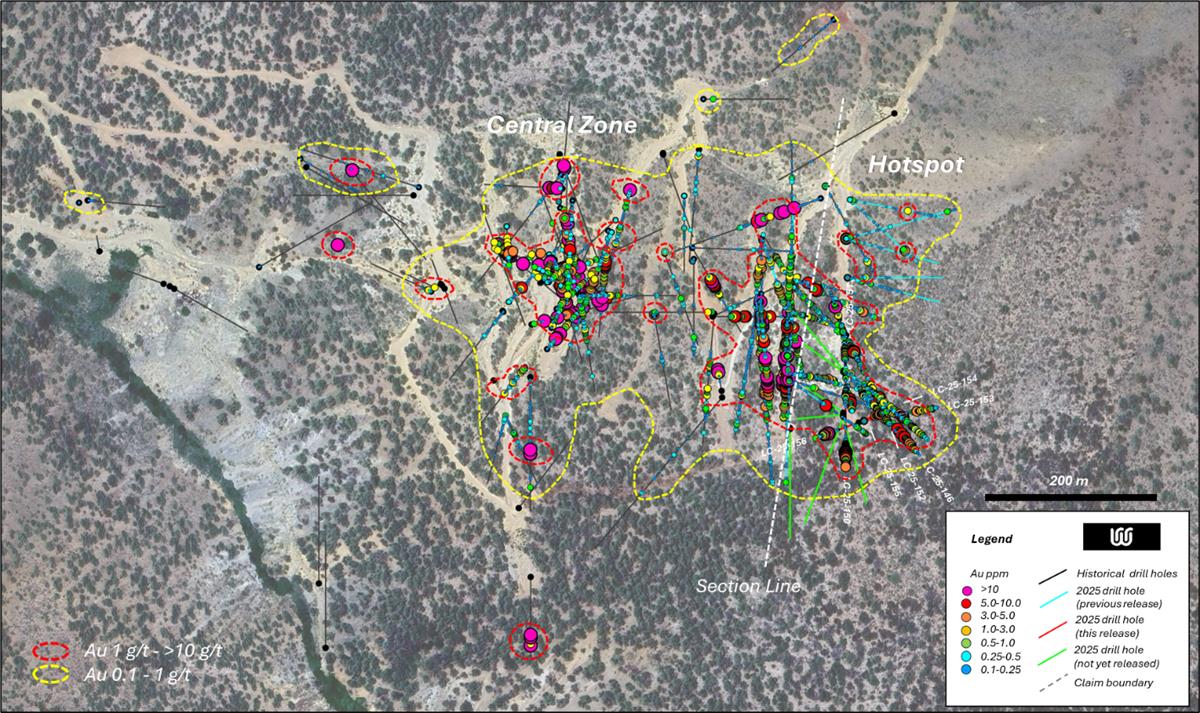
Figure 1. Plan map of the Lapon Gold deposit, showing the Central and Hotspot zones with historic and 2025 drilling results and contours for 0.1 – 1.0 g/t Au (yellow) and 1.0 – 10.0 g/t Au (red).
Click here to view image
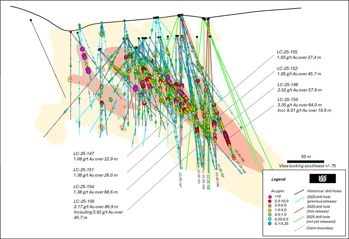
Figure 2. Cross-section of the Lapon Gold deposit at Hotspot, showing historic and 2025 drilling results with highlights of intervals from this release and contours for 0.1 – 1.0 g/t Au (yellow) and 1.0 – 10.0 g/t Au (red).
Michel David, Walker River’s President & CEO states: “We continue to be extremely encouraged by these new results which are confirming the potential and significantly increasing the gold mineralization at Lapon Canyon. As evidenced by the drill holes on the new upper road at Hotspot, returning significant gold values. Drilling is ongoing and we’re looking forward to additional results from Lapon Canyon and very excited with our ongoing interpretation of the gold mineralization at Lapon Canyon.”
On-going work at Lapon Canyon consists of data compilation, interpretation and resource modelling. Further drill results will be released as they become available. Field work and drilling is ongoing.
Results from previous and current (2025) drill programs, including the subsequent data compilation will enable the completion of an initial NI 43-101 compliant mineral resource on the Project.
Sampling Methodology, Chain of Custody, Quality Control and Quality Assurance
All sampling was conducted under the supervision of the Company's project geologists and the chain of custody from the drill to the sample preparation facility was continuously monitored. A blank or certified reference material was inserted approximately every tenth sample. The Lapon Canyon samples were delivered to American Assays Laboratories’ certified laboratory facilities in Sparks, NV. The samples were crushed, pulverized and the sample pulps digested and analyzed for gold using fire assay fusion and a 50 g gravimetric finish. Certain intensely altered samples used a 1 kg pulp screened to 100 microns. Duplicate assay on screen undersize. Assay of entire oversize fraction.
Samples are taken and bagged directly at the drill rig at every 1.5-meter interval, standard in the exploration industry. A small sample is also taken at the drill rig and put into a chip tray for examination purposes and to determine those sample bags that should be sent to the lab for assay purposes. Often this work is carried out using a microscope for the examination of the rock chips. The full sample bag from the interval chosen for assay purposes is then sent directly from the drill site to the lab, located in Sparks, NV.
The scientific and technical information contained in this news release has been reviewed, verified and approved by Dave Nuttall P.Geo, President of Geo Exploration, who is an independent Qualified Person as defined under NI 43-101 Standards of Disclosure for Mineral Projects.
About the Lapon Gold Project
The Lapon Gold Project consists of 147 claims (2940 acres) situated in the Wassuk Range, within Nevada’s Prolific Walker Lane shear zone, a 100 km wide structural corridor extending in a southeast direction from Reno, Nevada. The Lapon Gold Project includes Lapon Canyon, the Pikes Peak claims located 4 kilometres to the north, and the Rattlesnake and Range Front claims 3 kilometres to the west and over 600 meters lower than the present drilling at Lapon Canyon. The Lapon Canyon (96 claims) portion of the Project, is subject to an $5m USD exploration stream earn-in agreement with Nevada Canyon Gold Corp (news release 02-03-2025). The Project is easily accessible by secondary state roads from the main highway (25 kilometres), and is located approximately 60 kilometres southeast of Yerington, Nevada. A state power grid transmission line passes within three kilometres of the Project.
The Rattlesnake, Range Front, and Pikers Peak claims cover over 8 km of possible extensions of the range front zones to the west, north, and south of Lapon Canyon, adding several additional drill target areas to the project. Rattlesnake and Pikes Peak contain numerous historical mining and milling areas that consist of adits at different levels, shafts and underground workings, and a network of existing roads providing access throughout. Little or no exploration work has been carried out on these claims prior to Walker’s arrival. It is notable that the Rattlesnake area and adits are on strike with the Lapon Canyon discoveries located 3 km on strike and 600 meters above. Lapon Canyon hosts historical high grade gold mining with approximately 2000 feet of undergoing workings in three adits. Historical underground work returned numerous assay values in the one ounce per ton range, with a sample at the end of the A adit returning 20.6 ounces per ton Au. (NI 43-101, Montgomery and Barr, 2004).
FOR FURTHER INFORMATION PLEASE CONTACT:
Michel David, CEO & Director
Tel: 819 874-0030
Email: info@wrrgold.com
Website: www.wrrgold.com
Neither the TSX Venture Exchange nor its Regulation Service Provider (as that term is defined in the policies of the TSX Venture Exchange) accepts responsibility for the adequacy or accuracy of this release.
Cautionary Statements Regarding Forward Looking Information
This news release contains certain “forward-looking information” and “forward-looking statements” (collectively “forward-looking statements”) within the meaning of applicable securities legislation. All statements, other than statements of historical fact, included herein, are forward-looking statements. Forward-looking statements are frequently, but not always, identified by words such as “expects”, “anticipates”, “believes”, “intends”, “estimates”, “potential”, “possible”, and similar expressions, or statements that events, conditions, or results “will”, “may”, “could”, or “should” occur or be achieved There can be no assurance that such statements will prove to be accurate and actual results and future events could differ materially from those anticipated in such statements. Forward-looking statements reflect the beliefs, opinions and projections on the date the statements are made and are based upon a number of assumptions and estimates that, while considered reasonable by the Company, are inherently subject to significant business, economic, competitive, political, social and regulatory uncertainties and contingencies. Many factors, both known and unknown, could cause actual results, performance or achievements to be materially different from the results, performance or achievements that are or may be expressed or implied by such forward-looking statements and the parties have made assumptions and estimates based on or related to many of these factors. Such factors include, without limitation, the ability to complete proposed exploration work, the results of exploration, continued availability of capital, and changes in general economic, market and business conditions. Readers should not place undue reliance on the forward-looking statements and information contained in this news release concerning these items. The Company does not assume any obligation to update the forward-looking statements of beliefs, opinions, projections, or other factors, should they change, except as required by applicable securities laws. |


