Ruby Creek Project videos from August 2022 trip
Below are seven short videos I took while visiting the Ruby Creek Project back in late August 2022.
The panorama videos will give you a good general "lay of the land " of the terrain and an idea of the
size of the property. All of the videos were taken on the Ruby Creek Project property beyond the
bridge above the small dam at the start of Surprise Lake.
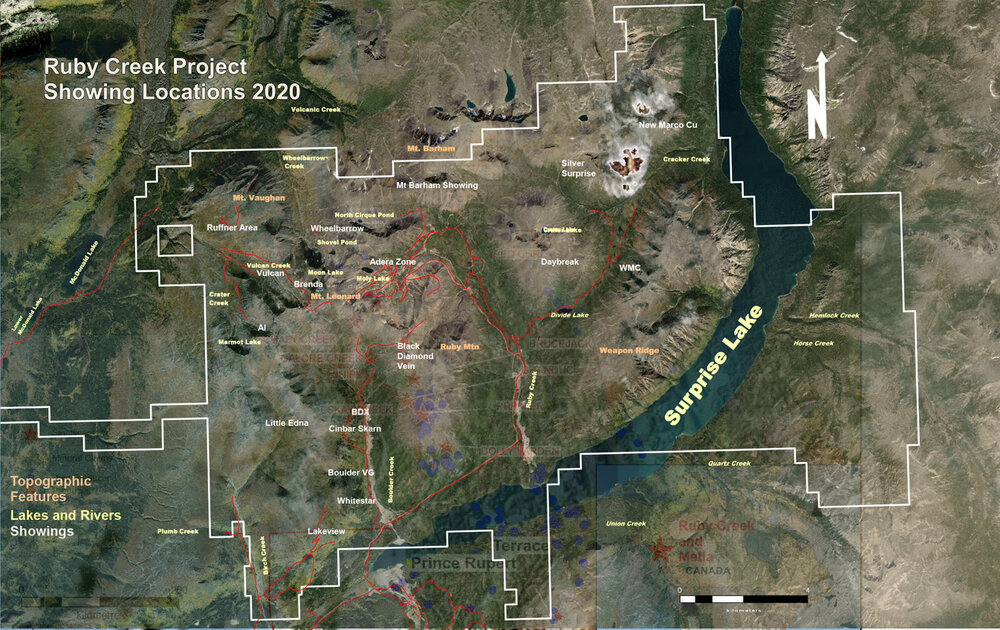
Refer to this diagram of the Ruby Creek Project taken from Stuhini Exploration webpages for an idea
of where the areas viewed in the videos are .
The first video is a view from the main Ruby Creek access road of one of the many former placer operations.
youtube.com
Second video gives you a good idea of the condition of the access road and surrounding terrain on
the way into the Ruby Creek Project past the bridge at the foot of Surprise Lake. I had no problems
driving my SUV up to the the working area of the Ruby Creek Project. The road is in as good a shape
as any unpaved country road.
youtube.com
Here's a view of the access road, in the distance, out to the 'Silver Surpise' area - 'Daybreak' is
the mountain that comes into view as the video pans to the left of the 'Silver Surprise' access road.
youtube.com
The next video begins at the gated entrance to the access road to the moly deposit. Panning to the
right you see the Ruby Flats area where most of the exploration drilling occurred this past summer.
The rise on the other side of Ruby Flats is 'Daybreak' and then stopping with a view of the road coming
into the project. Panning back down over Ruby Flats area again and then back up over the accesss
road to the moly deposit is (i think it is called) 'Thor Ridge' and the video ends with a view of
Ruby Mountain, one of the extinct volcanoes located on the Ruby Creek Project.
youtube.com
I took a stroll up one of the access paths between Ruby Mountain and Thor Ridge. It is more
or less the same scene as the previous video just from a higher elevation.
youtube.com
This video was taken approx 300 meters beyond the access gate on the road leading into the
moly deposit area. The drill rig seen down below on Ruby Flats was where the fourth hole was
being drilled. You also get a good idea of the well maintained access road into the moly deposit.
As you can see, the Ruby Flats terrain is very accessible and easy to get drilling equipment onto.
youtube.com
This final video shows the terrain surrounding the moly deposit where the western edge of the
resource begins about 300 meters in the distance. Panning along the North Range the video
then reaches to the west where the 'Silver Surprise' area comes into view, which is the distant
mountain area aout 7 km away, just to the left of "Daybreak". More of the Ruby Flats area is in
the foreground of the panoramic sweep which then continues on with a view of the south side
of Thor Ridge and the road access ending with another view of the moly deposit area. There
was quite a bit of rock lying all along the shoulders of the road from this point on towards the
moly deposit that showed visible moly and tungsten. I have a few rock souvenirs from this
area with visible moly and tungsten.
youtube.com
A special note of appreciation to the Stuhini crew that were present during my visit, especially
to chief geologist Ehsan Salmabadi, who took the time to show me around the property on my
first trip up to the Ruby Creek Project, and answered alot of questions I had about the exploration
potential of Ruby Creek. He drove a company leased 4 wheel drive vehicle with me over the moly
deposit right up to Moly Lake on that first excursion.
The above videos were taken a couple days later on my second trip onto the project.
The Ruby Creek Project has very good road access. The hiway leading back down into B.C from
the Trans-Alaskan Hiway in the Yukon provides the main access to the town of Atlin and is paved
for the entire distance. From the town of Atlin, Discovery Road is also paved up to the bridge over
the small dam at the start of Surprise Lake, where the Ruby Creek Project boundary starts.
Atlin B.C is about an 1 hour and 45 minute drive from Whitehorse Yukon. The town of Atlin is located
in one of the most scenic areas I have had the opportunity to visit. We travelled over 14,500 km
from Central Ontario during our drive out to Vancouver Island for a visit with family, before heading
north up to Atlin, taking the Stewart Cassiar hiway north on our way there.
GLTA !
|


