Where the !@#$% is Svalbard’s Weather Station?
Posted on May 13, 2010 by Anthony Watts
In the previous WUWT entry, Willis posted his data on the Svalbard weather station, noting that it is spliced data and that the station data has been merged in nearby station history:
0 km (*) Svalbard Luft 78.2 N 15.5 E 634010080002 rural area 1977–2006
47 km (*) Isfjord Radio 78.1 N 13.6 E 634010050010 rural area 1912–1980
425 km (*) Bjornoya 74.5 N 19.0 E 634010280003 rural area 1949–2006
Svalbard Luft is the airport. As we’ve noted time and again on WUWT, the stations in GHCN have a propensity for airport migration. Here’s what Svalbard Airport looks like to visitors:
Svalbard airport terminal and tarmac - Image from Wikimedia - click to enlarge
Lots of nice black asphalt and buildings there to absorb the feeble sunshine at that latitude. But where’s the weather station?
No help from NCDC’s metadatabase, they have no clue either, all they know is that it is “at the airport”:
The equipment tab gives no clues, and the lat/lon is too coarse to pinpoint a location within the airport complex.
But, the great thing about Svalbard is that it is now a tourist destination. Regular jet flights are available. Fortunately for us, tourists take photos, and upload them to Panoramio. Here’s one photo likely taken right off the plane:
Note the Stevenson Screen at the edge of the tarmac
Here are some additional views:
This photo is very high resolution, over 3000 pixels wide, see the zoomed section below
The zoomed image shows the Stevenson Screen at the edge of the tarmac

wattsupwiththat.files.wordpress.com
I found another tourist photo on Panaramio, that shows the characteristic metal legs and struts of the Stevenson Screen visible beyond the plane that tourists are boarding:
Note the legs and bracing struts of the Stevenson Screen are visible - click image for original photo
More tourist submitted Panoramio photos of the airport show just how much asphalt tarmac there is around the station, such as this one:
One tourist uploaded a huge panorama image of the airport tarmac - click for original image
And when you zoom in on that panorama image at far left, sure enough, there’s the Stevenson Screen again:

wattsupwiththat.files.wordpress.com
Stevenson Screen at the edge of the airport tarmac, zoomed subsection of previous image
It is clear that there’s a lot of asphalt around the station, but there’s also a lot of snow too. What happens when it snows at the airport? They clear the runway and tarmac, of course:
Svalbard Luft seen from the air - click for original image
Where’s the Stevenson Screen? Right at the edge of the tarmac.
Svalbard airport terminal and tarmac - Stevenson Screen location is approximately near the end of the arrow
So, aviation snow removal makes a nice black year round albedo, right next to the weather station. Plus jet exhaust, generators, steam driven de-icers and other tools of the aviation trade are also nearby. Even if the Stevenson Screen has been abandoned in favor of an automated sensor, as often happens at airports, both would still have some locally measured effects in the record.
In the Arctic and Antarctic, aviation is the lifeline of humanity. A warm pocket of energy use in a sea of snow and ice. It would be interesting to plant a few of my portable USB logging thermometers around Svalbard away from this pocket of humanity to see what sort or temperature readings we get. By bet is that we’ll see a local AHI (Airport Heat Island) at Svalbard. It’s a busy place. In 2009, the airport had 138,934 passengers. Source: ^ Avinor (2010). “Årsrapport Passasjerer” (in Norwegian). avinor.no.
In Willis’ previous essay, he notes RC calls it a 5 sigma outlier event in April 2006. I had surmised it might be due to a tarmac resurfacing changing the albedo. I could be right. From the Wiki article on Svalbard airport:
In 1989, parts of the runway were re-insulated, giving these areas that previously had been the worst an acceptable solution. In 2006, this measure was conducted on the remaining parts of the runway.
There was construction going on in 2006, Oddly the source of that metadata is from a paper on gauging the airport performance under the “duress” of climate change:
Svalbard airport runway. Performance during a climate-warming scenario. (PDF)
In a study initiated by the Norwegian Airport Authorities in 1995, insulation of the whole runway in a manner similar to the 1989 procedure was deemed the most favorable long-term runway maintenance strategy (Instanes, D. and Instanes, A., 1998). This has so far not been carried out, and a new reconstruction is planned for 2005/2006 to improve the runway. The average global surface temperature is projected to increase from 1.4 to 5.8°C between 1990 and 2100 (IPCC, 2001). Warming at higher latitudes of the Northern hemisphere may be greater than the global average, as high as 4 to 7°C between 2000 and 2100 (ACIA, 2004).
They don’t seem to realize anywhere in the paper that the temperature data they are relying of for input to their models used for permafrost thaw comes from the little white box at the edge of the tarmac. Talk about positive feedback and polar amplification. Let’s build a new runway; hey look it’s warmer we were right! Sheesh.
People like Jim Hansen and Gavin Schmidt who sit up at the top of the climate food chain and take data from these weather stations at face value and then use it to extrapolate to nearby grid cells because there are no other nearby stations in the Arctic really need to get out more and see what the measuring environment is like. Maybe somebody can convince them to get off their taxpayer funded butts and away from their computer screens someday and do some field work.
Of course given what they did to censure Willis at RC when he brought up the issues at Svalbard, I doubt they’d believe their own eyes if it contradicted their expectations.
UPDATE:
The UHI at Svalbard airport has been measured, using the driving technique I first wrote about back in fall 2008 to study UHI in Reno, NV. This study at:
climate4you.com
…was pointed out by commenter Ibrahim and is reproduced below
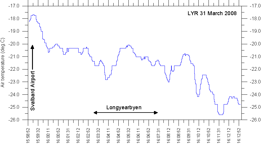
Longyearbyen UHI experiment, March 31, 2008
Longyearbyen March 31, 2008 16:15 PM (not corrected for summer time), looking WNW from the northern end of the lake Isdammen (see map below). The sky was almost clear, with a few local clouds forming over the fjord. The wind was weak from southeasterly direction, 0.5-3 m/s. The large building in the distance to the right is the main hangar at Svalbard Ariport. Compare with map below.
The general weather situation, measurement equipment and measurement route
The air temperature was about -20oC, and the wind weak from southeasterly direction, 0.5-3 m/s, but with local deviations (see map below). The sky was almost clear. The ground surface was covered by snow. The nearby fjord was ice free, with the exception of a 5-50 m wide zone with new icew along the coast. A thermistor was attached to the roof of a car (c. 1.5 m above terrain), and temperatures were logged at 2 sec. intervals. The time given in the diagrams below are not corrected for summer time. The measurements were carried starting at Svalbard Airport in the upper left of the map below, driving SE along the coast to the town, making a roundtour here, before proceding SE into the lower part of the major valley Adventdalen.
Longyearbyen is the worlds northernmost town and is located at 78o17'N 11o20'E, in central Spitsbergen . The present number of inhabitants is 2,001 (January 1, 2007). There is no official meteorological station located in Longyearbyen at the moment. The official meteorological station is located at the airport, about 4 km northwest of Longyearbyen, close to the coast (see map below).
Topographic map showing Longyearbyen and Svalbard Airport (Svalbard Lufthavn). The red line shows the measurement route March 31, 2008, starting at the Airport and ending in the lower part of the valley Adventdalen to the SE. In between, a detour was made in the central part of the town as shown. The wind was weak, 0.5-3 m/s, from south easterly direction, but with local deviations (blue arrows). The fjord was ice free. The map section measures c. 11 km west to east.
Results
climate4you.com
Result of temperature measurements along the route Svalbard Airport – Longyearbyen -Adventdalen, March 31, 2008. The official Svalbard meteorological station is located at the airport. Se map above for reference. Time (not corrected for summer time) is given in hh:min:ss format along the x-axis.
Interpretation of results
The whole area was snowcovered. The sun was below the skyline formed by the mountains, and albedo effects caused by buildings and roads for that reason presumably not very important.
The registered air temperatures show an overall falling trend towards SE along the main measurement route. Near the airport, where the official Svalbard meteorological station is located, air temperatures are relatively high (about -18oC), which is interpreted as the result of the onshore airflow from SE across the ice free fjord. Further towards SE, this local warming effect diminishes, and colder air (about -25oC) draining out of the valley Adventdalen dominates. The temperature difference between the Airport and Adventdalen is about 8oC, representing the open water effect (OWE) at this particular time. In between, the local heat island effect of the town Longyearbyen is only weakly developed. The maximum UHI effect appears to be about +0.5oC at the time of the experiment. The local cold trough recorded within Longyearbyen (16:04) corresponds to the position of the main valley axis, where cold air masses is draining NNE from the glacier at the valley head.
The existence of an urban heat island effect in a relatively small settlement as Longyearbyen may come as a surprise. This is, however, not the first time this has been observed in the Arctic; see, e.g., Hinkel et al. 2003.
wattsupwiththat.com |


