Not everything you think you know we think you think we know is wrong.
Mangled Jet Stream Delivers Record-Shattering Heat, Extreme Wildfires to California
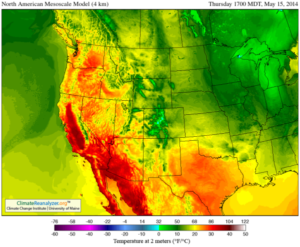
(GFS Model 40 hour forecast for May 15 shows 90 and 100 degree temperatures spreading across most of California. Image source: University of Maine. Data source: Global Forecast System Model/NOAA.)
It’s just mid-May, but a wave of record July-like heat and wildfires is building for California and the US West.
A high amplitude Jet Stream wave that has been in place over the US West for more than a year now has resulted in hot, dry conditions throughout this very long period. It is an ongoing insult that contributed to the worst California drought in more than 100 years. A set of weather anomalies that continues to leave California and the US Southwest very vulnerable to heatwaves, fires and amplifying droughts as summer continues to emerge.
The pattern is essentially stuck — featuring a hot, pole-reaching, wave of the Jet Stream continuously rising over the US West, Western Canada and Alaska, and diving deep into the Arctic. It is a condition climate researchers such as Dr. Jennifer Francis attribute to an ongoing erosion and degradation of Northern Hemisphere sea ice. And the predictions of Dr. Francis appear to have born out in both recent observations and cutting edge scientific research showing how sea ice loss has shoved the storm track away from California and the US Southwest (see how Climate Change Made the California Drought Worse).
In any case, it is highly unusual for such an intense Jet Stream pattern to remain fixed for so darn long.
Emerging El Nino Contributes to 100 Degree (F) Heat
In recent months, the strength of the heat flowing up through the Jet Stream wave has been intensified by a growing pool of anomalously warm water to the south in the Eastern Pacific. This gathering pool of intensifying heat is a signal for the coming of El Nino. Come winter, a strong El Nino might bring a radical and violent switch of California weather to much more rainy conditions. But, for now, it lends further energy to a gathering and extraordinary May heatwave for the US West Coast.
It is a flood of heat that is expected to bring 90 to 100 degree plus temperatures for a broad zone from southeast California to the coast and on northward through the Central Valley. And, already, the effect is being felt for some regions. Yesterday, Van Nuys Airport in Los Angeles shattered its previous record high temperature of 91 for the date as temperatures rocketed to 93 F. Today, the forecast is for 98. Tomorrow, 100. Friday 96.
This forecast is for a string of four consecutive all-time record highs during a period in which temperatures hit an extreme range of 18-25 F above the typical daily peaks of 75 for this time of year. Sacramento, meanwhile, is expected to tie the all-time high today at 100 F after reaching the same reading yesterday. Tomorrow’s forecast is for a scorching 101 F. Typical average highs for this time of year in Sacramento are around 80 F.

(Bernardo Fire approaches El Camino Drive, threatens homes in Carlsbad. Image source: Resident’s Contribution to ABC 10's Twitter Feed)
Santa Anna Winds, Heat, Drought Spur Large Fires
Rising Santa Anna winds in the range of 40 to 60 mph with maximum gusts as high as 87 mph in the San Diego Mountains combine with relative humidity values below 10% and extreme heat to create a high potential for wildfire outbreaks. As a result, red flag fire hazard warnings have been issued for a zone along California’s southwest coast and into the south-central valleys.
By Tuesday, two large fires — one in Bernardo, San Diego and a second in Miguelito, Santa Barbara — had already erupted and consumed hundreds of acres. The Bernardo fire, by early today, had rapidly expanded to cover more than 1,550 acres forcing the evacuation of over 20,000 people and 1,200 buildings. Three schools and one military base were also evacuated as fires raced through valleys to threaten expensive homes in developments on local ridges. As of late morning, the fire was only 25% contained.
The Bernardo fire, as of this writing, posed a severe threat to many highly populated areas forcing numerous evacuations and even the closing of El Camino Drive. Given conditions on the ground this is a very dangerous situation in which the fire may undergo rapid expansion. Up-to-the minute photos by local residents show rapidly deteriorating and dangerous conditions ( see ABC 10's live feed). People in the area should exercise extreme caution and pay close attention to local fire/weather bulletins.
The Miguelito fire, on the other hand, had grown to 600 acres in just one day as it threatened local ranches. Firefighters had, by late morning, managed to contain 50% percent of that blaze.
Conditions in Context
The most recent record heat spike is likely to only exacerbate current dire drought and fire issues for the state. Local reservoirs remain very low and various water rationing and restriction regimes have already been imposed in numerous districts. Atmospheric moisture levels are also very low resulting in little in the way of evaporative cooling once heating intensifies. The result is a high risk for continued record heat, drought, and fire as spring proceeds into summer.

(Mangled Jet Stream pattern on May 14, 2014 features numerous high amplitude Rossby Waves and hot-cool/east-west dipole patterns. High speed Jet Stream flow is more indicative of a winter pattern, possibly due to the retreat and temporary re-establishment of the polar vortex. But the huge propagation of east-west/hot-cool dipoles and the continued upper level air invasion of the northern polar zone point toward a highly disrupted Jet Stream. Image source: University of Maine.)
Though highly anomalous and extreme for early May, the most recent California heat spike is likely to abate by Friday and Saturday as an onshore wind flow and slight weakening of the ridge is expected to bring cooler conditions. Ongoing high amplitude Jet Stream waves, however, are expected to continue to propagate over the US West Coast with the ridge predicted to again re-strengthen later next week. The added heating of the atmosphere as spring progresses into summer is likely to further exaggerate this already extreme set of conditions. So the atmosphere is rigged for further record heat spikes and the potential for long periods of record or near-record conditions going forward.
UPDATE: By noon, Pacific time, the Bernardo Fire had expanded to 1680 acres and spawned two smaller fires in the San Diego region sending residents in Carlsbad and Poinsettia scrambling. It is difficult to express how dangerous this situation has become. Risk for severe intensification of these fires is very high due to extreme temperatures, humidity in the range of 6% in San Diego, and very strong Santa Anna winds.
UPDATE: Passenger photo by cGilbertRun of three fires plaguing San Diego from inbound airline Wednesday afternoon at 1 PM Pacific Time:

By early afternoon, the multiple blazes continued to expand spurring numerous additional evacuations, cutting off power to homes and businesses, and causing traffic snarls. Emergency authorities urged residents to remain at home or work unless ordered to evacuate to prevent congestion and to speed egress from affected areas.
UPDATE: By 1:30 PM PST, the Carlsbad Fire had spurred another 15,000 evacuations in San Diego. As of this time, the effect of the third fire is unknown.
UPDATE: Blaze near Poinsettia has resulted in an additional 11,000 evacuations. Sporadic reports coming in of three more fires now underway.
UPDATE: 30 homes reported burned in Carlsbad as of 2:00 PST. Unconfirmed reports of 103 F temperature readings in central San Diego.
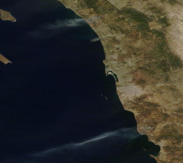
UPDATE: MODIS shot of fires burning in southwest California and northwest Mexico during satellite pass this afternoon:
UPDATE: Local elementary school apparently damaged in Carlsbad Fire.
UPDATE: Five of the six fires burning in San Diego include: The Carlsbad Fire, The Oceanside Fire, The Highway Fire in Fallbrook, The Camp Pendleton Fire, and the Bernardo Fire.
UPDATE: Seven fires now burning is San Diego. Six are shown on the map below which does not include the Bernardo Fire:

UPDATE: New fire reported in San Marcos, bring the total number of San Diego fires to 8.
UPDATE: Unconfirmed new fire near Black Mountain (5 PM PST). If confirmed, this brings the total to 9.
UPDATE: The San Marcos Fire has prompted yet one more major evacuation. Thousands of residents fled the fire only to get bogged down in gridlock near the blaze. Firefighters are now on the ground to protect San Marcos residences but air support appears delayed, possibly due multiple fires resulting in thinned resources.
robertscribbler.wordpress.com  |


