Nobody is taking an independent look.
Satellite Observation In 1977, Japan launched the first geostationary meteorological satellite (GMS) into geostationary orbit (about 36,000 km above the equator at a longitude of 140 degrees east) mainly to cover the western Pacific and East Asia as part of a space-based component of the Global Observation System (GOS) under the WMO World Weather Watch (WWW) programme. Since then, continuous efforts have been made to maintain and enhance the observational capabilities of meteorological satellites.
Satellite observation provides a wealth of information, including data on cloud height and distribution, upper-air wind, and sea surface temperature distribution. The observational data received from the spacecraft allow JMA and other National Meteorological and Hydrological Services (NMHSs) to continuously monitor significant meteorological phenomena such as typhoons, fronts and low-pressure systems. The data are also directly assimilated into the numerical weather prediction system, which in turn contributes to the timely issuance of disaster prevention information and weather forecasts from JMA and NMHSs.
Currently, the Multi-functional Transport Satellite (MTSAT-1R) launched in 2005 is in operation, performing observation every 30 minutes with imaging channels consisting of a visible band and four infrared bands. MTSAT-2 (launched in 2006 and currently in a state of standby in geostationary orbit) is scheduled to take over the imaging functions of MTSAT-1R in summer 2010. MTSAT-2 has the same imaging channels as MTSAT-1R, and will provide similar observation data. Along with information from MTSAT, JMA utilizes data from various polar orbiting satellites such as the NOAA series operated by the US, Metop operated by Europe, and earth observation satellites such as TRMM and AQUA. Data from these satellites are indispensable in observing typhoons, monitoring the global and marine environment and producing initial fields for numerical weather prediction. | 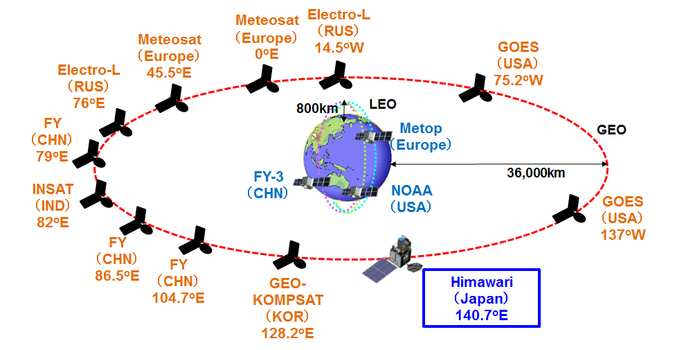
Current and planned space-based component of the Global Observation System
(picture from the WMO website)
jma.go.jp
=
The Argo program is a collaborative partnership of more than 30 nations from all continents (most shown on the graphic map in this article) to provide a seamless global array allowing any country to explore the ocean environment. Argo is a key component of the Global Ocean Observing System (GOOS). Argo is coordinated by the Argo Steering Team – an international body of scientists and technical experts that meets once per year. The Argo data stream is managed the Argo Data Management Team. Overall coordination is provided through the Argo Information Centre, an office belonging to the Intergovernmental Oceanographic Commission which also coordinates GOOS, and the World Meteorological Organization. Argo is also supported by GEO (the Group on Earth Observations), and has been endorsed since its early beginnings by the World Climate Research Programme’s CLIVAR Project (Variability and predictability of the ocean-atmosphere system), and by the Global Ocean Data Assimilation Experiment (GODAE OceanView).
en.wikipedia.org |
|


