Our endangered ice sheets:
A “sticky” jet stream is a meridional pattern
In a meridional pattern the jet stream will have highly amplified troughs and ridges. Low pressure systems tend to move faster (west to east) when associated with a zonal flow. A highly meridional flow can cause atmospheric blocking and spells of much below and much above normal temperatures.
http://www.theweatherprediction.com/habyhints/159/
When did the earth see a meridional pattern jet stream?
When the Wisconsin glaciation was taking place. The ‘Polar Vortex’ we have seen for the past couple of winters has the same shape as the Laurentide. Cold and lots of snow on the east coast but not on the west coast.

Position of the ice sheets in North America at 10,000 and 7,000 years before present.
[ Perhaps we should blame the human use of fire. ]
Europe area covered by ice

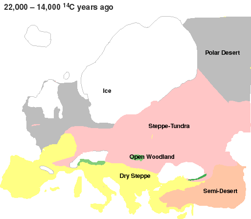
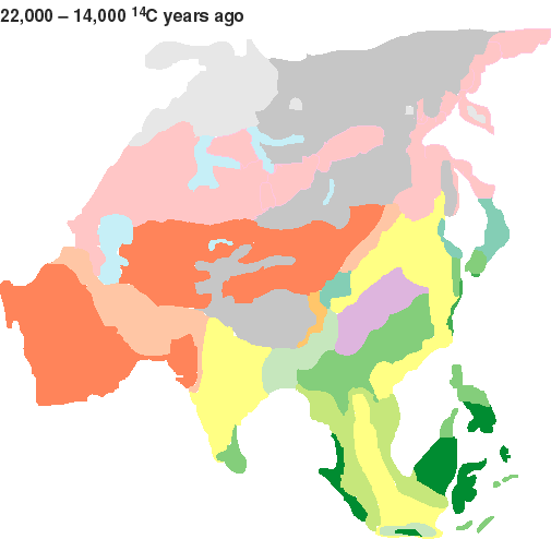
Eurasia during most extreme part of full glacial conditions (17,000-15,000 14C y.a.).

“This map concentrates on the time window slightly after the LGM, when aridity seems to have reached its most extreme point. Only slightly moister conditions prevailed for most of the period 22,000-14,000 14C y.a. (25,000-15,000 calendar years ago). A large area of extreme desert conditions existed across central Asia (dark red), surrounded by semi-desert (light red), under conditions much colder than the present-day. In the north, Siberia was colder and much more arid, with steppe-tundra (pink) and polar desert (grey). Ice masses (light grey) were present in north-western Siberia. In China, colder more arid conditions caused a retreat of forests, with grasslands (yellow) and open woodlands (medium green) in southern China and Japan. Forest steppe (violet) and conifer forest (blue green) may have predominated elsewhere. In south Asia, rainforest (darkest green) retreated and was replaced by grasslands (yellow) and monsoon forests and woodlands (lime-green). Scrub and open woodland (lighest green) probably existed in presently moist forest climates of Bangladesh and SW China.”
|