NexGen Energy (NXE-V) Intersects Massive Pitchblende 180m Southwest of Arrow
June 13, '16 - NR
NexGen Energy is pleased to announce further results from our ongoing spring drilling program on our 100% owned Rook I Property, Athabasca Basin, Saskatchewan.
Drilling at the area 180 m southwest of Arrow has intersected significant off-scale radioactivity associated with extensive visible uranium mineralization. All 3 holes in this area have intersected off-scale mineralization. A total of 11 drill holes have now encountered mineralization in this area, which remains open in all directions and has currently established a strike length of 76 m. Future drilling will be directed to determine whether this area which is 180 m southwest of Arrow, is connected to Arrow to the northeast, and the extent of the area further to the southwest.
Hole AR-16-90c3, which was drilled 74 m up-dip and southwest of hole AR-16-77c2 (see press release March 30, 2016) has intersected 8.05 m of total composite off-scale radioactivity (>10,000 to >61,000 cps) marked by dense accumulations of massive to semi-massive pitchblende within 68.0 m of total composite mineralization. Included as part of the 8.05 m of off-scale mineralization 1.5 m of minimum-greater-than-61,000 cps including 1.0 m that was continuous. This is the most significantly mineralized hole to date at this newly identified area.
In addition, a highly prospective alteration zone that is host to locally anomalous radioactivity has been identified 230 m below surface at this new area 180 m southwest of Arrow which represents a new target for further drilling (see within figure 2 "alteration zone"). The alteration zone is marked by intense dravite rich hydrothermal breccias which appear to be similar to those found in close proximity to the strong uranium mineralization in the higher grade sub-zone of the A2 shear. Significantly, the down-hole gamma probe survey completed after drilling AR-16-82c2 identified a 1.3 m long radiometric anomaly (2PGA-1000 model gamma probe) measuring greater than 1,000 cps to 26,132 cps within the alteration zone. Only weakly anomalous radioactivity was measured in the drill core with a handheld RS-120 scintillometer, which did not correspond to the strong down-hole radiometric anomaly. This was potentially a result of the wash out of mineralization within clay alteration. Further work is planned to explain this discrepancy.
Highlights:
180 m Southwest of Arrow:
AR-16-90c3 (74 m up-dip and southwest from AR-16-77c2) intersected 68.0 m of total composite mineralization including 8.05 m of total composite off-scale radioactivity (>10,000 – >61,000 cps) within a 125.0 m section (688.0 to 813.0 m).
AR-16-82c3 (52 m up-dip and northeast from AR-16-77c2) intersected 26.5 m of total composite mineralization including 3.8 m of total composite off-scale radioactivity (>10,000 – >61,000 cps) within a 205.0 m section (606.5 to 811.5 m).
AR-16-90c2 (39 m up-dip and southwest from AR-16-77c2) intersected 87.5 m of total composite mineralization of including 2.2 m of off-scale radioactivity (>10,000 - 52,000 cps) within a 212.0 m section (613.0 to 825.0 m) before the hole was terminated at 870 m.
Arrow, Activities & Financial:
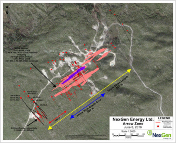
The land-based and basement hosted Arrow zone currently covers an area of 870 m by 280 m with a vertical extent of mineralization commencing from 100 m to 920 m, and remains open in most directions and at depth.
The spring 2016 program comprising 7,500 m of drilling continues with three drill rigs active. Concurrently, preparations are almost complete for a large summer drill program to begin in mid-to-late June.
The Company has cash on hand of approximately $100M upon closing of the previously announced financing with CEF Holdings.
A drill hole location map is presented in Figure 1, a schematic long section is shown in Figure 2, and core photos of high grade mineralization from drill hole AR-16-90c3 are shown in Figures 3 and 4.
Garrett Ainsworth, Vice-President, Exploration and Development, commented: "The intense alteration and dense massive to semi-massive mineralization encountered in drill holes AR-16-82c3 and -90c3 is analogous to the holes that signalled the beginning of the higher-grade A2 sub-zone. The structural analysis at this southwest zone supports the potential that it is an extension of the Arrow Deposit with potential for the presence of another high-grade zone."
Leigh Curyer, Chief Executive Officer, commented: "The area 180 m southwest of Arrow is developing quickly and significantly expanding the footprint of mineralization at Arrow. One of the objectives of the summer drilling program commencing in late June, will focus on this 180 m area southwest of Arrow in both directions along trend. We estimate a significant amount of drilling is required until the full extent of mineralization can determined."
Table 2: Arrow Deposit Drill Hole Data
Drill Hole
| Athabasca
Group -
Basement
Unconformity
Depth (m)
| Handheld Scintillometer Results (RS-120)
| Hole ID
| Azimuth
| Dip
| Total
Depth
(m)
| From (m)
| To (m)
| Width (m)
| CPS Range
| AR-16-82c2
| 140
| -75
| 873.00
| 93.00
| 243.50
| 244.50
| 1.00
| <500 - 620
| 608.00
| 609.50
| 1.50
| <500 - 2900
| 615.50
| 617.00
| 1.50
| <500 - 1500
| 619.50
| 620.00
| 0.50
| 530 - 3900
| 688.00
| 688.50
| 0.50
| <500 - 3900
| 698.00
| 698.50
| 0.50
| <500 - 950
| 709.50
| 717.50
| 8.00
| <500 - 1600
| 730.50
| 731.00
| 0.50
| <500 - 3500
| 741.50
| 742.00
| 0.50
| <500 - 5700
| 756.50
| 758.00
| 1.50
| <500 - 580
| 775.00
| 775.50
| 0.50
| <500 - 680
| 780.50
| 782.00
| 1.50
| <500 - 2300
| 821.50
| 824.00
| 2.50
| <500 - 1700
| 840.00
| 842.00
| 2.00
| <500 - 580
| 844.50
| 845.00
| 0.50
| <500 - 600
| AR-16-82c3
| 140
| -75
| 834.00
| 93.00
| 606.50
| 607.00
| 0.50
| <500 - 1700
| 637.50
| 638.50
| 1.00
| <500 - 2000
| 643.00
| 643.50
| 0.50
| <500 - 760
| 648.50
| 651.50
| 3.00
| <500 - 6000
| 663.00
| 664.00
| 1.00
| <500 - 9400
| 672.00
| 678.00
| 6.00
| <500 - 61000
| 711.00
| 711.50
| 0.50
| <500 - 2100
| 718.00
| 719.50
| 1.50
| <500 - 8400
| 724.00
| 726.00
| 2.00
| <500 - 30000
| 730.50
| 732.50
| 2.00
| <500 - 650
| 737.50
| 738.00
| 0.50
| 600 - 2000
| 752.50
| 758.00
| 5.50
| <500 - 53000
| 795.00
| 795.50
| 0.50
| <500 - 1000
| 809.50
| 811.50
| 2.00
| <500 - 2100
| AR-16-87
| 140
| -80
| 327.00
| N/A
| 224.50
| 227.00
| 2.50
| <500 - 730
| AR-16-88
| 140
| -80
| 291.00
| N/A
| No Anomalous Radioactivity
| AR-16-89
| 140
| -80
| 336.00
| N/A
| 277.50
| 278.00
| 0.50
| <500 - 520
| 282.00
| 285.00
| 3.00
| <500 - 1200
| AR-16-90c1
| 140
| -75
| 879.00
| N/A
| 699.00
| 699.50
| 0.50
| <500 - 970
| 725.00
| 725.50
| 0.50
| <500 - 550
| 728.00
| 732.00
| 4.00
| <500 - 2500
|
|
|
|
|
| 738.00
| 738.50
| 0.50
| <500 - 570
| 743.00
| 749.50
| 6.50
| <500 - 4700
| 785.50
| 792.50
| 7.00
| <500 - 4500
| 804.50
| 805.00
| 0.50
| <500 - 900
| AR-16-90c2
| 140
| -75
| 870.00
| N/A
| 613.00
| 616.00
| 3.00
| <500 - 20000
| 624.50
| 629.00
| 4.50
| <500 - 1350
| 632.50
| 647.00
| 14.50
| <500 - 22500
| 661.00
| 669.00
| 8.00
| <500 - 8300
| 676.50
| 687.50
| 11.00
| <500 - 8700
| 690.50
| 705.00
| 14.50
| <500 - 3600
| 709.50
| 716.50
| 7.00
| <500 - 1600
| 719.50
| 721.00
| 1.50
| 800 - 3500
| 726.00
| 728.50
| 2.50
| <500 - 800
| 735.50
| 737.00
| 1.50
| <500 - 2100
| 741.00
| 751.50
| 10.50
| <500 - 21000
| 762.50
| 763.50
| 1.00
| <500 - 800
| 774.00
| 777.00
| 3.00
| 530 - 52000
| 801.00
| 801.50
| 0.50
| 550 - 7400
| 808.50
| 811.00
| 2.50
| <500 - 1000
| 816.00
| 816.50
| 0.50
| <500 - 520
| 823.50
| 825.00
| 1.50
| <500 - 3000
| AR-16-90c3
| 140
| -75
| 921.00
| N/A
| 688.00
| 691.50
| 3.50
| <500 - 1300
| 698.00
| 698.50
| 0.50
| <500 - 650
| 702.50
| 723.50
| 21.00
| <500 - >61000
| 731.00
| 739.50
| 8.50
| <500 - 22000
| 744.00
| 756.00
| 12.00
| <500 - 16000
| 759.00
| 763.00
| 4.00
| <500 - 1200
| 769.50
| 776.50
| 7.00
| <500 - 3700
| 786.50
| 793.00
| 6.50
| <500 - 1750
| 808.00
| 813.00
| 5.00
| <500 - 2400
|
Parameters:
Maximum internal dilution 2.00 m downhole
All depths and intervals are meters downhole
"Anomalous" means >500 cps (counts per second) total count gamma readings by gamma scintillometer type RS-120
"Off-scale" means >10,000 cps (counts per second) total count gamma readings by gamma scintillometer type RS-120
Where "Min cps" is <500 cps, this refers to local low radiometric zones within the overall radioactive interval
Natural gamma radiation in drill core reported in this news release was measured in counts per second (cps) using a Radiation Solutions Inc. RS-120 gamma-ray scintillometer. The reader is cautioned that total count gamma readings may not be directly or uniformly related to uranium grades of the rock sample measured; they should be used only as a preliminary indication of the presence of radioactive minerals. All intersections are downhole. True thicknesses are yet to be determined.
Split core samples will be taken systematically, and intervals will be submitted to SRC Geoanalytical Laboratories (an SCC ISO/IEC 17025: 2005 Accredited Facility) of Saskatoon for analysis. All samples sent to SRC will be analyzed using ICP-MS for trace elements on partial and total digestions, ICP-OES for major and minor elements on a total digestion, and fusion solution of boron by ICP-OES. Mineralized samples are analyzed for U3O8 by ICP-OES and select samples for gold by fire assay. Assay results will be released when received and after stringent internal QA/QC protocols are passed.
The technical information in this news release has been approved by Garrett Ainsworth, P.Geo., Vice President – Exploration & Development, a qualified person for the purposes of National Instrument 43- 101 – Standards of Disclosure for Mineral Projects. Mr. Ainsworth reviewed the data disclosed in this news release, including the sampling, analytical and test data underlying the information contained in this news release.
The mineral resource at the Arrow Deposit was completed by RPA Inc. and has an effective date of January 14, 2016. The mineral resource is reported at a cut-off grade of 0.25% U3O8. The cut-off is based on a long-term uranium price of USD$65/lb U3O8. The mineral resource is classified into the inferred category based on the CIM Definition Standards. For details regarding the geology and mineralization of the Arrow Deposit, the drilling, sampling and analytical procedures followed and the estimation methodology used in the preparation of the mineral resources, please refer to the Company's Amended and Restated News Release dated March 3, 2016, which is available under the Company's profile on the SEDAR website at www.sedar.com.
ARROW DEPOSIT DRILLING
AR-16-82c2
Hole AR-16-82c2 was a directional hole that departed pilot hole AR-16-82c1 at 162 m. It tested the A4 shear 35 m up-dip and northeast of AR-16-77c2 (2.3 m of off-scale radioactivity in the A4 shear; assays pending). Directional drilling was initiated at 286 m and the A4 shear was intersected at an inclination of -73°.
Basement lithologies were intersected beginning at the top of the hole and consisted largely of semipelitic gneiss to granofel, with relatively narrow intervals of pelitic gneiss and mylonite (the A2 through A4 shears). The hole successfully intersected anomalous radioactivity in the A4 shear and to the southeast of the A4 shear that was associated with locally disseminated and fracture controlled pitchblende mineralization. A total composite mineralization of 23.0 m was intersected within a 601.5 m section (243.5 to 845.0 m) before the hole was terminated at 873 m. Of important note, an extensive zone of hydrothermal alteration marked by intermittent dravite breccias and strong clay-chlorite alteration was intersected between 195 and 275 m. This style of alteration is equivalent to what has been observed immediately adjacent to high-grade uranium mineralization in the area of the A2 higher grade sub-zone at Arrow.
AR-16-82c3
Hole AR-16-82c3 was a directional hole that departed pilot hole AR-16-82c2 at 297 m. It tested the A4 shear 52 m up-dip and northeast of AR-16-77c2. Directional drilling was initiated at 309 m and the A4 shear was intersected at an inclination of -70°.
Basement lithologies were intersected beginning at the top of the hole and consisted largely of semipelitic gneiss to granofel, with relatively narrow intervals of pelitic gneiss and mylonite (the A2 through A4 shears). The hole successfully intersected anomalous radioactivity in the A4 shear and to the southeast of the A4 shear that was associated with stringers, disseminated and fracture controlled pitchblende mineralization. A total composite mineralization of 26.5 m including 3.8 m of off-scale radioactivity (>10,000 to >61,000 cps) was intersected within a 205.0 m section (606.5 to 811.5 m) before the hole was terminated at 855 m.
AR-16-87
Hole AR-16-87 was collared from surface at a steeply angled orientation (-80°) to the southeast (140°). It was designed to both test the area of the unconformity and the projection of the shallow, extensive and highly prospective dravite - clay - chlorite breccia style alteration intersected in hole AR-16-82c2.
Basement lithologies were intersected beginning at 93.9 m and consisted largely of semipelitic gneiss. No Athabasca Group sandstones were intersected. Intermittent weak to strong hematite, chlorite and clay alteration was intersected throughout the basement. A total composite mineralization of 2.5 m was intersected between 224.5 and 227.0 m. The hole was terminated at 327 m.
AR-16-88
Hole AR-16-88 was collared from surface at a steeply angled orientation (-80°) to the southeast (140°). It was designed to both test the area of the unconformity and the projection of the shallow, extensive and highly prospective dravite - clay - chlorite breccia style alteration intersected in hole AR-16-82c2.
Basement lithologies were intersected beginning at 95.7 m and consisted largely of intrusive gneiss. No Athabasca Group sandstones were intersected. Intermittent weak to strong hematite, chlorite and clay alteration was intersected throughout the basement. No anomalous radioactivity was encountered before the hole was terminated at 291 m.
AR-16-89
Hole AR-16-89 was collared from surface at a steeply angled orientation (-80°) to the southeast (140°). It was designed to both test the area of the unconformity and the projection of the shallow, extensive and highly prospective dravite - clay - chlorite breccia style alteration intersected in hole AR-16-82c2.
Basement lithologies were intersected beginning at 94.1 m and consisted largely of semipeltic gneiss. No Athabasca Group sandstones were intersected. Widespread and highly prospective dravite alteration was intersected between 99.2 and 285.0 m. A total composite mineralization of 3.5 m was intersected within a 7.5 m section (277.5 to 285.0 m) before the hole was terminated at 336 m.
AR-16-90c1
Hole AR-16-90c1 was a directional hole collared from surface at an angled orientation (-75°) to the southeast (140° azimuth). It tested the A4 shear 50 m down-dip and to the southwest from AR-16-77c2. Directional drilling was initiated at 126 m and the A4 shear was intersected at an angle of -76°.
Basement lithologies were intersected beginning at 94.2 m and consisted largely of semipelitic gneiss to granofel, intrusive gneiss and relatively narrow intervals of pelitic gneiss and mylonite (the A2 through A4 shears). No Athabasca Group sandstones were intersected. The hole successfully intersected anomalous radioactivity in the A4 shear that was associated with disseminated and fracture-hosted pitchblende mineralization. A total composite mineralization of 19.5 m was intersected within a 106.0 m section (699.0 to 805.0 m) before the hole was terminated at 879 m.
AR-16-90c2
Hole AR-16-90c2 was a directional hole that departed pilot hole AR-16-90c1 at a depth of 349 m. It tested the A4 shear 39 m up-dip and southwest of AR-16-77c2. Directional drilling was initiated at 381 m and the A4 shear was intersected at an inclination of -69°.
Basement lithologies were intersected beginning at the top of the hole and consisted largely of semipelitic gneiss to granofel, with relatively narrow intervals of pelitic gneiss and mylonite (the A2 through A4 shears). The hole successfully intersected anomalous radioactivity in the A4 shear and to the southeast of the A4 shear that was associated with stringers, disseminated and fracture controlled pitchblende mineralization. A total composite mineralization of 87.5 m including 2.2 m of off-scale radioactivity (>10,000 to 52,000 cps) was intersected within a 212.0 m section (613.0 to 825.0 m) before the hole was terminated at 870 m.
AR-16-90c3
Hole AR-16-90c3 was a directional hole that departed pilot hole AR-16-90c2 at a depth of 387 m. It tested the A4 shear 74 m up-dip and southwest of AR-16-77c2. Directional drilling was initiated at 399 m and the A4 shear was intersected at an inclination of -69°.
Basement lithologies were intersected beginning at the top of the hole and consisted largely of semipelitic gneiss to granofel, with relatively narrow intervals of pelitic gneiss and mylonite (the A2 through A4 shears). The hole successfully intersected anomalous radioactivity along strike from the A4 shear and to the southeast of the A4 shear that was associated with semi-massive to massive veins, breccias, stringers and disseminated pitchblende. A total composite mineralization of 68.0 m including 8.05 m of off-scale radioactivity (>10,000 to >61,000 cps) was intersected within a 125.0 m section (688.0 to 813.0 m) before the hole was terminated at 921 m. AR-16-90c3 represents the discovery of a significant high grade mineralization 180 m southwest of Arrow.
About NexGen
NexGen is a British Columbia corporation with a focus on the acquisition, exploration and development of Canadian uranium projects. NexGen has a highly experienced team of uranium industry professionals with a successful track record in the discovery of uranium deposits and in developing projects through discovery to production.
NexGen owns a portfolio of highly prospective uranium exploration assets in the Athabasca Basin, Saskatchewan, Canada, including a 100% interest in Rook I, location of the Arrow Discovery in February 2014. The Arrow Deposit's maiden Inferred mineral resource estimate is 201.9 M lbs U3O8 contained in 3.48 M tonnes grading 2.63% U3O8. Rook I also hosts the Bow Discovery which is 3.7 km along trend and northeast of Arrow and was made in March 2015.
SOURCE NexGen Energy Ltd.
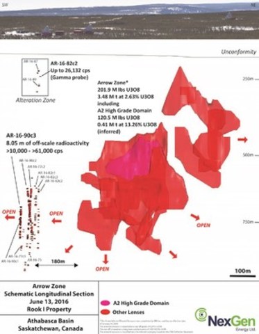
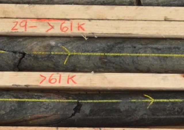
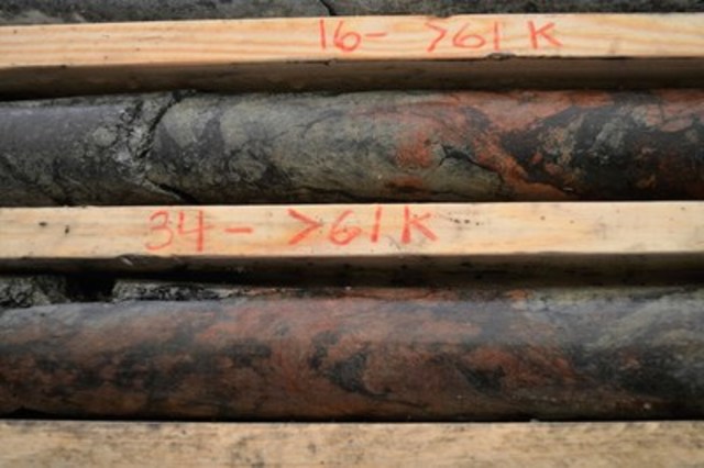
Image with caption: "Figure 1: Arrow Drill Hole Locations (CNW Group/NexGen Energy Ltd.)". Image available at: http://photos.newswire.ca/images/download/20160613_C3575_PHOTO_EN_711728.jpg
Image with caption: "Figure 2: Schematic Long Section of the Arrow Deposit and the Area 180 m Southwest of Arrow (CNW Group/NexGen Energy Ltd.)". Image available at: http://photos.newswire.ca/images/download/20160613_C3575_PHOTO_EN_711730.jpg
Image with caption: "Figure 3: AR-16-90c3 (Massive to Semi-Massive Mineralization) (CNW Group/NexGen Energy Ltd.)". Image available at: http://photos.newswire.ca/images/download/20160613_C3575_PHOTO_EN_711732.jpg
Image with caption: "Figure 4: AR-16-90c3 (Semi-Massive Mineralization) (CNW Group/NexGen Energy Ltd.)". Image available at: http://photos.newswire.ca/images/download/20160613_C3575_PHOTO_EN_711734.jpg

Leigh Curyer, Chief Executive Officer,
NexGen Energy Ltd.,
+1 604 428 4112,
lcuryer@nexgenenergy.ca ,
www.nexgenenergy.ca ;
Travis McPherson, Corporate Development Manager,
NexGen Energy Ltd.,
+1 604 428 4112,
tmcpherson@nexgenenergy.ca ,
nexgenenergy.ca |


