In related news, The Boy might be coming back.
So Long, La Niña; Arctic Temperatures Soar 63°F in 24 Hours
By: Jeff Masters , 5:15 PM GMT on February 09, 2017
So Long, La Niña; Arctic Temperatures Soar 63°F in 24 Hours
In its latest monthly advisory, issued Thursday, NOAA’s Climate Prediction Center (CPC) sounded the death knell for the 2016-17 La Niña. SSTs in the benchmark Niño 3.4 region (in the equatorial Pacific) warmed to 0.3°C below average during early February; SSTs of 0.5°C or more below average in this region are required to be classified as weak La Niña conditions. As further evidence of the demise of La Niña, subsurface cold waters across the equatorial Pacific have completely vanished, and much warmer-than-average waters built off the coast of Peru in late January and early February, bringing unusual El Niño-like flooding rains to that nation. The 2016 - 2017 La Niña event was one of the weakest and shorted-lived La Niñas on record, lasting just six months and peaking with sea surface temperatures (SSTs) in the Niño3.4 region of 0.8° below average. According to CPC, only one other La Niña since 1950 has been this short and weak: the 1967 - 1968 event, which lasted five months, and also peaked at SSTs of 0.8°C below average in the Niño 3.4 region.
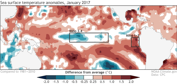
Figure 1. Average sea surface temperatures during January 2017, shown as departure from the long-term (1981-2010) average. Weak La Niña conditions were present in the Niño 3.4 region, but the waters were growing unusually warm along the coast of Peru in the Niño 1+2 region. Climate.gov figure from CPC data.
The forecast: Neutral this summer, then El Niño this fall?
In a Thursday ENSO Blog entry, NOAA/CPC’s Emily Becker reviews the El Niño forecast for the rest of 2017. Most computer models agree that neutral conditions will continue into the summer, and forecasters estimate an approximately 60% chance of neutral conditions lasting through the spring. After that, it gets complicated. We have a very difficult time predicting the future beyond the March–May period: the so-called spring predictability barrier. “In fact, a forecast made in June for the sea surface temperature in December (six months away) can be more successful than a forecast made in February for May (three months away)!” Becker relates. Some of the computer models are calling for a return of El Niño conditions by the second half of 2017. CPC’s current consensus forecast for the September—November 2017 period estimates a 12% chance of La Niña conditions, 40% chance of neutral conditions, and a 48% chance of El Niño. The latest Australian Bureau of Meteorology models are more aggressive about El Niño, showing development by this spring. If El Niño materializes in 2017, it would give us an unusual three-year series of El Niño/La Niña/El Niño: something that has only happened once since 1950—in 1963/1964/1965.
wunderground.com |


