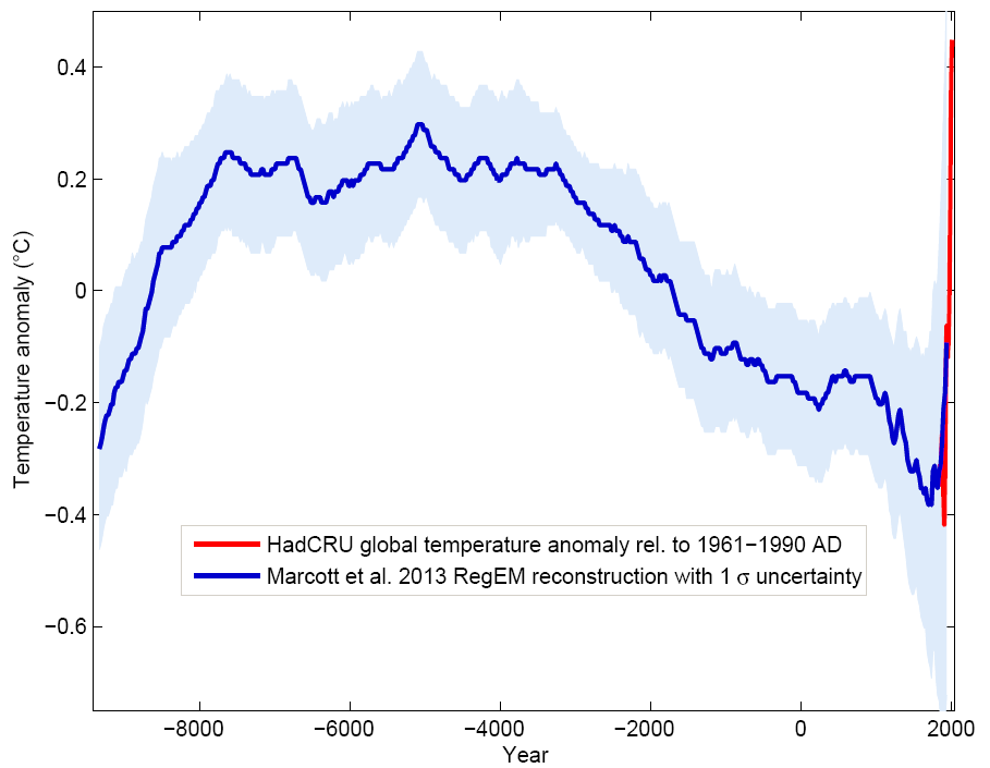
"it's been warmer than now in the past 10K years "
"I can say I believe we have not crossed any climate tipping point."
I think we've crossed several; permafrost melting with methane release, and arctic ice cover.
=
Lowest maximum on record (again)
After a drop of almost 262 thousand km2 in just three days, it looks highly likely that the maximum for sea ice extent was reached two weeks ago, according to the data provided by JAXA, the Japan Aerospace Exploration Agency (via ADS-NiPR ; it used to be provided by IJIS).
It's a new lowest maximum record, and the third time in a row that extent stayed below the 14 million km2 mark. The previous lowest max on record was reached in 2015 (13.942 million km2), almost beaten last year (13.959 million km2), but this year SIE went lower still and peaked at 13.878 million km2.
This graph by commenter Deeenngee, posted on the Arctic Sea Ice Forum, visualizes maximums from the past and the trajectory to this year's max:

It looks highly likely that the max has been reached for NSIDC daily SIE as well (graph provided by Jim Hunt from the Great White Con blog), a third record low in a row if my eyes don't deceive me:

The drops are mostly driven by sea ice reductions in the Bering and Okhotsk Seas, but will soon be joined by drops on the Atlantic side of the Arctic as well, as the ice is pretty thin there, according to the Uni Bremen SMOS thin sea ice map.
Given the wind forecast, I also expect further sea ice retreat from the southern shores of Novaya Zemlya (similar to what happened in 2011 and 2012):
 It looks highly unlikely that there will be a sudden surge of sea ice growth at the edges given the current GFS temperature anomaly forecast for the coming week (as provided by the Climate Change Institute at the University of Maine): It looks highly unlikely that there will be a sudden surge of sea ice growth at the edges given the current GFS temperature anomaly forecast for the coming week (as provided by the Climate Change Institute at the University of Maine):  An anomaly of 5 °C is pretty high, although it doesn't mean temperatures will be going above zero. But it's close, and given the fact that these temps will be accompanied by clouds over the Barentsz and Kara seas, melt onset is likely in these regions, which will make them extra vulnerable once the melting season gets going for real. An anomaly of 5 °C is pretty high, although it doesn't mean temperatures will be going above zero. But it's close, and given the fact that these temps will be accompanied by clouds over the Barentsz and Kara seas, melt onset is likely in these regions, which will make them extra vulnerable once the melting season gets going for real.
Needless to say, SIE is currently lowest on record (graph created by Jim Pettit):

My guess is it will stay lowest for a while, but it remains to be seen if it will go as crazy low as last year (green line). Either way, it seems the melting season will be off to a flying start again.
neven1.typepad.com |


