Well, we need to spread this stuff out. Currently raining gently, water in the street down the block is receding slowly.
Matt Corbett has some educational stuff about the area drainage issues:
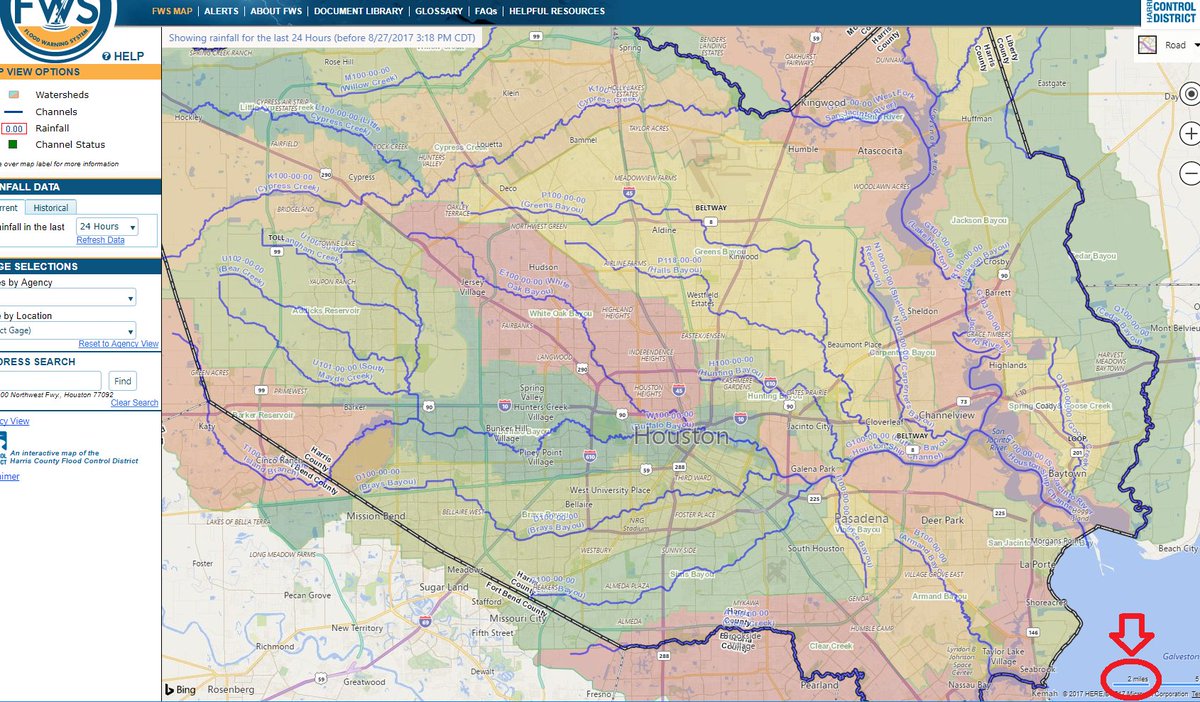
Houston is on a flat, mostly featureless plain, which is naturally drained by a number of Bayous ("The Bayou City" refers to HTX, not NOLA)
Matt Corbett? @CorbettMatt Aug 27
which all run (and drain) from west to east, converging on either the ship channel or San Jacinto Bay
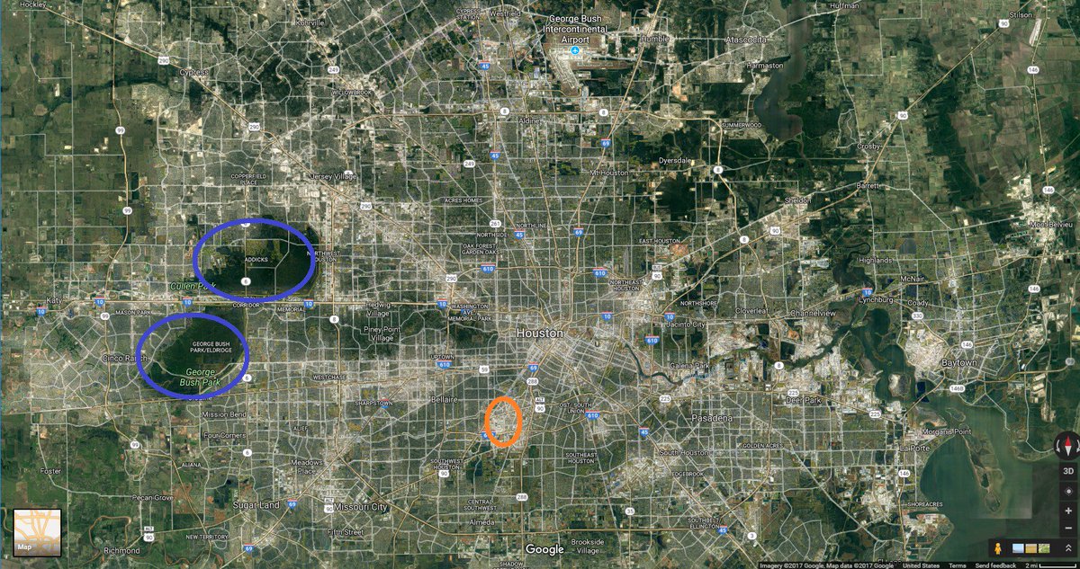
(Note: I've highlighted 2 areas- Addicks & Barker reservoirs and the medical center, because I'll mention them later)
HTX has sandy [ Mostly CLAY, not sand. ] soil and a high water table, and so has some, but limited, ability to rely on absorption
(related: No houses have basements and it would be nearly impossible to construct a subway)
Most of HTX is ~35-45' above sea level. Flooding risk is almost entirely from rain, not storm surges
Being Gulf Coast, HTX gets ~50" of rain a year. Gulf T-Storms can get intense. 4-6"-in-8-hours storms happen about once a year
flooding is essentially a rate problem- can you drain the water as fast as it comes?
when the answer is 'no', water backs up along the drainage routes

as a result, any person's flooding risk is mainly about proximity and elevation vs the nearest bayou
The primary backup for the bayous for handling too much water are the roads
In the 90s. Houston was getting large enough that relying on groundwater was starting to cause subsidence problems
The powers that be decided (wisely, mostly) to slowly convert all the roads into a giant rain collection network
so every time an asphalt road needed to be repaved, it got replaced with curb & gutter concrete w/ big storm sewer underneath
usually means that in flooding situations, roads briefly become rivers and then drain, saving houses from flood damage
but it's also a work in progress that has proceeded at the rate roads needed replacing, and varies greatly by location
the next backup for water are sections of freeways.
Thus, flood control in HTX is and has been in a continual state of upgrade for 20 years
However HTX has also been growing rapidly in that time, adding about 100-125k people/year for 15 years
with the result that at any given time the flood control has been adequate, but for the city T-5 years ago, not now
with the currently least-adequate parts usually around the geographic periphery and immediately downstream
The key incidents forming city officials' decision making have been the experiences of Allison (2001), Rita (2005), Ike (2008) and the flooding events of the past 2 years (Memorial Day 2015 and Tax Day 2016)
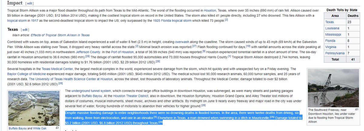
Conceptually, Harvey is closest to Allison, which was a TS that parked itself over HTX for 3 days and dumped 20" rain
-----------------------------------
Addicks and Barker Dams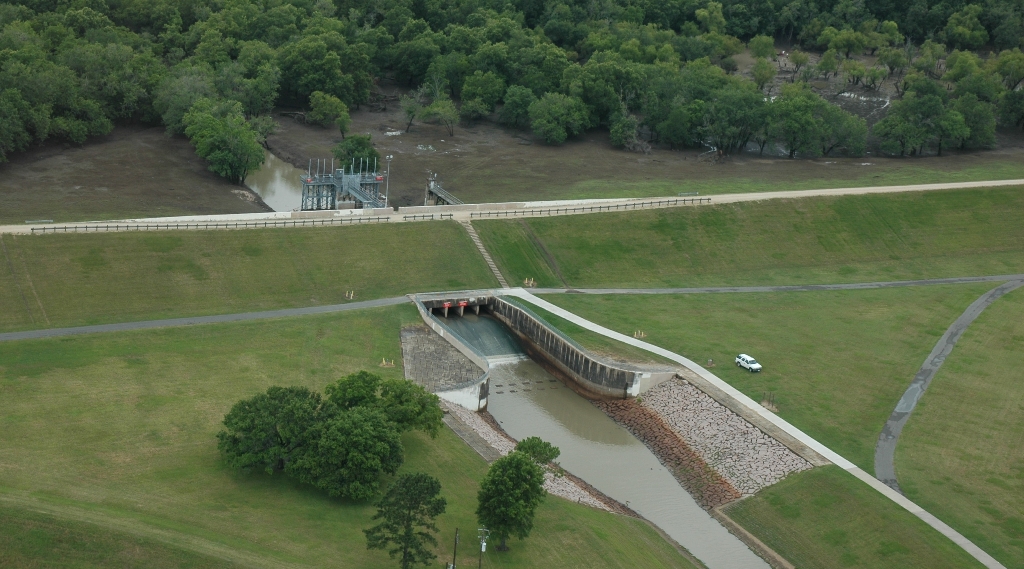
More than a half century ago, in response to devastating floods that occurred in Houston in 1929 and 1935, the U.S. Army Corps of Engineers began construction of Addicks and Barker Dams in what was then undeveloped areas in far west Harris and east Fort Bend counties. This undertaking was a milestone in a longstanding partnership between the Corps and the greater Houston community.
Addicks and Barker reservoirs are located near the intersection of I-10 and State Highway 6, in an area considered to be in the upper watershed of Buffalo Bayou. They provide flood damage reduction along Buffalo Bayou downstream of the reservoirs and through the center of the City of Houston. But like much of our national infrastructure, Addicks and Barker have been around a long time. The Corps continually inspects all of its dams nationwide under its Dam Safety Program, a program that shows our commitment to protecting lives, property and the environment by ensuring that all dams are designed, constructed, operated and maintained as safely and effectively as possible. The Corps' Dam Safety Program provides a framework to ensure that both short and long term solutions are studied and applied and helps to ensure public safety for our local communities.
swg.usace.army.mil
They're having to release water from these two big reservoirs which drain into Buffalo Bayou, the big bayou that runs through the center of Houston. If they don't release it, it will go around the reservoirs and flood MORE areas. These two reservoirs are north and south of I10 out west of Houston or in west Houston. Most of the time, they're a big green area with bike and hiking and horse trails, ball fields, picnic areas, playgrounds. But when heavy rains come, they're closed and fill up with water.
They're also releasing water from Lake Conroe into the San Jacinto river (west branch) for the same reasons. This is the only release that can indirectly impact our area. It's not upstream from us but Cypress and Spring Creeks drain into the San Jacinto so if you fill it up more, the ability to take our runoff is more limited.
|


