Not in Dec.
-
Worsening Weather to Feed Monstrous Thomas Fire Through Sunday
It shouldn’t be happening in typically wetter, cooler December. But, due to human-forced climate change, it is.
The Thomas Fire, at 242,000 acres, is now the fourth largest fire in California history. Alone, it has destroyed 900 structures — a decent town’s worth gone up in smoke. And today it threatens pretty much all of Santa Barbara’s 62,000 buildings. For future days promise conditions that could expand the monstrous blaze into the largest fire ever seen for the state.
(Persistent western ridge formation is an expected upshot of sea ice retreat in the Arctic. A feature that will result in a drier, warmer, more fire prone California if the trend toward sea ice melt and global warming continues.)
Firefighters battling the blaze have faced insane odds to manage a herculean feat — achieving 35 percent containment as blowtorch like Santa Ana winds consistently billowed through the region over the past two weeks. These winds have been both abnormally strong and persistent. And they’re run over dry lands through a season that is typically known for its more prevalent rainfall — not the expanding drought we see today.
Given these presently very abnormal conditions, fire officials don’t expect to achieve full 100 percent containment for three more weeks. And that’s with over 8,144 firefighters on the ground assisted by 1,004 fire engines and 27 helicopters.
(The 2012 to 2017 California drought was slaked by rains last winter. However, it appears to have returned in force with southern portions of the state again facing an extended dry period.)
Present weather conditions for California are extraordinary. A persistent ridge of high pressure has hovered over the region. And this high has helped to spike local temperatures, speed a re-emergence of drought, and drive very powerful Santa Ana winds through the region. The high formed as sea ice advance in the Chukchi and Bering Seas far to the north lagged. Open water that is usually ice covered at this time of year radiated more heat into the local atmosphere — providing a slot of warmer air that assisted this drought, heat, and wind-promoting high pressure ridge in forming.
The intensity of these highs, influenced by climate change, out west has consistently risen into the 1040+ hPa range. Highs that have been juxtapposed by a strong low further south near Mexico. And a steep pressure gradient between these two persistent weather systems has helped to drive the very strong, fire-fanning, Santa Ana winds through the region. As the Thomas Fire blossomed last week, fire conditions achieved extremes never before seen in state history as those hot, dry winds roared over hills and through valleys.
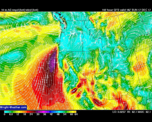
(GFS model runs show the fire fanning Santa Ana winds strengthening through Sunday. Hat tip to Dan Leonard.)
Unfortunately, weather models for the next few days show this Santa Ana wind producing pressure gradient either persisting or strengthening. Today, this gradient is producing winds with gusts of up to 55 mph. By Sunday, the high over the Pacific is predicted to face off against a low over Northwestern Mexico. And the gradient between these two systems may further intensify these fire fanning winds. Wind speed and fire hazard are not expected to be as extreme as last week. But the re-intensifying winds will do firefighters no favors.
In addition, and perhaps more importantly to the long range picture, there is not even a hint of rain in the forecast through at least the next week. Dry, warmer than normal weather is expected to remain in place at least through that period. And hope for wetter, cooler weather has only begun to emerge in the longer range, less certain forecast.
robertscribbler.com |


