Arctic poised to unleash another massive cold outbreak for Eastern US
Anthony Watts / 22 mins ago January 23, 2018
Paul Dorian sends word that there’s a change brewing in the Arctic that may result in a massive and extended cold outbreak for the Northern hemisphere, much like what we saw in late December and early January when record breaking cold swamped the eastern USA. He writes:
Overview
We are now experiencing warmer-than-normal weather conditions in the eastern US and there will be mild spells right into the first week of February, but the signs are increasing for a return to a cold pattern next month and it may very well last for an extended period of time. The MJO is a tropical disturbance that propagates around the global tropics and it will be transitioning into “phases” during the month of February that are conducive to colder-than-normal weather in the eastern US. In addition, stratospheric warming will unfold over the next week or so in the polar region of the Northern Hemisphere and this can set off a chain of events in the atmosphere that ultimately results in colder-than-normal weather for the eastern US. There are other signals as well that support the notion of a return to cold in the eastern US and it very well could stick around for awhile.
 00Z Euro forecast of the MJO index from today (lower arrow) to February 6th (upper arrow) which is displayed on a day-to-day basis by the green line. 00Z Euro forecast of the MJO index from today (lower arrow) to February 6th (upper arrow) which is displayed on a day-to-day basis by the green line.
Madden Julian Oscillation (MJO)
The MJO is a tropical disturbance that propagates eastward around the global tropics with a cycle on the order of 30-60 days. It is a large-scale coupling between atmospheric circulation and tropical deep convection (thunderstorms). The MJO not only has wide ranging impacts on the patterns of precipitation, surface temperatures, and atmospheric circulation in the tropics, but also influences precipitation and temperature patterns across the globe. Specifically, one significant impact of the MJO over the U.S. during the northern hemisphere winter is an increase in the frequency and intensity of cold air outbreaks across the central and eastern US.
…
Specifically, one significant impact of the MJO over the U.S. during the northern hemisphere winter is an increase in the frequency and intensity of cold air outbreaks across the central and eastern US.
…
This time of year, phases 5, 6 and 7 of the MJO index signal warmer-than-normal temperatures in the central and eastern U.S., but beyond that time, the MJO is likely to propagate into phases 8, 1 and 2 which usually are correlated with colder-than-normal weather in the central and eastern US during this time of year. In fact, the MJO index is forecasted to increase in amplitude when it enters phase 7 (i.e., move farther away from the inner circle), and an increase in amplitude may actually further influence the overall pattern around here in February.
…
Stratospheric Warming
Another way to monitor the potential for Arctic air outbreaks in the eastern U.S. is to follow what is happening in the stratosphere over the polar region of the Northern Hemisphere. Sudden stratospheric warming (SSW) events are large, rapid temperature rises in the winter polar stratosphere and they can set off a chain of events in the atmosphere that ultimately lead to Arctic air outbreaks from northern Canada into the central and eastern U.S. Indeed, there is strong evidence for stratospheric warming to take place in the Northern Hemisphere over the next five-to-ten days (top) and this often increases the chances for colder-than-normal air masses to drop southward from high latitudes and into the middle latitudes.
 10 mb temperatures have spiked in recent days (arrow) across the northern latitudes (90N to 65N); map courtesy NOAA 10 mb temperatures have spiked in recent days (arrow) across the northern latitudes (90N to 65N); map courtesy NOAA
Other supporting signals for February cold
Two other supporting signals for cold weather in the eastern US following this warmer-than-normal stretch include the outlook of Arctic Oscillation (AO) index and the current snow cover extent across the Northern Hemisphere.
Snow cover (shown in white) is currently quite extensive across the Northern Hemisphere.
Read his entire forecast here at Vencore Weather. Well worth your time.
Meanwhile from WeatherBell:
View image on Twitter
 WeatherBELL WeatherBELL
?@weatherbell
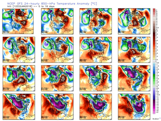
When looking at the GFS 16 day 850hPa temperature anomaly we can see how the cold builds in Northwest Canada and dives Southeast into the Eastern US by the end of the period
2:57 PM - Jan 22, 2018
WeatherBELL
?@weatherbell
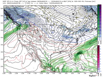
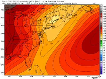
Operational GFS not showing any signs of a winter storm for the Northeast next week, but ensembles are hinting at an inside runner meaning snows possible for interior portions of the region. Temperatures will be cold enough, so a close eye on this one!
11:20 AM - Jan 23, 2018
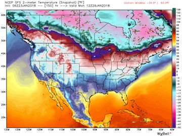
Here is the beginning of the outbreak:

Joe Bastardi weighs in…
View image on Twitter

 Joe Bastardi Joe Bastardi
?@BigJoeBastardi
Wham Bam, Look out GLAAM increasing. another piece of the puzzle of what foretelling could be as frigid a Feb as 2015. Quite Frankly, the worst of winter may be yet to come. that 1933, 1995 ace analog with following winters looking to take over the analog blend for FEb ( 34,96)
5:07 AM - Jan 23, 2018
wattsupwiththat.com |


