Q2 Highlights, Maps&Charts for Point Rousse, Pine Cove&Pine mill, Stog'er tight, Argyle& Goldboro projects
journalpioneer.com
Goldboro construction could start at end of 2021 With the price of gold remaining strong amidst the COVID-19 pandemic, a Canadian mining company is expanding its drilling program at its East Coast sites.
Q2 2020 Highlights
- Anaconda sold 3,712 ounces of gold in Q2 2020, generating metal revenue of $8.4 million at an average realized gold price1 of $2,249 (US$1,674) per ounce sold. As at June 30, 2020, the Company had 470 ounces of gold in gold doré inventory, which was subsequently sold in July.
- Point Rousse produced 3,657 ounces of gold in Q2 2020, a 26% increase compared to Q2 2019, due to higher mill availability. Production for the first six months of 2020 was 8,654 ounces.
- Mine operations produced 111,167 tonnes of ore during the second quarter from the Pine Cove open pit at an average grade of 1.22 g/t at a strip ratio of 5.1 waste tonnes to ore tonnes. The Company ended the second quarter with over 36,000 tonnes of ore in stockpiles.
- The Pine Cove Mill processed 118,333 tonnes during Q2 2020 and achieved a recovery rate of 86.4%, an increase in throughput of 22% compared to Q2 2019 when unplanned maintenance of the regrind mill led to lower mill availability.
- Anaconda announced drill results from multiple locations at the Point Rousse Project, including the Argyle Deposit where work is progressing on a mineral resource, reserve, and development plan, and exciting wide, high-grade intercepts at the Stog'er Tight Deposit.
- The Company initiated a 5,500-metre infill diamond drill program at the Goldboro Gold Project, to convert priority Inferred Mineral Resources, considered proximal to planned development under the ongoing feasibility study, into Indicated Mineral Resources.
- On July 16, 2020, Anaconda announced a non-brokered private placement for up to $5.51 million, which will accelerate its highly prospective exploration and diamond drill programs in Atlantic Canada.
- As at June 30, 2020, the Company had a cash balance of $5.5 million, preliminary working capital1 of $6.1 million, and additional available liquidity of $0.3 million2 from an undrawn revolving line of credit facility.
anacondamining.com
1 Refer to Non-IFRS Measures Section below.
"During the second quarter, amid the ongoing uncertainty related to the COVID-19 pandemic, Anaconda sold 3,712 ounces of gold to generate metal revenue of $8.4 million at record high Canadian dollar gold prices. We have noted some variability to the block model that has impacted tonnes and grade in the second quarter which we are addressing, plus we have also identified areas of opportunities in the Pine Cove open pit based on ongoing blast hole assays and definition drilling which could positively impact the production profile going forward. We are also advancing the development of Argyle and expect to announce further details on the mineral resource and reserve soon, with the potential to accelerate the contribution of ore from Argyle to production. The second quarter also saw the announcement of strong drill results at Stog'er Tight and the initiation of a 5,500 metre drill program at the Goldboro Gold Project. Our $5.5 million of cash combined with our recent private placement of up to $5.51 million gives us the financial wherewithal to execute our growth strategy."
~ Kevin Bullock, President and CEO, Anaconda Mining Inc.
COVID-19 Pandemic Update - Point Rousse has continued to operate throughout the pandemic and to the Company's knowledge, no employees, contractors, or consultants directly involved with Anaconda, whether at corporate or at site, have been diagnosed with COVID-19. Strict health and safety protocols, including social distancing, remain in place and are continually reviewed based on recommendations from medical authorities. Due to the low number of cases in Atlantic Canada, individuals are now able to move between the provinces and the Company has been able to resume its exploration activities, including at the Tilt Cove Gold Project.
Second Quarter Operating Statistics
|
| Three months ended
June 30, 2020
|
|
| Three months ended
June 30, 2019
|
|
| Six months ended
June 30, 2020
|
|
| Six months ended
June 30, 2019
|
| Mine Statistics
|
|
|
|
|
|
|
|
|
|
|
|
| Ore production (tonnes)
|
|
| 111,167
|
|
|
| 78,123
|
|
|
| 214,388
|
|
|
| 155,490
|
| Waste production (tonnes)
|
|
| 561,950
|
|
|
| 427,425
|
|
|
| 1,123,714
|
|
|
| 706,837
|
| Total material moved (tonnes)
|
|
| 673,117
|
|
|
| 505,548
|
|
|
| 1,338,102
|
|
|
| 862,327
|
| Waste: Ore ratio
|
|
| 5.1
|
|
|
| 5.5
|
|
|
| 5.2
|
|
|
| 4.6
|
|
|
|
|
|
|
|
|
|
|
|
|
|
|
|
|
|
| Mill Statistics
|
|
|
|
|
|
|
|
|
|
|
|
|
|
|
|
| Availability (%)
|
|
| 98.4
|
|
|
| 85.8
|
|
|
| 98.1
|
|
|
| 82.0
|
| Dry tonnes processed
|
|
| 118,333
|
|
|
| 96,895
|
|
|
| 231,469
|
|
|
| 176,653
|
| Tonnes per day ("tpd")
|
|
| 1,321
|
|
|
| 1,241
|
|
|
| 1,296
|
|
|
| 1,191
|
| Grade (grams per tonne)
|
|
| 1.11
|
|
|
| 1.25
|
|
|
| 1.34
|
|
|
| 1.55
|
| Recovery (%)
|
|
| 86.4
|
|
|
| 74.7
|
|
|
| 87.0
|
|
|
| 79.3
|
| Gold Ounces Produced
|
|
| 3,657
|
|
|
| 2,907
|
|
|
| 8,654
|
|
|
| 7,083
|
| Gold Ounces Sold
|
|
| 3,712
|
|
|
| 3,153
|
|
|
| 8,843
|
|
|
| 8,404
|
| Operations Overview for the Three Months Ended June 30, 2020
Anaconda sold 3,712 ounces of gold during the second quarter of 2020, generating gold revenue of $8.4 million at an average realized gold price of $2,249 (US$1,674) per ounce sold. Gold production of 3,657 ounces was 26% higher than Q2 2019, due to better mill availability and resulting higher throughput. Low mill availability in Q2 2019 was due to planned maintenance on the main ball mill and unplanned maintenance for the regrind mill. However, gold production in Q2 was down 37% from the first quarter of 2020 due to lower grade, as the mine operation has observed some variability in grade and tonnage in certain lower levels of the Pine Cove pit. Year-to-date production of 8,654 ounces is consistent with the mine plan and the Company remains on track to meet guidance and produce and sell between 18,000 and 19,000 ounces of gold. With mining activity winding down in the Pine Cove open pit, the operation has identified certain opportunities in the pit which may contribute tonnes to the production profile. Also, in light of recent Argyle drill results (see press release dated June 18, 2020) and advancement of the related development plan, the Company is exploring opportunities to accelerate the development of Argyle in the second half of 2020.
1 Refer to Non-IFRS Measures Section below.
Point Rousse Mill Operations - The Pine Cove Mill processed 118,333 tonnes during Q2 2020, an increase of 22% compared to the second quarter of 2019 when a combination of the planned maintenance on the main ball mill with unplanned maintenance on the head of the regrind mill resulted in low mill availability, which impacted throughput. Since the challenges experienced in the second quarter of 2019, the mill has operated consistently and effectively, maintaining high levels of mill availability and throughput since.
Average grade during Q2 2020 was 1.11 g/t, an 11% decrease over the second quarter of 2019, when mill feed was primarily from the higher-grade Stog'er Tight Mine, and a decrease of 31% from Q1 2020 as the mine experienced variability to the block model in certain lower areas of the pit. The mill achieved an average recovery rate of 86.4%, an increase from 74.7% achieved in Q2 2019 despite the lower grade profile in Q2 2020. The higher throughput and better recovery resulted in gold production of 3,657 ounces, an increase of 26% compared to the second quarter of 2019.
Point Rousse Mine Operations - During the second quarter of 2020, the mine operations produced 111,167 tonnes of ore from the Pine Cove Pit, a 42% increase from Q2 2019, which reflects the higher mining rate at the Pine Cove Pit compared to the lower tonnage profile of mining at Stog'er Tight, which was the main mining area in the prior period. The Company ended the second quarter with an ore stockpile of over 36,000 tonnes.
The mine operations achieved a strip ratio of 5.1 waste tonnes to ore tonnes at the Pine Cove Pit, a decrease compared to Q1 2020 as the operation moves into the bottom levels of the Pine Cove Pit. The strip ratio is expected to continue to decrease throughout 2020. The strip ratio is lower compared to the second quarter of 2019 when mining activity included development of the pushbacks to the Pine Cove Pit.
During the second quarter, the mine operation experienced grade and tonnage variability in lower levels of the pit as it approached the outer limits of the mine model. The operation has also identified further tonnage opportunities from blast hole assays, which it will continue to test moving forward. The Company is also expecting permits for Argyle in early August, which could enable accelerated development of the Argyle Deposit.
The Company has critically considered logistical matters given the ongoing COVID-19 pandemic, to ensure that this Drill Program and any other programs are executed in a way that ensures the absolute health and safety of our personnel, contractors, and the communities where we operate.
This news release has been reviewed and approved by Paul McNeill, P. Geo., VP Exploration with Anaconda Mining Inc., a "Qualified Person", under National Instrument 43-101 Standard for Disclosure for Mineral Projects.
A version of this press release will be available in French on Anaconda's website (www.anacondamining.com) in two to three business days.
GOLBORO MINERAL RESOURCE STATEMENT
The technical report from which this Mineral Resource statement is quoted is entitled "Goldboro Gold Project: Resource Update Phase 2, Guysborough County, Nova Scotia" and which is dated December 18, 2019, and with an effective date of August 21, 2019, was authored by independent qualified persons Todd McCracken, P.Geo. of WSP Canada Inc. and Robert Raponi, P. Eng., of Ausenco Engineering Canada Inc. (see news release dated October 31, 2019)
Mineral Resource Statement for the Goldboro Gold Project :
Resource Type
| Au Cut-off
| Category
| Tonnes
| Au
| Troy Ounces
|
| (g/t)
|
| ('000)
| (g/t)
|
| Open Pit
| 0.5
| Measured
| 844
| 2.40
| 65,200
| Indicated
| 111
| 2.63
| 9,400
| Measured + Indicated
| 955
| 2.43
| 74,600
| Inferred
| 22
| 2.79
| 2,000
| Underground
| 2.0
| Measured
| 967
| 6.08
| 189,200
| Indicated
| 2,174
| 6.22
| 434,800
| Measured + Indicated
| 3,141
| 6.18
| 624,000
| Inferred
| 2,985
| 7.12
| 683,200
| Combined*
| 0.5/2.0
| Measured
| 1,811
| 4.37
| 254,400
| Indicated
| 2,285
| 6.05
| 444,200
| Measured + Indicated
| 4,096
| 5.30
| 698,600
| Inferred
| 3,007
| 7.09
| 685,100
|
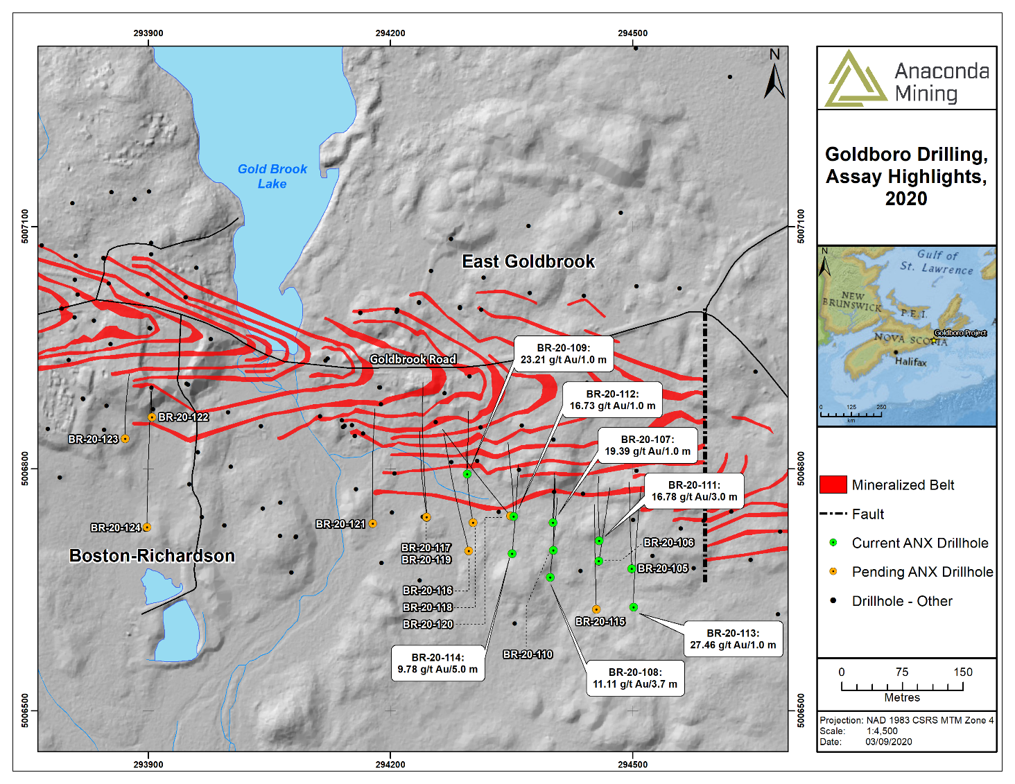
Exhibit A: A map showing the location of drill holes and selected composited highlights.
^Mineral Resource Estimate Notes
| Argyle is a near-term development project and Anaconda anticipates making a final production decision with respect to Argyle in the third quarter of 2020.
Table 1: Highlighted composited assays from diamond drill holes AE-20-134 to 157
Hole ID1
| From (m)
| To (m)
| Interval (m)2
| Au (g/t)
| AE-20-134
| 35.7
| 36.2
| 0.5
| 10.40
| AE-20-135
| 22.6
| 29.6
| 7.0
| 1.19
| AE-20-136
| 34.2
| 35.2
| 1.0
| 0.86
| AE-20-137
| 31.0
| 31.6
| 0.6
| 4.56
| AE-20-138
| 37.0
| 41.5
| 4.5
| 4.56
| including
| 39.5
| 40.0
| 0.5
| 24.70
| AE-20-140
| 19.5
| 23.5
| 4.0
| 5.26
| and
| 26.5
| 27.1
| 0.6
| 1.59
| AE-20-141
| 8.7
| 11.7
| 3.0
| 1.18
| and
| 15.7
| 16.7
| 1.0
| 1.41
| AE-20-142
| 11.0
| 12.0
| 1.0
| 0.79
| and
| 14.0
| 17.0
| 3.0
| 1.32
| and
| 25.2
| 26.2
| 1.0
| 3.14
| AE-20-143
| 15.0
| 23.5
| 8.5
| 2.16
| AE-20-144
| 10.8
| 11.8
| 1.0
| 1.19
| AE-20-146
| 49.0
| 50.0
| 1.0
| 1.55
| and
| 60.4
| 61.4
| 1.0
| 1.36
| and
| 73.7
| 74.3
| 0.6
| 1.00
| AE-20-147
| 57.5
| 58.5
| 1.0
| 1.54
| and
| 67.5
| 68.4
| 1.1
| 8.71
| AE-20-148
| 14.7
| 15.2
| 0.5
| 0.63
| and
| 18.5
| 19.5
| 1.0
| 1.90
| AE-20-150
| 66.0
| 67.0
| 1.0
| 2.79
| AE-20-151
| 64.0
| 66.0
| 2.0
| 4.02
| and
| 73.5
| 75.0
| 1.5
| 0.79
| AE-20-156
| 35.0
| 36.0
| 1.0
| 2.20
| AE-20-157
| 42.0
| 44.0
| 2.0
| 3.98
| Footnotes:
1 - Diamond drill holes AE-20-139, 145, 149, 152-155 have no significant assays.
2 - Interval expressed as core length only; true thickness estimated to be 90-100% of interval length.
Table 2: Highlighted composited assays from percussion drill holes AEP-20-26 to 86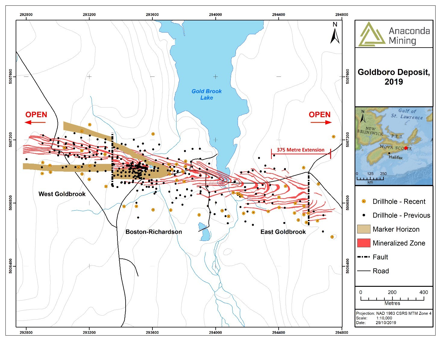
Hole ID3
| From (m)
| To (m)
| Interval (m)4
| Au (g/t)
| AEP-20-26
| 15.54
| 16.45
| 0.91
| 2.88
| AEP-20-31
| 8.23
| 9.14
| 0.91
| 0.69
| AEP-20-36
| 4.57
| 6.40
| 1.83
| 0.99
| AEP-20-37
| 4.57
| 6.40
| 1.83
| 1.89
| AEP-20-38
| 7.32
| 10.98
| 3.66
| 1.36
| AEP-20-42
| 9.14
| 10.97
| 1.83
| 0.99
| AEP-20-43
| 8.23
| 9.14
| 0.91
| 1.02
| AEP-20-45
| 8.23
| 10.06
| 1.83
| 1.99
| AEP-20-46
| 7.32
| 10.98
| 3.66
| 1.43
| AEP-20-47
| 9.14
| 10.05
| 0.91
| 2.52
| AEP-20-48
| 1.83
| 9.15
| 7.32
| 1.87
| including
| 7.32
| 8.23
| 0.91
| 6.34
| AEP-20-49
| 11.89
| 16.46
| 4.57
| 2.15
| AEP-20-50
| 10.97
| 15.54
| 4.57
| 6.62
| AEP-20-51
| 8.23
| 9.14
| 0.91
| 2.64
| AEP-20-52
| 6.40
| 10.97
| 4.57
| 3.14
| AEP-20-53
| 8.23
| 12.80
| 4.57
| 2.07
| AEP-20-54
| 3.66
| 8.23
| 4.57
| 1.34
| AEP-20-56
| 9.14
| 10.97
| 1.83
| 4.73
| AEP-20-57
| 0.91
| 1.82
| 0.91
| 1.54
| and
| 3.66
| 4.57
| 0.91
| 3.23
| AEP-20-58
| 1.83
| 5.49
| 3.66
| 1.68
| AEP-20-60
| 20.12
| 21.03
| 0.91
| 2.27
| AEP-20-61
| 0.91
| 1.82
| 0.91
| 0.91
| and
| 3.66
| 6.40
| 2.74
| 1.94
| AEP-20-67
| 0.91
| 2.74
| 1.83
| 2.40
| AEP-20-69
| 10.06
| 10.97
| 0.91
| 0.97
| AEP-20-70
| 17.37
| 18.28
| 0.91
| 1.83
| AEP-20-71
| 1.83
| 2.74
| 0.91
| 1.92
| AEP-20-76
| 0.91
| 2.74
| 1.83
| 0.74
| AEP-20-78
| 7.32
| 16.46
| 9.14
| 4.48
| including
| 9.14
| 10.05
| 0.91
| 16.60
| AEP-20-79
| 6.40
| 9.14
| 2.74
| 2.42
| AEP-20-80
| 8.23
| 10.06
| 1.83
| 1.01
| AEP-20-81
| 10.97
| 11.88
| 0.91
| 0.86
| Footnotes:
3 - Percussion drill holes AEP-20-27-30, 32-35, 39-41, 44, 55, 59, 62-66, 68, 72-75, and 77 have no significant assays.
4 - Interval expressed as core length only; true thickness estimated to be 90-100% of interval length.
About Argyle
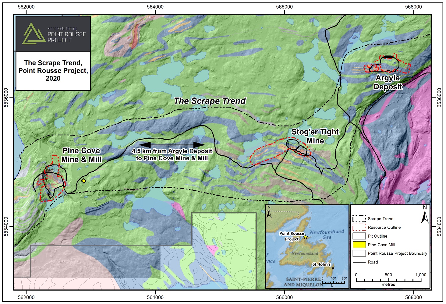
The Argyle Deposit, located 4.5 kilometres east of the Pine Cove Mill adjacent to existing road networks, is defined over a strike length of 685 metres and to a down-dip extent of 225 metres and is open for expansion. The Argyle Deposit was subject to a detailed NI 43-101 Technical Report titled "NI 43-101 Technical Report, Mineral Resource and Mineral Reserve Update Point Rousse Project, Baie Verte, Newfoundland and Labrador, Canada" with an effective date of December 31, 2017. Since the December 2017 Resource, a total of 7,940 metres in 152 drill holes have been completed at Argyle.
Argyle Mineral Resource Estimate - Effective Date: December 31, 2017
Resource Category
| Resource Cut-off Gold Grade
(g/t)
| Tonnes
(Rounded)
| Gold Grade (g/t)
(12 g/t Capping Factor)
| Gold Ounces
(Rounded)
| Indicated
| 0.5
| 543,000
| 2.19
| 38,300
| Inferred
| 0.5
| 517,000
| 1.82
| 30,300
| anacondamining.com
The results of the Drill Program indicate that a significant zone of gold mineralization extends at least 650 metres west of, and represents a strike extension of, the Stog'er Tight Mine sequence. Mineralization at Stog'er Tight now extends over a total strike length of 1,200 metres and is open along strike to the southwest and down-dip on its western half. Gold mineralization is hosted within a shallowly northwest dipping gabbro sill and is tested to a vertical depth of 75 metres. The highest grades and thicknesses intersected thus far are associated with a geophysical anomaly (IP chargeability high associated with all gold deposits at Point Rousse) that extends 250 metres northward, parallel with a similar IP anomaly associated with the Stog'er Tight Deposit. A second IP chargeability anomaly, of similar extent and associated with surface gold mineralization, is located 250 metres further southwest along strike, highlighting additional potential for expansion (Exhibit C). Both geophysical anomalies trend beneath a shallow pond (generally less than a few metres) known as Camp Pond (Exhibit B and C). Fox Pond, located east of Camp Pond, was similarly underlain by the Stog'er Tight Deposit which was successfully mined in 2018 and 2019 by partial dewatering of the pond under appropriate Provincial and Federal Government permits.
Table 1: Highlighted composited assays from diamond drill holes BN-19-293 to BN-20-318
Drill hole1
| From (m)
| To (m)
| Interval (m)2
| Gold (g/t)
| BN-19-294
| 24.0
| 37.0
| 13.0
| 1.15
| including
| 32.0
| 37.0
| 5.0
| 2.26
| and
| 36.0
| 37.0
| 1.0
| 5.76
| BN-19-295
| 25.0
| 33.0
| 8.0
| 5.55
| including
| 30.0
| 33.0
| 3.0
| 14.45
| including
| 30.0
| 31.0
| 1.0
| 39.70
| BN-19-296
| 35.0
| 36.0
| 1.0
| 0.61
| BN-19-299
| 12.0
| 14.0
| 2.0
| 0.97
| BN-19-300
| 8.0
| 10.0
| 2.0
| 1.16
| BN-19-300
| 20.7
| 21.7
| 1.0
| 28.10
| BN-19-301
| 20.0
| 23.0
| 3.0
| 1.06
| BN-20-304
| 10.0
| 11.0
| 1.0
| 15.10
| BN-20-306
| 9.0
| 10.0
| 1.0
| 0.50
| BN-20-308
| 17.0
| 18.0
| 1.0
| 0.85
| BN-20-309
| 42.0
| 43.0
| 1.0
| 2.73
| BN-20-309
| 48.0
| 53.0
| 5.0
| 18.42
| including
| 50.0
| 51.0
| 1.0
| 74.40
| BN-20-309
| 63.0
| 64.0
| 1.0
| 0.80
| BN-20-310
| 23.0
| 24.0
| 1.0
| 0.58
| BN-20-310
| 28.0
| 35.0
| 7.0
| 10.14
| including
| 32.0
| 33.0
| 1.0
| 33.90
| BN-20-311
| 35.0
| 36.0
| 1.0
| 1.91
| BN-20-311
| 44.0
| 64.0
| 20.0
| 5.45
| including
| 55.0
| 56.0
| 1.0
| 33.90
| including
| 62.0
| 63.0
| 1.0
| 17.10
| BN-20-312
| 11.0
| 13.0
| 2.0
| 1.63
| BN-20-315
| 27.0
| 30.0
| 3.0
| 5.05
| BN-20-316
| 61.0
| 62.0
| 1.0
| 1.69
| BN-20-318
| 39.0
| 40.0
| 1.0
| 0.71
| Footnotes:
1 - Diamond drill holes BN-19-293, 297, 298, 302 and BN-20-302, 303, 305, 307, 313, 317 have no significant assays.
2 - Interval expressed as core length only; true thickness estimated to be 75-100% of interval length.
Table 2: Highlighted composited assays from percussion drill holes BNP-19-164 to BNP-20-190
Drill hole3
| From (m)
| To (m)
| Interval (m)4
| Gold (g/t)
| BNP-20-170
| 15.5
| 17.4
| 1.9
| 1.57
| BNP-20-174
| 3.7
| 6.4
| 2.7
| 1.70
| BNP-20-176
| 0.9
| 1.8
| 0.9
| 0.86
| BNP-20-180
| 1.8
| 3.7
| 1.9
| 1.73
| BNP-20-182
| 11.0
| 14.6
| 3.6
| 1.67
| BNP-20-185
| 1.8
| 2.7
| 0.9
| 0.54
| and
| 4.6
| 5.5
| 0.9
| 1.15
| Footnotes:
3 - Percussion drill holes BNP-19-164-169, BNP-20-171-173, 175, 177-179, 181, 183, 184, and 186-190 have no significant assays.
4 - Interval expressed as core length only; true thickness estimated to be 90-100% of interval length.
About Stog'er Tight
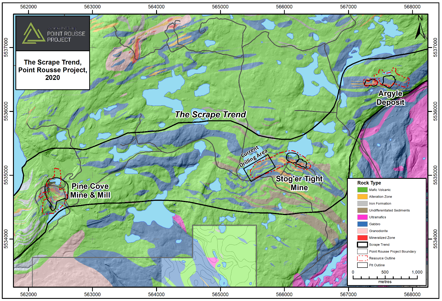
Exhibit A. A map showing the location of the Stog'er Tight Deposit in the central part of the Scrape Trend; A geological trend that is host to the Stog'er Tight Mine, Argyle Deposit and Pine Cove Mine and Mill Complex, Point Rousse Project.
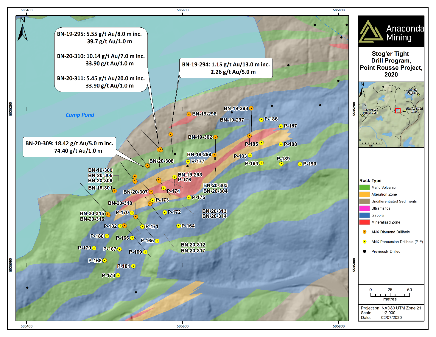
Exhibit B. A map showing the location of diamond and percussion drill holes completed during the Drill Program referenced in the press release with highlight assays.
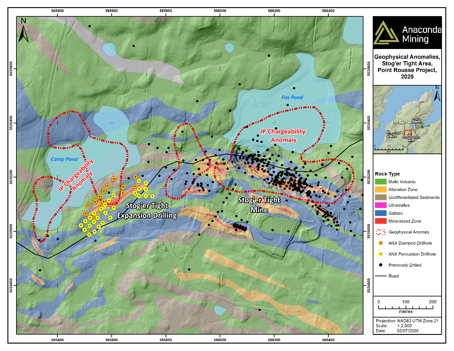
Exhibit C. A map showing the location of the Stog'er Tight Deposit, the area of the recent Drill Program and the IP geophysical anomalies and exploration targets. The location of Camp Pond and Fox Pond and associated IP anomalies are also shown.
SOURCE: Anaconda Mining Inc.
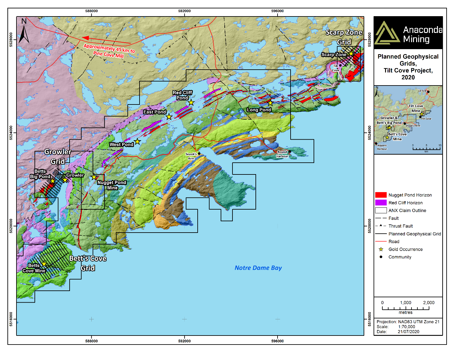
Exhibit A. A map showing the location of the Tilt Cove Project, as well as high priority exploration targets referenced in the press release, including the Growler Showing East, West and Scarp Zone Targets.
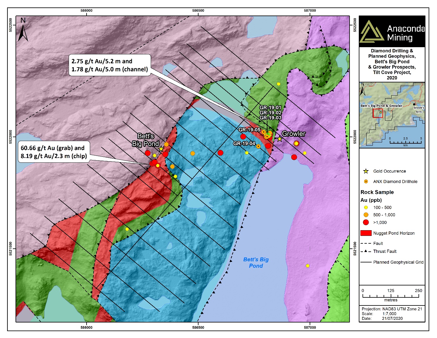
Exhibit B. A map outlining the extent of the Growler area, showing two kilometers of prospective strike associated with the NPH and including the recently discovered Growler and Betts Big Pond showings. Drill holes and results of recent channel samples and historic chip samples are show for the Growler and Betts Big Pond Showings.
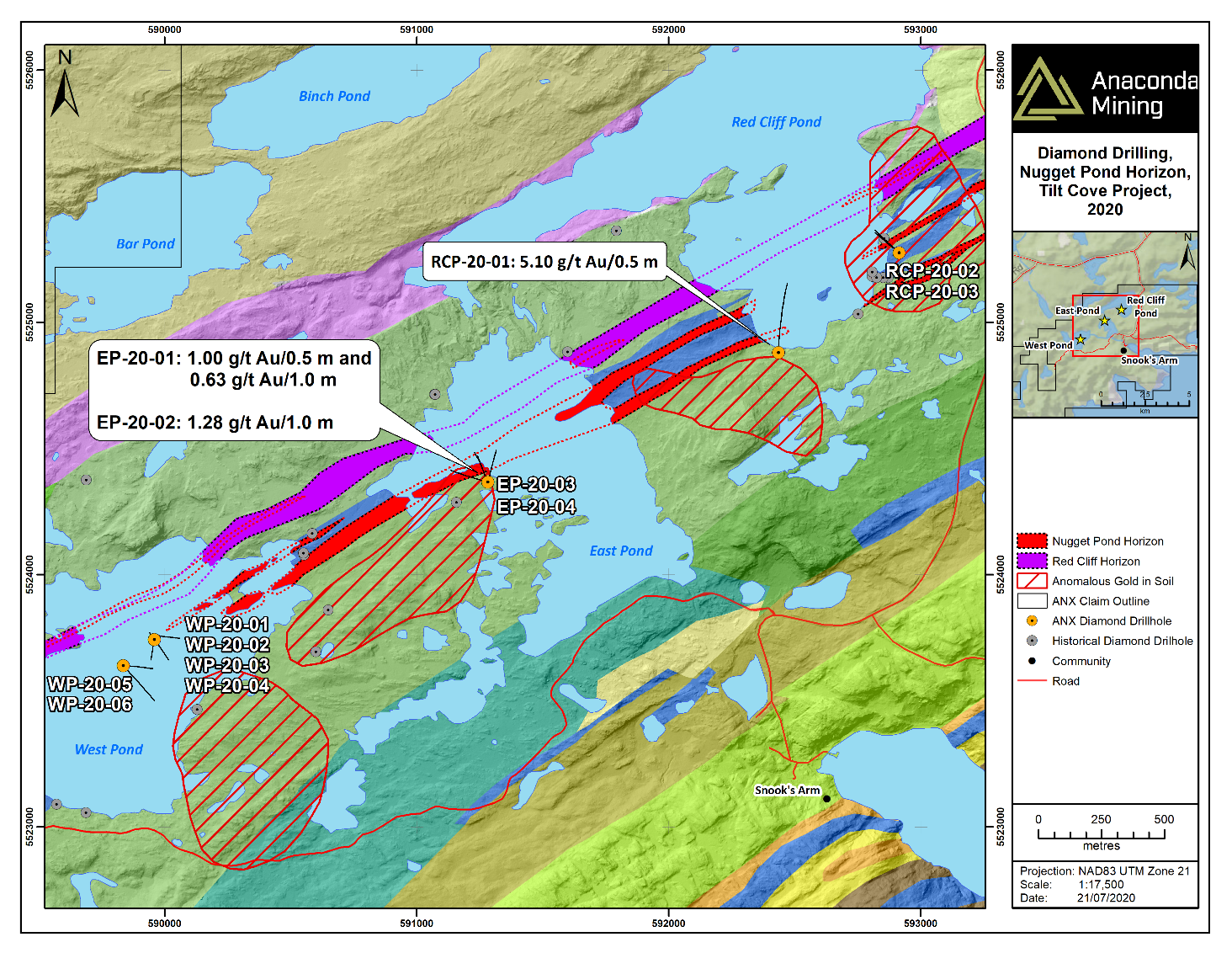
Exhibit C. A map showing the location of high priority exploration targets including drill holes from the Winter Program at the West Pond, East Pond and Red Cliff Pond. Gold-in-soil anomalies are shown in red polygons and are located down-ice (southeast) of the Nugget Pond and Red Cliff Horizons. The Nugget Pond Deposit was situated immediately up-ice of a similar gold-in-soil anomaly.
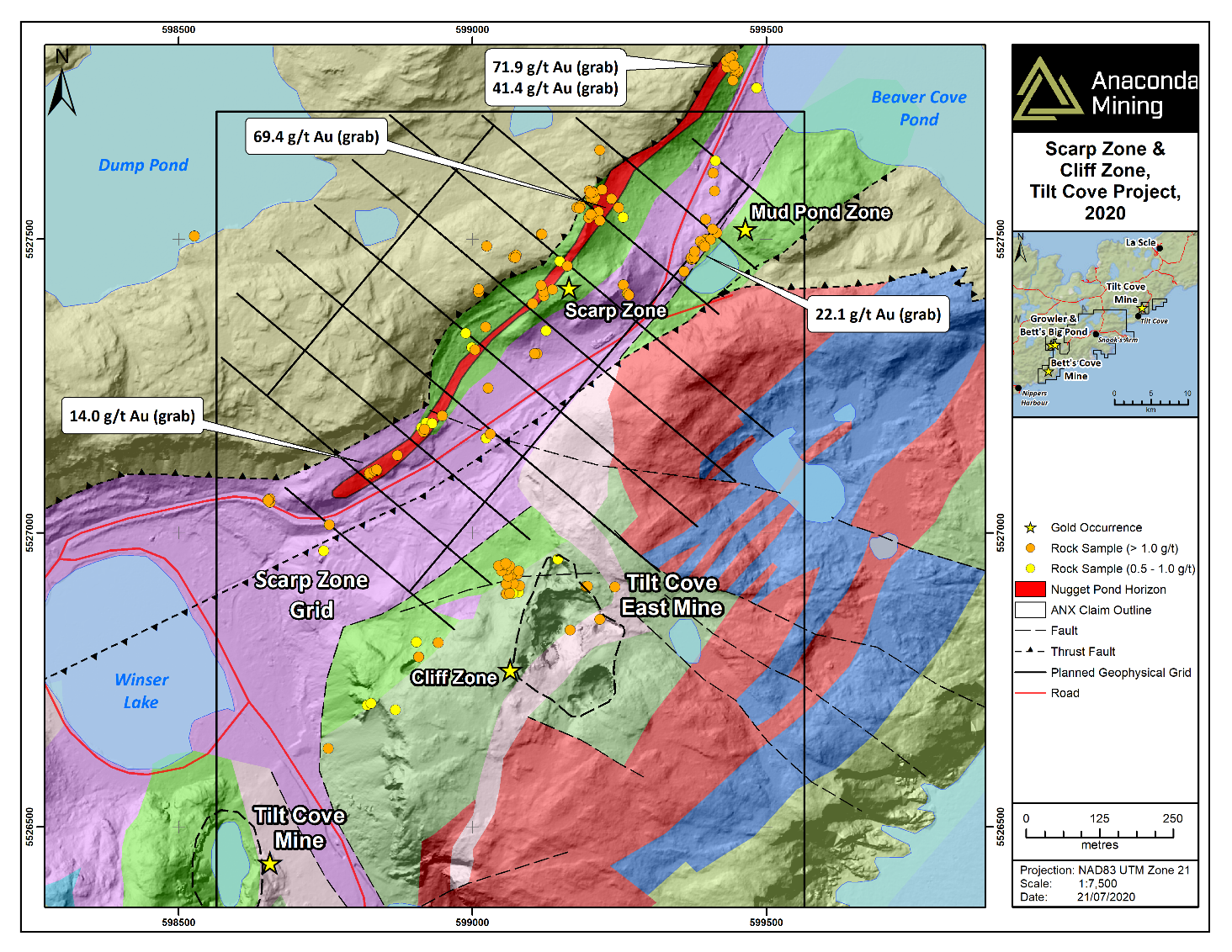
Exhibit D. A map showing the Scarp Zone characterized by more than a kilometre of anomalous gold samples greater than 0.5 g/t gold, a strong deformation zone and associated with a past producing, gold rich base metal mine (the Tilt Cove Mine).
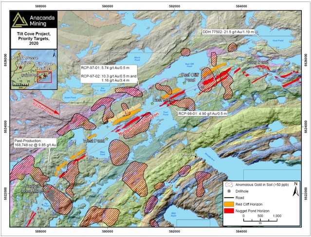
Exhibit A. A map showing the location of high priority exploration targets including the West Pond, East Pond, Red Cliff Pond and Long Pond. Gold-in-soil anomalies are shown in black polygons and are located down-ice (southeast) of the Nugget Pond and Red Cliff Horizons where drill target areas at West Pond and Redcliff Pond are located. The Nugget Pond Deposit was situated immediately up-ice of a similar gold-in-soil anomaly.
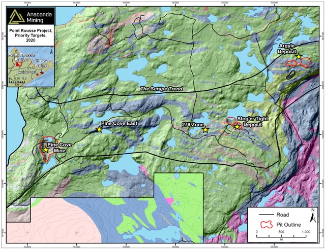
Exhibit B. A map showing the location of high priority exploration targets including the Argyle, 278 Zone (Stog'er Tight Mine), Pine Cove and Pine Cove East targets.
|


