| | | WA’s mountain snow recharges our drinking water, powers our lives. Now it’s turning to rain.
Feb. 4, 2024 at 6:00 am Updated Feb. 4, 2024 at 6:00 am
By
Conrad Swanson
Seattle Times climate reporter
Climate Lab is a Seattle Times initiative that explores the effects of climate change in the Pacific Northwest and beyond. The project is funded in part by The Bullitt Foundation, Mike and Becky Hughes, University of Washington and Walker Family Foundation, and its fiscal sponsor is the Seattle Foundation. Learn more about Climate Lab from our executive editor.
DIABLO LAKE, North Cascades National Park — The clouds lifted by noon and wind screamed down the mountainsides.
Temperatures sunk to zero as Jon Riedel, a retired geologist with the National Park Service, stood on a ridge above the blue-green reservoir, which holds water that will later be released to spin the turbines at the dam here and help power Seattle.
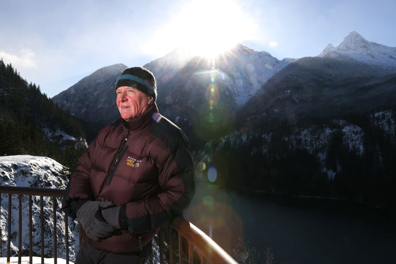
Jon Riedel, an expert in hydrology and glaciers who is retired from the National Park Service, enjoys a cold, clear day at the Diablo Lake Overlook in North Cascades National Park. (Karen Ducey / The Seattle Times)
Riedel scanned the peaks across the horizon and explained the ongoing decline of Washington’s glaciers and snowpack.
Both are suffering as the region warms. Cities, tribes, farms and fish in Western Washington rely on water from a consistent balance of rain and snow to create electricity, provide drinking water, irrigate land and quench the natural environment.
But that balance is shifting.
Related CLIMATE LAB Precipitation that once fell as snow is instead falling as rain, and the snow that does reach the ground is melting earlier in the year as our dry season trends longer and hotter. All told, Washington will see more water when it doesn’t need it and less water when it does.
This creates a challenge unique to the Pacific Northwest. Our system of waterways and reservoirs isn’t designed to capture as much of that rainwater as we need.
Since 1955 the region’s snowpack has shrunk by a third, according to a 2020 report from the University of Washington’s Climate Impacts Group. Depending on how fast global emissions continue to heat the atmosphere, snowpack could dwindle up to 70% more by the 2080s.
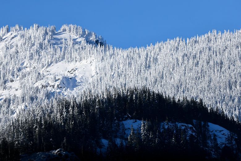
The snow line stands out on the mountains and forests Jan. 12 along Highway 20 in North Cascades National Park. (Karen Ducey / The Seattle Times)
Riedel moved to nearby Marblemount in the late 1980s to study glaciers, and his team spent the past few decades tracking their deterioration. In a century they’ve halved in size, he said.
The changes are even more pronounced when Riedel checks the data indicating a sharp decrease in the amount of precipitation falling as snow on the North Cascades.
“It’s like getting hit in the head with a 2-by-4,” he said.
Washington saw glimpses of its future last summer and fall, when a drought gripped the state and officials implored or required people to use less water. The same thing happened in 2015. These water restrictions, and other onerous effects, like rising utility rates, dying salmon, poor harvests and wildfires, are expected to become more common problems.
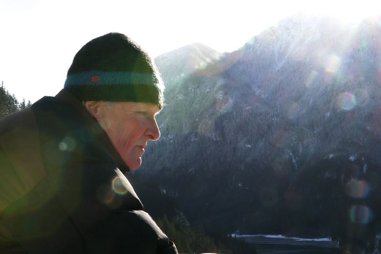
Jon Riedel and his team spent decades tracking the deterioration of glaciers in the North Cascades. In a century they’ve halved in size, he said. (Karen Ducey / The Seattle Times)
As spring turns to summer, snowpack acts as a giant and frozen reservoir, melting gradually and flowing into the state’s relatively small, dammed reservoirs, when there is room to spare, said Guillaume Mauger, a research scientist with UW’s Climate Impacts Group.
The process involves a staggering amount of water.
Washington’s annual peak mountain snowpack can hold as much as 25 million acre-feet, according to Mauger and his colleague, Matt Rogers. That would be enough to supply Seattle’s drinking water for 181 years.
Shrinking snowpack could also melt four to six weeks earlier than normal. The rain that falls instead of snow fills the reservoirs fairly quickly and any excess precipitation must flow through the dams and into the sea.
The shift in the state’s water supply will in the decades to come require water managers to tap other sources or build out storage, at great expense to ratepayers.
We’ll have to do more with less water.
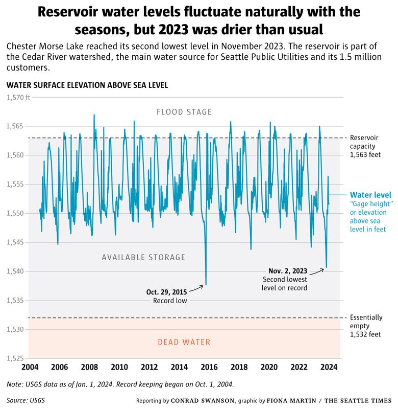
Chester Morse Lake, surrounded by green on the first day of winter, is part of the Cedar River watershed, the main water source for Seattle Public Utilities and its 1.5 million customers. (Karen Ducey / The Seattle Times)
Seattle Public Utilities’ water supply concerns
Chester Morse Lake, within the Cedar River watershed, is Seattle Public Utilities’ largest reservoir of drinking water.
It is a tightly controlled area about 26 miles southeast of Seattle off-limits to hikers or any other visitors, except for members of the Muckleshoot Indian Tribe and utility officials. SPU spent decades buying surrounding land to safeguard it.
An old wooden sign, speckled with green moss and blue-gray lichen, stands near the reservoir’s edge. It reads:
“THIS AREA PROVIDES DRINKING WATER FOR OVER ONE MILLION PEOPLE PLEASE PROTECT IT.”
Most Read Local Stories Now it serves closer to 1.5 million people, and may be more threatened than ever.
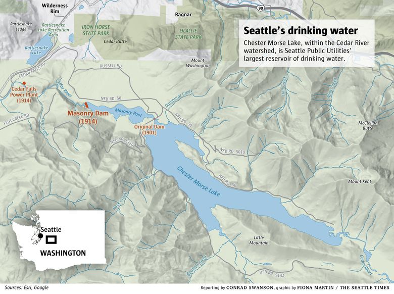
Chester Morse holds a small fraction of the water held by its massive cousins in the American Southwest, like at lakes Mead and Powell. So Chester Morse fluctuates between empty and full much more easily.
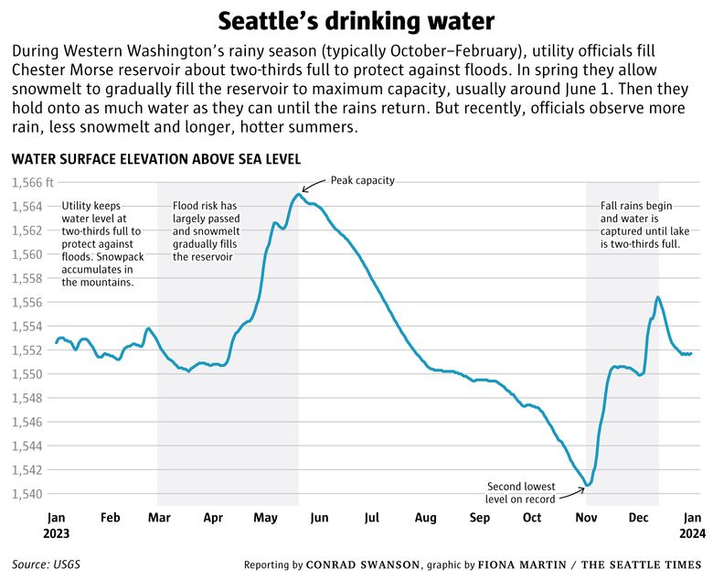
Less snow and faster melt-offs mean the water at Chester Morse and reservoirs like it peaks earlier in the year, sometimes a month early, said Julie Crittenden, SPU’s water planning and program manager.
Combined with later fall rains and drier summers, it means the utility must lean on these reserves to last much longer each year.
It’s a complicated task for a system not designed to handle the new reality.
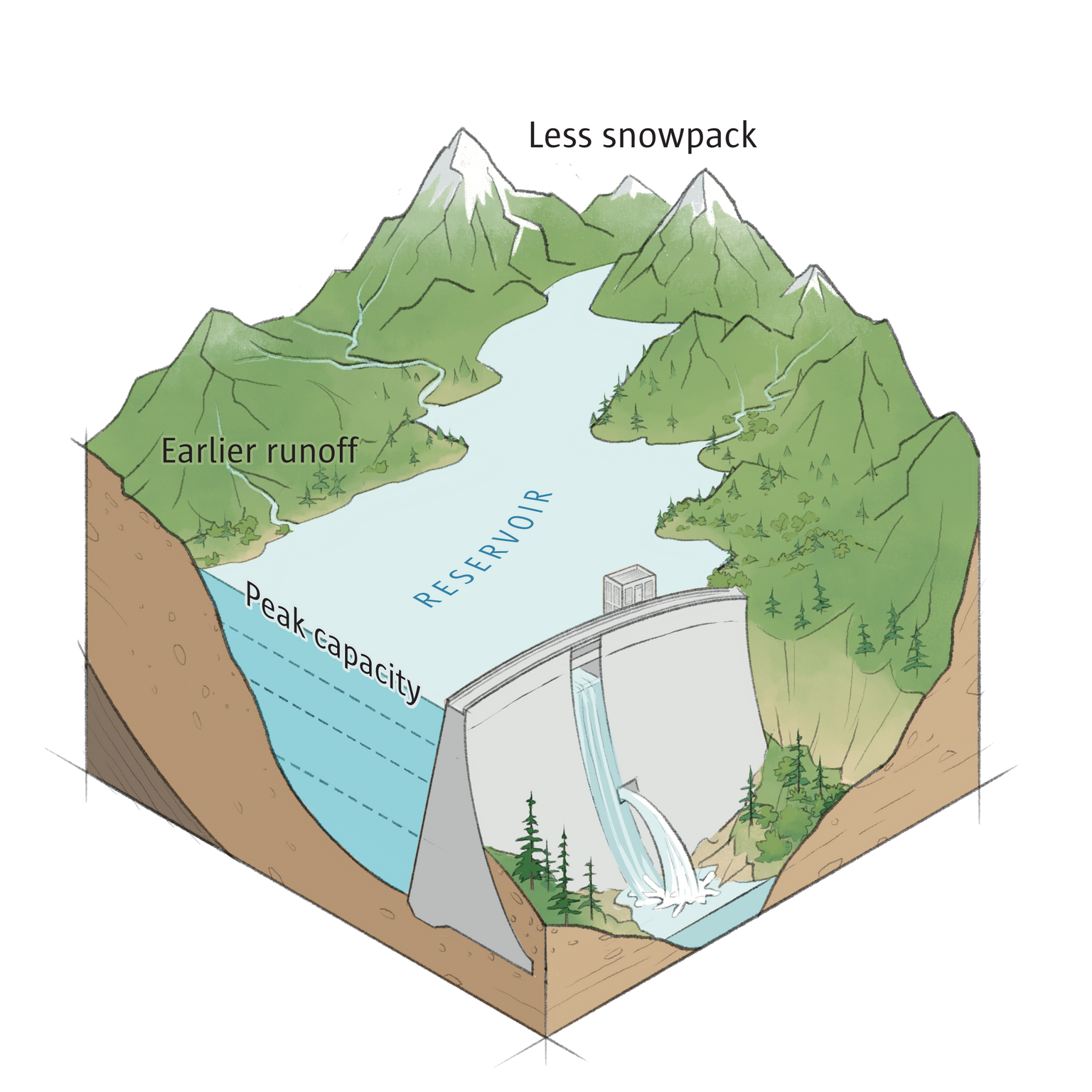
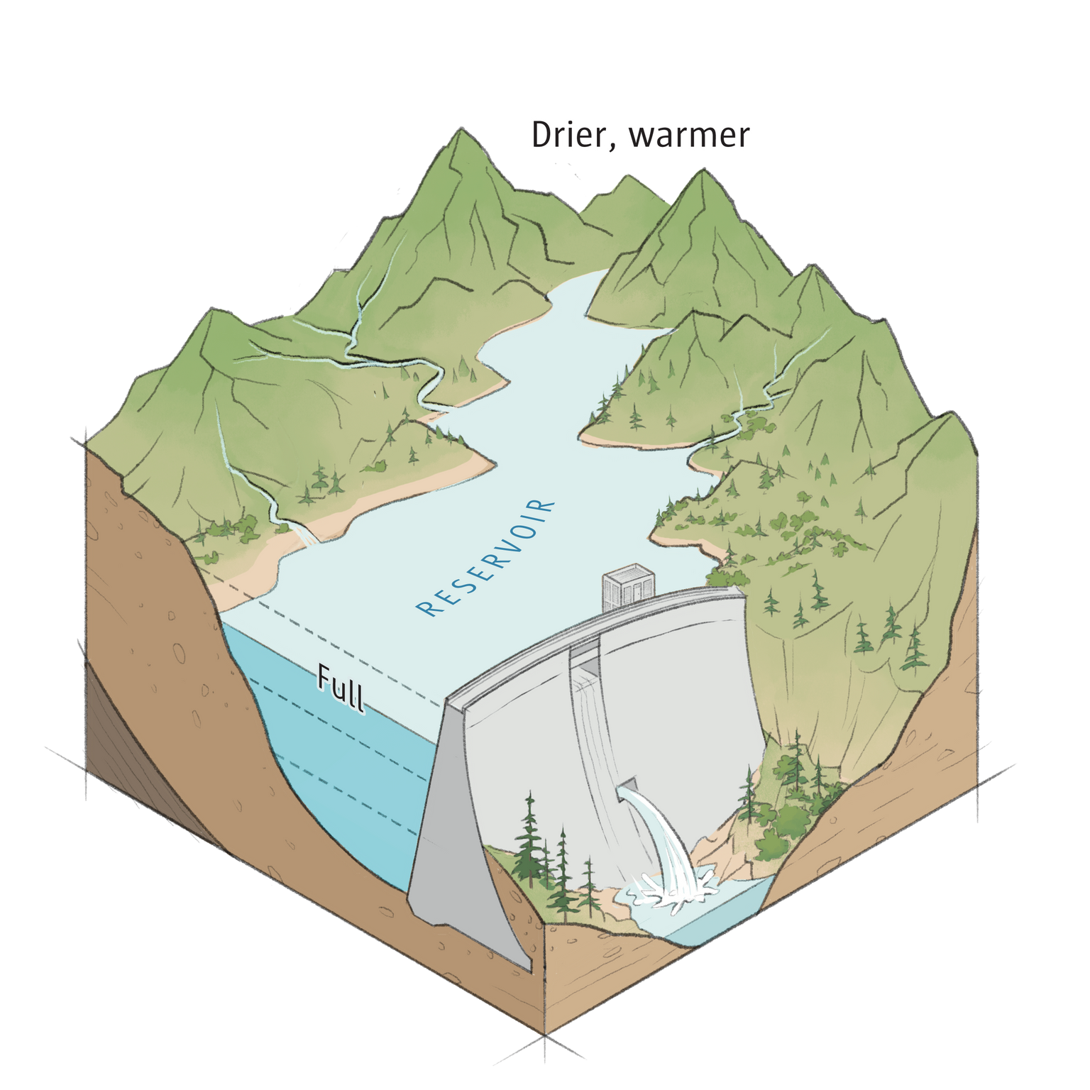
How warming is affecting a mountain reservoir The “water year” begins Oct. 1. As temperatures in the Pacific Northwest rise with climate change, the reservoir system that provides our drinking water and generates electricity is being stressed.
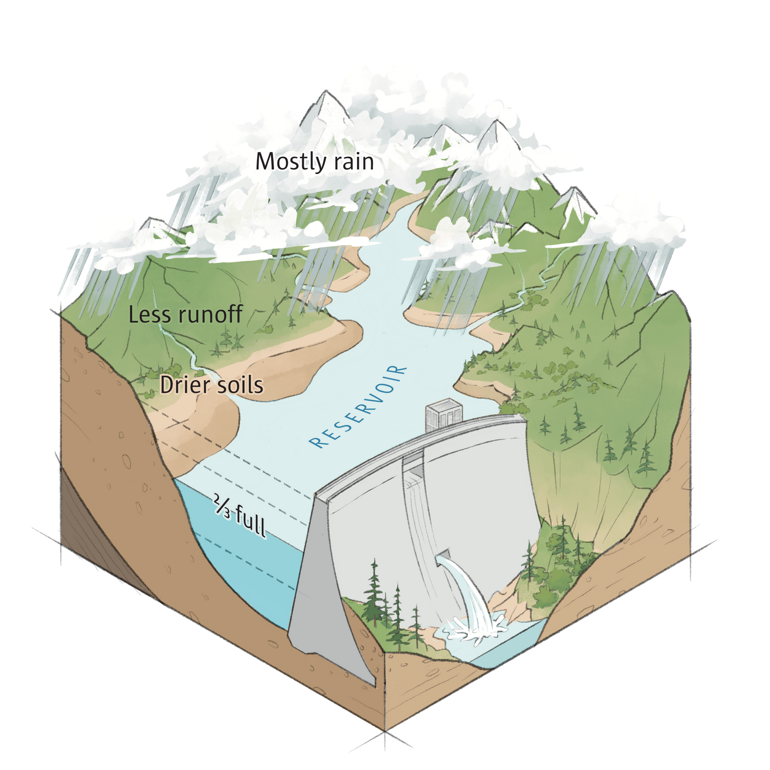   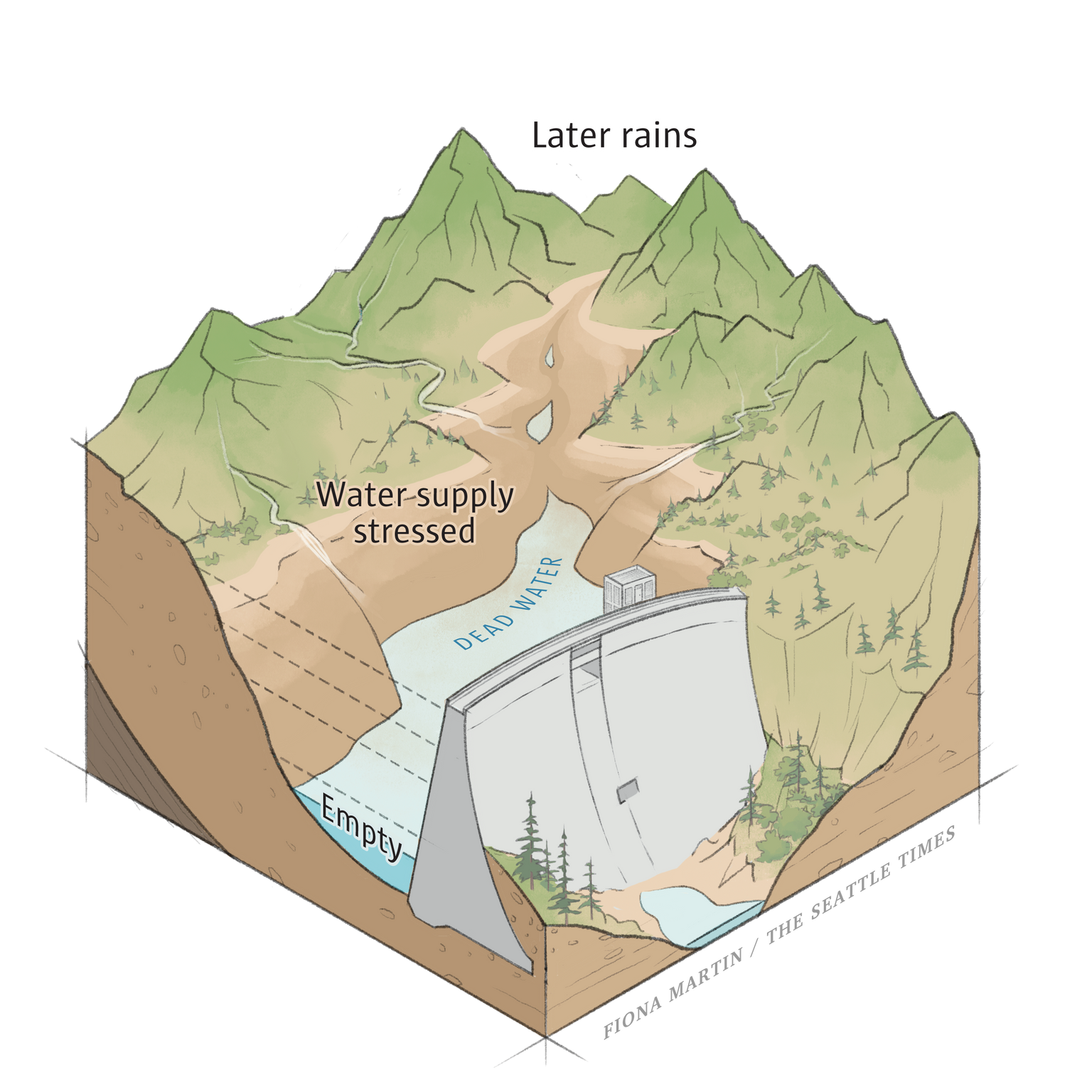
Winter: Autumn and winter rains that replenish the reservoir are arriving later and fall on drier-than-normal soils. The ground acts like a sponge first before releasing water into the reservoir.
Spring: Snowpack gradually releases snowmelt into the reservoir as temperatures rise. But winter rains aren’t freezing as often and quickly fill the reservoir, so the utility must let excess water wash downstream to the sea.
Summer: Snowpack has melted off a month earlier than usual. The city must rely on water it has in reserve over a longer period until the rains return.
Fall: Summer was hotter, drier and longer than normal. The reservoir drops to its lowest level, which hampers hydropower generation and limits drinking water supply.
Elizabeth Garcia and several of her new team members slowly walked the concrete path atop Masonry Dam, which they control to speed or slow the release of water out of Chester Morse. They peered over the side and watched the steady stream roaring out of the 48-inch spill valve.
The team can allow the reservoir to fill a few feet higher than normal to store more water for the dry season, Garcia said. Too high, though, and the utility runs greater flood risk if a major downpour hits.
Water spills out of the Masonry Dam into the Cedar River. The Cedar River watershed is the main water source for Seattle Public Utilities and its 1.5 million customers. (Karen Ducey / The Seattle Times)
Or they can draw the reservoir a little lower, Garcia said. Too low and they’ll hit “dead storage,” the point where silt and debris can enter the stream. This would lead to water quality concerns and the Cedar River doesn’t have any filtration infrastructure in place.
The utility could also lean more heavily on its other water source, the South Fork Tolt River, Garcia said. That’s a smaller river, though, and can only provide so much water.
Eventually SPU will have to develop a new source of water, said Alex Chen, director of SPU’s drinking water division. If current projections hold, that time won’t come for another 30 or 40 years but the utility must plan well into the future because the undertaking could take decades to finish.
Expanding reservoirs, installing filtration systems or developing a new source of water would all come at substantial cost. And Seattle’s water rates already sit among the country’s highest.
Ray Hoffman, CEO of the Cascade Water Alliance, said it could take up to 40 years to develop a new source of water, depending on whether a water provider has rights to the resource.
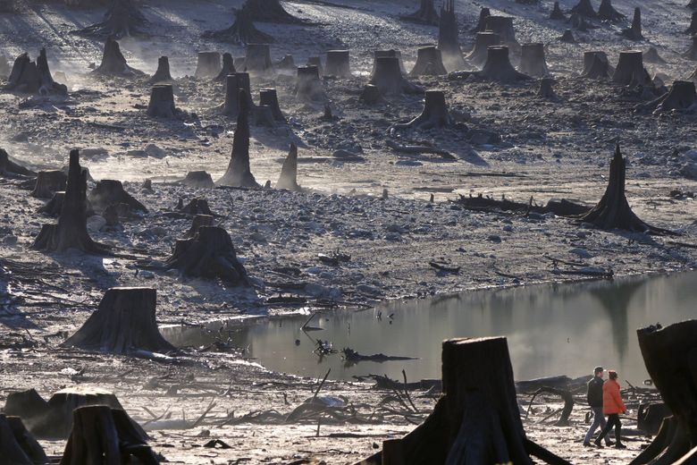
Visitors walk among tree stumps on the lake bed of Rattlesnake Lake near North Bend on a morning in late December. The lake, which sank to its second-lowest level on record is fed by the nearby Chester... (Karen Ducey / The Seattle Times)
The Alliance, which buys water from SPU and serves some 400,000 customers in areas like Bellevue, Kirkland, Redmond, Issaquah and Tukwila, has the rights to dip into Lake Tapps but would still need to build a system to deliver the water to customers, and picking the right moment to start is difficult, Hoffman said.
Climate models can only offer so much insight into the future, Hoffman said.
“What if it happens 15 years faster?” Hoffman said. “You better have a Plan B and you better have a Plan C.”
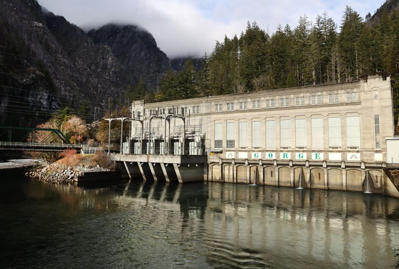
The Gorge Powerhouse sits along the Skagit River in Newhalem in the North Cascades. (Karen Ducey / The Seattle Times)
Seattle City Light’s hydropower problems
Eight miles east of the Diablo Lake overlook, the snow- and glacier-fed waters transform into the unobstructed Skagit River, having passed through three sets of hydropower turbines belonging to Seattle City Light.
Electricity from the utility’s Ross, Diablo and Gorge dams ultimately flows to Seattle. Those dams make up one of City Light’s two major hydropower projects. The other, the Boundary Dam, sits on the Pend Oreille River in Northeast Washington. Together, they provide about half the utility’s electricity.
Whatever demand City Light can’t meet on its own, it buys off the grid, generally from the federal Bonneville Power Administration.
Historically City Light has been a “winter peaker,” said the utility’s chief financial officer, Kirsty Grainger. That means the highest demand comes in winter, when there’s plenty of water available to generate power. But increasingly the utility is transforming into a “dual peaker,” as hotter summers and air conditioning drive energy demand upward, she said.
Those summer months present a problem.
Like with drinking water, City Light’s hydropower reserves are peaking earlier in the year. And the strain is widening a summer gap in resources when there’s not enough water to generate the needed electricity.
So interim CEO Mike Haynes said the utility must supplement with more power from elsewhere, which is expensive.
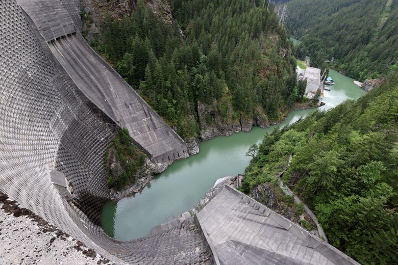
Ross Dam looms more than 500 feet over its powerhouse downstream on the Skagit River, part of the Seattle City Light Hydroelectric Project that supplies power to the city of Seattle. (Karen Ducey / The Seattle Times)
The need was so strong last year that City Light burned through more than $70 million in emergency reserves and in October announced a 4% rate hike to build back the account. Those rates will remain higher until the fund is replenished, which will depend on the amount of water the utility can capture in the coming months.
Despite a spate of blizzards and heavy rainstorms, the state’s snowpack remains below average and El Niño conditions don’t promise much improvement in the near future.
City Light must adapt by diversifying, Haynes said. The utility will lean heavily into wind and solar power to make up for the summer gap.
About 5% of City Light’s energy currently comes from wind farms, but by 2040 that should quadruple, Haynes said. Solar projects are also expected to increase, though not quite as much.
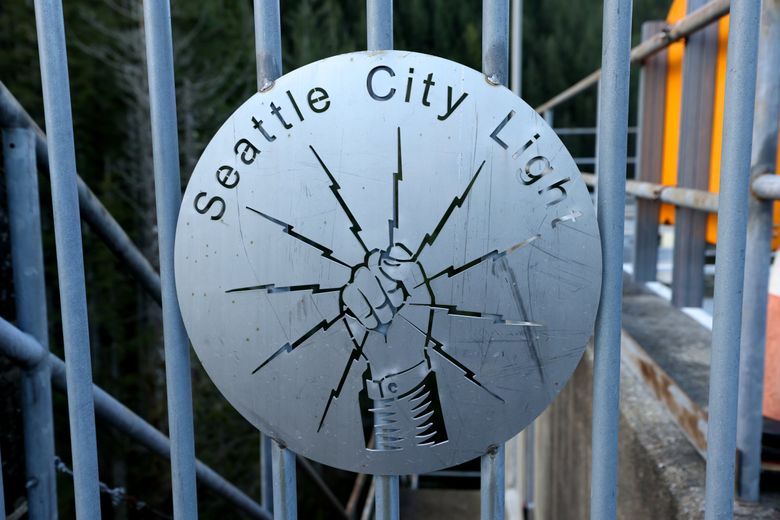
A Seattle City Light sign is mounted on a gate at Masonry Dam near North Bend. The Cedar River watershed is the main water source for Seattle Public Utilities and its 1.5 million customers. (Karen Ducey / The Seattle Times)
Not only is the demand for electricity expected to nearly double in the state by 2050, but climate policies like the 2021 Climate Commitment Act and the 2019 Clean Energy Transformation Act hasten cuts to greenhouse gas emissions and the transition toward renewable energy.
Renewable projects can be difficult to place and must be paired with costly transmission work as well. If less hydropower ultimately raises the region’s utility bills, so too will the need for these new projects.
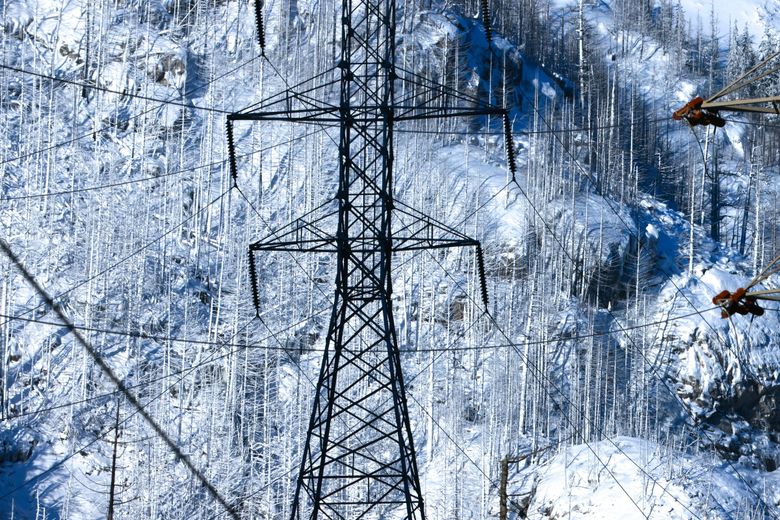
Snow-dusted foothills form a backdrop for high-voltage transmission lines around Newhalem in the North Cascades. (Karen Ducey / The Seattle Times)
Pacific Northwest climate change predictions
Drinking water and hydropower might be among the most noticeable ways people in the Pacific Northwest must adapt to climate change, but in reality no facet of life in the region will be untouched.
Agricultural experts and water managers speak of changing crops, investing in water-efficient irrigation tactics and guarding against drought. During the drought of 2015, farmers lost an estimated $335 million.
State and local officials will have to fine-tune their accounting systems to better track who draws water and in what quantities. For generations the resource was so plentiful here that a more stringent accounting system — like those found in the American Southwest — was never needed, said Ria Berns, who manages the state Department of Ecology’s Water Resources Program.
At the same time, decreasing snowfall will give way to heavier, repeated rainstorms, exacerbating flood risk across the state, sometimes with deadly consequences.
Don’t forget the creatures and things that can’t speak for themselves, said Scott Schuyler, natural resources policy representative for the Upper Skagit Indian Tribe. The natural environment depends on this water, too, and increasing drought will lead to more wildfires and dwindling biodiversity.
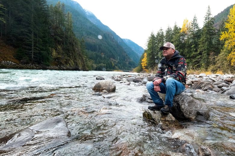
Scott Schuyler, natural resources policy representative for the Upper Skagit Tribe, sits on a rock on the bank of the Skagit River near the Diablo Dam. “Clean, cold water is the foundation of our very... (Karen Ducey / The Seattle Times)
Low summer streamflows mean fewer spawning locations and spiking temperatures, both of which will continue to kill the state’s salmon, Schuyler said.
Everything is connected, he said.
“Clean, cold water is the foundation of our very lives,” Schuyler said. “Unfortunately the human race has taken it for granted these last few decades.”
Conrad Swanson: 206-464-3805 or cswanson@seattletimes.com; Conrad covers climate change and its intersection with environmental and political issues. |
|


