Westgold Resources: Fortnum Expansion Study - Starlight Updated Mineral Resource Estimate of 12.9Mt @ 2.7g/t Au for 1.13Moz(1) highlights potential 10-year project life
newswire.ca
News provided by Westgold Resources Limited Dec 16, 2024, 20:25 ET
PERTH, Australia, Dec. 17, 2024 /CNW/ - Westgold Resources Limited (ASX: WGX) (TSX: WGX) (OTCQX: WGXRF) – (Westgold or the Company) is undertaking a portfolio asset review and is pleased to provide the summary of a Scoping Study evaluating the potential expansion of the Fortnum Gold Operation, 140km north of Meekatharra in the Murchison Region of Western Australia.
Scoping Study Summary
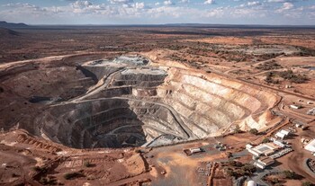
Figure 1 – Starlight mine overview (CNW Group/Westgold Resources Limited)
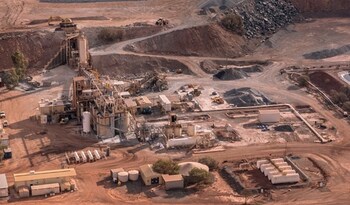
Figure 2 – Fortnum Processing Plant (CNW Group/Westgold Resources Limited)
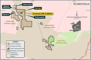
Figure 3 – Westgold’s Bryah asset map (CNW Group/Westgold Resources Limited)
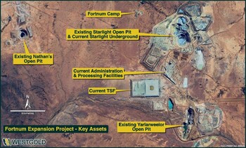
Figure 4 – Fortnum Expansion Project key assets (CNW Group/Westgold Resources Limited)
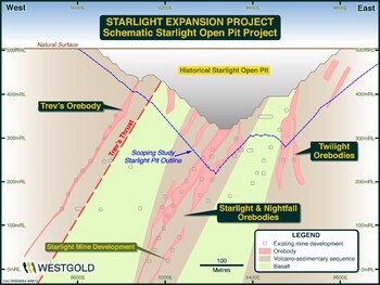
Figure 5 – Proposed Starlight open pit schematic extents. (CNW Group/Westgold Resources Limited)
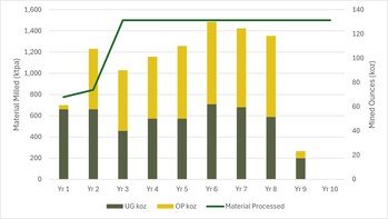
Figure 6 – Mid-point metal breakdown by year (CNW Group/Westgold Resources Limited)
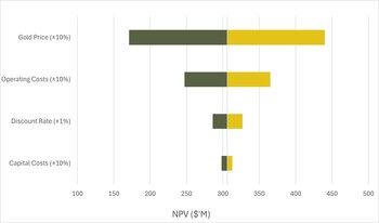
Figure 7 – Fortnum Scoping Study sensitivities (CNW Group/Westgold Resources Limited)

Fortnum Expansion Study (CNW Group/Westgold Resources Limited)
| Scoping Study on the Fortnum Expansion Project (FXP) has identified a potential 10-year, fully integrated mine plan
- Including the Starlight, Nathan's and Yarlarweelor open pits and an expansion of the existing Starlight underground operation
|
| Scoping Study underpinned by expanded Starlight Mineral Resource Estimate
- Now 12.9Mt at 2.7g/t Au for 1.13Moz of gold - 91% increase in the previously reported Starlight Mineral Resource Estimate (refer ASX – 16 September 2024 Mineral Resource Estimate and Ore Reserves).
|
| Scoping Study evaluates potential mill expansion – from current 0.9Mtpa to 1.5Mtpa, significantly reducing mill operating cost/tonne.
|
| Key Scoping Study outputs include:
- Life of Mine (LOM) gold production of 713koz – 871koz – at an All in Sustaining Cost range of $1,404 – $2,916/oz.
- Reduction in mid-point AISC to $1,558/oz once steady state is achieved
- Mid-point net present value (NPV8) of $306M at $3,500/oz
- lifting to NPV8 of $498M at current spot pricing of $4,000/oz.
- Mid-point free cash flow of $777M at $3,500/oz
- lifting to $1.2B at spot price of $4,000/oz
- Mid-point maximum cash drawdown of $53M - in year 2 of the project
- Mid-point total Life of Mine (10 year) Capital investment of $294M
|
___________________
| See ASX announcement dated 13 November 2024 titled 'Starlight Mineral Resource Grows by 91%'.
|
Cautionary Statement
The Scoping Study referred to in this ASX release has been undertaken to evaluate the potential expansion of the Fortnum Gold Operation (Fortnum), located approximately 150km north of the township of Meekatharra, Western Australia. Westgold owns 100% of Fortnum and is the operator of the Project.
The Scoping Study is prepared on a 100% basis and is a preliminary technical and economic study of the potential viability of the expanded Fortnum Gold Operation. It is based on technical and economic assessments that are sufficient to support estimation of Ore Reserves reported for the currently operating Fortnum Gold Operation which are included within the Fortnum Expansion Project (FXP) production schedule. Further infill drilling, evaluation work and appropriate studies are required before Westgold will be able to estimate complete Ore Reserves for the FXP or to provide assurance of an economic development case. The Scoping Study has been completed to a level of accuracy of +/- 35% for Operating costs, Capital costs and financial outcomes, and +/- 10% for production outcomes.
Of the Mineral Resources scheduled for extraction in this Scoping Study production target, approximately 8% is classified as Measured, 56% Indicated and 36% as Inferred over the evaluation period. There is a low level of geological confidence associated with Inferred Mineral Resources, and there is no certainty that further exploration work will result in the determination of Indicated Mineral Resources for the current Inferred portion, or that the production target itself will be realised.
100% of the current Starlight and Nathan's Ore Reserves (36% Proven and 64% Probable) are scheduled for extraction in this Scoping Study production target. Ore Reserves form 17% of the material currently scheduled for extraction in this Scoping Study production target. The Scoping Study production contemplates mining the existing Ore Reserves at Starlight underground and Nathan's open pit initially, before moving onto Indicated and Inferred Mineral Resources at Starlight underground and Nathan's, Starlight, Yarlarweelor and satellite open pits.
The Fortnum Gold Operation has been mined successfully over four main campaigns since discovery during the 1980's, with approximately 800koz Au produced from the main Starlight group of deposits. Westgold has undertaken open pit mining previously at Yarlarweelor and is currently mining Starlight underground and as such the Company has a reasonable degree of confidence in the projected production and commercial outcomes.
Furthermore, Westgold confirms that the FXP is financially viable at a Scoping level of accuracy when excluding Inferred Resources from the production schedule. The Company believes that it has a reasonable basis for providing these forward-looking statements and the forecast financial information based on material assumptions outlined in this release. While the Company considers all the material assumptions used in the Scoping Study to be based on reasonable grounds, there is no certainty that they will prove to be correct or that the range of outcomes indicated by the Scoping Study will be achieved.
One of the key assumptions is that the funding for the FXP will be available when required. To achieve the range of outcomes indicated in the Scoping Study, funding of approximately $294M will likely be required over the life of the project (circa 10 years), comprising approximately $39M in open pit pre-production capital expenditure, approximately $93M in processing plant capital including additional grinding capacity, expanded cyclone classification, additional leaching tanks and upgrades to the power system, approximately $113M in Life of Mine underground capital development, and approximately $48M in working capital and exploration funding. All above figures represent mid-point values.
Westgold has operating cashflow from its existing operations the Company, as at 30 September 2024 had $103M of cash, bullion and liquid investments (refer ASX – 31 October 2024, September 2024 Quarterly Results). Westgold also has optionality over debt to fund expansion projects and subsequent to the end of the quarter, on 28 October 2024 Westgold announced it had executed a commitment letter with its existing lenders to increase its $100 million Syndicated Facility Agreement to $300 million through the addition of a new $200M facility. Post quarter end, Westgold drew down $50 million of the facility.
Given the uncertainties involved, investors should not make any investment decisions based solely on the results of the Scoping Study.
Westgold Managing Director and CEO Wayne Bramwell commented:
"Westgold's review of its expanded portfolio of assets to determine where the best opportunities exist to enhance profitability is advancing, with the Fortnum Expansion Study the first to be completed.
Fortnum is a mature, yet under drilled asset and is one of Westgold's most profitable and productive operations, with the Starlight mine having produced over 800koz of gold over its life. The scoping study contemplates a modest upfront capital investment to deliver a long life, fully integrated open pit and underground project of increased scale, supported by an expansion of our existing processing plant to 1.5Mtpa.
Given Fortnum is currently operational many of the assumptions utilised in the Scoping Study are considered materially derisked by the Company and having passed this stage gate, our technical team will accelerate open pit drilling across Fortnum and Peak Hill as the next step of project evaluation."
Westgold's Fortnum Project – An Overview
Westgold's Fortnum Project is located approximately 140km north of Meekatharra, Western Australia and encompass the 0.9 Mtpa Fortnum processing plant and the Fortnum, Horseshoe and Peak Hill mining areas [Figure 3].
The Starlight underground mine is currently the predominant feed source (90% of all processed tonnes with the additional 10% of ore sourced from surface stockpiles) to Westgold's Fortnum processing hub.
Homestake Gold Mines (Homestake) developed the Fortnum mineral field during the 1980's, after regional reconnaissance work discovered gold mineralisation in outcrop at Tom's Hill. The Trev's, Dougie's and Twilight gold deposits (all part of the Starlight Mineralisation Complex) were mined as open pits by Homestake from 1989 to 1993.
In total ˜525,000 ounces of gold were produced historically from Starlight at ˜3.1g/t Au to a total depth of 260m by previous open pit and shallow underground operators (+2,000 ounces per vertical metre) before mining ceased.
Between 1994 and 1998 Perilya Gold Mines subsequently mined the Trev's – Starlight open pits, then the Starlight-Twilight underground from 1999 to 2001.
Westgold has subsequently mined +307koz from the Starlight underground.
Fortnum Expansion Plan (FXP) – Summary
The FXP Scoping Study contemplates a significant increase in output when compared to the current Fortnum Gold Operation which produced 58,752oz of gold at an AISC of $1,883 during FY24 (refer ASX – 23 October 2024 Annual Report). This output was achieved from one active mine, being the mainstay Starlight underground operation.
The FXP Scoping Study contemplates production of circa 83koz of gold per annum at an average all-In Sustaining Cost of approximately $2,160/oz (over the life of project). Production would be underpinned from three large open pits at Nathan's, Starlight and Yarlarweelor and a larger Starlight underground mine.
The existing 0.9Mtpa processing plant would be expanded to circa 1.5Mtpa with long-term tailings disposal into the Nathan's open pit void post mining. Subsequently a newly constructed paddock-style tailings storage facility (TSF) may be required.
This re-evaluation of the Fortnum asset is underpinned by the significant increase in the Mineral Resource Estimate for the Starlight deposit - now a total of 12.9Mt at 2.7g/t Au for 1.13Moz, a 91% increase in the previously reported Starlight Mineral Resource Estimate (refer ASX – 16 September 2024 Mineral Resource Estimate and Ore Reserves).
Westgold has undertaken a significant body of technical work to understand mineralisation distribution and grade variability. This in turn has driven a strategic review of the Fortnum operation, culminating in the Scoping Study which forms the basis of this release. The results of these studies have determined that total extraction of the mineralisation package represents the best balance between commercial result and certainty of outcome for the Starlight mine.
Mineral Resource Update
Over the last two years Westgold has invested significant resources into extending the footprint of the mineralised system at Starlight, with three drill rigs employed underground near-continually over this period.
Given the geological and geometric complexity at Starlight it is important to take a disciplined approach to drilling at the mine, striking a balance between defining the limits of the mineralised zone to allow efficient capital infrastructure placement, whilst at the same time acquiring enough infill information to allow for a sufficient level of robustness and certainty at the detailed mine planning and execution stage.
At the end of FY24 Westgold was able to incorporate a large portion of this drilling into a Mineral Resource Estimate update which delivered a 41% Mineral Resource increase compared to the FY23 Starlight Mineral Resource (refer ASX 11 June 2024 Starlight Mineral Resource Increases by 41%). This increase formed the basis of the studies considering project scale, differing estimation methodologies and a more complete extraction of the Mineral Resource that drove the current Scoping Study.
Table 1 – End of FY24 Starlight Mineral Resource Estimate
Starlight Mineral Resource Estimate
| Classification
| Tonnes (t)
| Grade (g/t Au)
| Ounces (Au)
| Measured
| 864,000
| 4.0
| 111,000
| Indicated
| 1,976,000
| 3.4
| 219,000
| Inferred
| 2,588,000
| 3.1
| 260,000
| Total
| 5,428,000
| 3.4
| 590,000
|
Subsequent to the end of FY24 Mineral Resource Estimate, and associated studies, the current Starlight Mineral Resource Estimate was conducted. The current process considers:
- Incorporation of additional drilling results acquired between estimates.
- Depletion for mining between estimates.
- A change in domaining approach and estimation methodology (from internal to the mineralised package sub-domaining with ordinary Kriging to a more holistic mineralised package domaining approach and Categorical Indicator Kriging).
- A change in extraction philosophy to that of a more comprehensive extraction of Mineral Resource base.
- The consideration of an open pit mining phase.
- Change in project and processing scale lowering the unit cost base and subsequent cut-off grade calculations.
The resultant Mineral Resource Estimate now stands at 12.9Mt at 2.7g/t Au for 1.13Moz of gold, a 91% increase as tabulated below (Tables 2, 3 and 4).
Table 2 – Current Starlight Open Pit Mineral Resource Estimate – reported above a $4,000/oz open pit shell and above 0.5g/t Au
Starlight Open Pit Mineral Resource Estimate
| Classification
| Tonnes (t)
| Grade (g/t Au)
| Ounces (Au)
| Measured
| 400,000
| 2.7
| 40,000
| Indicated
| 2,500,000
| 1.8
| 140,000
| Inferred
| 1,300,000
| 2.7
| 110,000
| Total
| 4,200,000
| 2.2
| 290,000
|
Table 3 – Current Starlight Underground Mineral Resource Estimate – reported below a $4,000/oz open pit shell and above 1.2g/t Au
Starlight Underground Mineral Resource Estimate
| Classification
| Tonnes (t)
| Grade (g/t Au)
| Ounces (Au)
| Measured
| 600,000
| 3.7
| 70,000
| Indicated
| 4,000,000
| 2.8
| 370,000
| Inferred
| 4,100,000
| 3.1
| 400,000
| Total
| 8,700,000
| 3.0
| 840,000
|
Table 4 – Current Starlight Mineral Resource Estimate – combined open pit and underground portions
Total Starlight Mineral Resource Estimate
| Classification
| Tonnes (t)
| Grade (g/t Au)
| Ounces (Au)
| Measured
| 1,000,000
| 3.3
| 100,000
| Indicated
| 6,500,000
| 2.4
| 510,000
| Inferred
| 5,400,000
| 3.0
| 510,000
| Total
| 12,900,000
| 2.7
| 1,130,000
|
The background to the Mineral Resource Estimate is provided as Appendix 1.
FXP Scoping Study Summary
Note that all Scoping Study figures represented here are mid-point values. Appropriate ranges are provided in Tables 5 through 8 below.
- Average gold production of approximately 83koz per annum (an increase of ~25koz) - with an average gold head grade of 2.0g/t Au for total gold production of approximately 832koz over a 10-year Life of Mine (LoM).
- First two years underpinned by current Starlight underground mine plan - and a significant open pit at Nathan's.
- Major Starlight open pit program initiated in year two - and development of an expanded underground to occur simultaneously from adjacent location.
- Major Yarlarweelor open pit plus minor satellite pits - commence year six.
- Over the LoM an average All-In Sustaining Cost (AISC) of approximately $2,160/oz.
- Reduction in mid-point AISC to $1,550/oz once steady state is achieved - higher in early periods with both underground and open pits starting.
- LoM Mining (UG): $1,270/oz.
- LoM Mining (OP): $1,559/oz.
- LoM Processing: $507/oz.
- LoM G&A: $193/oz.
- Scoping Study assumes an upgrade of the 0.9Mtpa carbon-in-leach (CIL) plant to 1.5Mtpa - to process the increased material mined through both the Starlight underground and regional open pit program.
- Total life of mine capital of approximately $294M:
- Capital costs to upgrade current 0.9Mtpa processing plant to 1.5Mtpa of approximately $93M including additional crushing and grinding capacity, expanded cyclone classification, additional leaching tanks and upgrades to the power system.
- Open pit and underground capital of approximately $152M.
- Working capital (such as tails dams, closure costs) of approximately $48M.
- Capital intensity of approximately $525/oz reflects low capital nature of the project.
- Compelling financial outcomes reflecting the low capital intensity of the FXP.
- Project life of 10-years.
- Pre-tax undiscounted cashflow of approximately $777M over the LoM at a gold price of $3,500/oz - increasing to $1.2B at spot gold price ($4,000/oz).
- Net Present Value (NPV8) of approximately $306M at a gold price of $3,500/oz - increasing to $498M at spot gold price ($4,000/oz).
Key Study Outcomes and Assumptions
Westgold has considered various options within the FXP, such as development of the Starlight underground only, smaller open pit cutbacks to maximise grade, and heap leach. The FXP as defined in this release has a modest capital requirement and maximises project cashflow from open pit and existing underground mining sources.
The Scoping Study assumes truck and shovel open pit mining will be completed within the Starlight, Yarlarweelor, and Nathan's pits. Cut-backs on these pits have been assumed utilising current costs supplied by external operators alongside Westgold's own internal costing regime. Wall angles, bench heights, and berm widths are based on a mixture of historical mining within these pits as well as geotechnical recommendations supplied by external consultants. Dilution and ore loss aligns with historic mining within the area.
Underground mining utilises a method and modifying factors associated with the current underground Starlight mine.
Minimum mining widths, cut-off grades, stope sizes, dilution and ore loss are all included within the Scoping Study and based on those being achieved within the existing Starlight underground operation.
Given Fortnum is an operating mine, Westgold assumes that a transition from the current operational plan could occur during FY26, if the next phase of evaluation supported a Final Investment Decision (FID).
Table 5 – Key physical assumptions
Assumptions
| Life of Mine
| Years
| 10.0
| Plant Throughput
| ktpa
| 1,500
| Combined Mine Output
| Material Mined
| kt
| 12,757 – 15,591
| Au Grade
| g/t
| 1.8 – 2.2
| Au Ounces
| koz
| 822 – 1,004
| Total Open Pit
| Material Mined
| kt
| 6,281 – 7,677
| Au Grade
| g/t
| 1.5 – 1.9
| Au Ounces
| koz
| 399 - 487
| Total Underground
| Material Mined
| kt
| 5,405 – 6,607
| Au Grade
| g/t
| 2.2 – 2.6
| Au Ounces
| koz
| 423 - 517
| Processing Physicals
| Material Processed
| kt
| 11,687 – 14,284
| Au Grade
| g/t
| 1.8 – 2.2
| Au Ounces
| koz
| 752 - 919
| Payable Metal (post processing recovery)
| koz
| 713 - 871
|
A conservative gold price of $3,500/oz (significantly lower than the spot gold price at $4,000/oz), has been used to determine the economic viability of the FXP. The project is forecast to generate a healthy unleveraged NPV8 of approximately $306M.
The financial summary is shown below:
Table 6 – Financial results summary
Financials @ 8% Discount Factor
| Gold Price
| $/oz
| 3,500
| 4,000
| Project Valuation
| Project Free Cash flow pre-tax
| $m
| 505 –1,049
| 775 – 1,610
| Project NPV
| $m
| 198 - 413
| 324 - 672
| Maximum cash out
| $m
| 34 - 70
| 23 - 49
| AISC margin
| $oz
| 1,404 – 2,916
| 1,411 – 2,932
|
Total payable metal over the life of the project is forecast to be approximately 832koz, an annualised breakdown is shown below [Figure 6].
Current projections of mined material exceed the FXP processing capacity at 1.5Mtpa and hence comparative studies on processing size optimisation will be completed within a Pre-Feasibility Study (PFS). For the Scoping Study it is assumed excess stockpiles will be available to be processed at the cessation of mining.
Sensitivity Analysis
The project NPV is most sensitive to changes in gold price and operating costs as shown in Figure 7, below whilst being more resilient to changes in the discount rate and capital costs.
Capital Costs
Capital cost estimates are derived from several sources, including quotes, budget pricing and actual prices from suppliers to Westgold's current operating mines. Estimated Capital items include expansion capital for open pit mining, processing plant, tailings dams, pre-production underground development, dewatering, and sustaining capital post the commencement of production.
Westgold has taken a conservative approach to its capital estimation and is of the view that substantial opportunities exist to reduce and defer elements of pre-production capital. These opportunities are subject to further study in accordance with Westgold's Capital Allocation Framework.
Table 7 – Capital cost estimates
Expansion Capital
| Site Infrastructure
| $m
| 37 - 77
| Tails Storage
| $m
| 8 - 16
| Processing Facilities
| $m
| 60 - 126
| Underground Development
| $m
| 17 - 35
| Open Pit
| $m
| 25 - 53
| Total Pre-Production
| $m
| 148 - 306
| Sustaining Capital – LoM
| Underground
| $m
| 37 – 77
| Other
| $m
| 7 – 14
| Total
| $m
| 44 – 90
|
Operating Cost
Operating costs are derived from several sources including quotations and budget pricing alongside Westgold's own existing cost profile.
Table 8 – Operating cost estimates
Operating Costs
| Mining
| $m
| 794 – 1,648
| Processing
| $m
| 266 - 552
| Site G&A
| $m
| 101 - 211
| Royalty
| $m
| 47 - 97
| Total Operating Costs
| $m
| 1,208 – 2,508
|
Looking Forward
The current FXP Scoping Study defines a commercially viable alternative to enhance Fortnum Project physical and economic outputs. The study depicts attractive financial and production metrics with a modest capital requirement and as such, the FXP warrants further evaluation.
Given Fortnum is currently operational many of the assumptions utilised in the Scoping Study are considered materially derisked by the Company, and thus Westgold has resolved to advance drilling across the open pit targets across the Fortnum and Peak Hill tenure.
A Pre-Feasibility Study will include detailed design optimisation and scheduling in an effort to improve commercial metrics, consideration of satellite mining opportunities to further underwrite the significant Life of Mine (inclusive of Yarlarweelor underground studies), and the commencement of surface resource development drilling to improve definition of the mineralised system within the proposed open pits, expanded underground footprints as well as additional development targets.
Fortnum in its expanded form appears significantly value accretive for the enlarged Westgold. Fortnum's strong recent operational and commercial performance and the relative simplicity of the FXP plan provide the Company with confidence that it can bring the project to an Investment Decision within 12 months, in accordance with its Capital Allocation Framework.
Westgold looks forward to providing an update on the progress of the Fortnum Expansion Project during calendar year 2025 (CY25).
This announcement is authorised for release by the Board of Directors.
Competent Person Statements
Mineral Resource Estimates
The information in this report that relates to Mineral Resource Estimates is compiled by Westgold technical employees and contractors under the supervision of Mr. Jake Russell B.Sc. (Hons), who is a member of the Australian Institute of Geoscientists. Mr Russell is a full-time employee of the company and has sufficient experience which is relevant to the styles of mineralisation and types of deposit under consideration and to the activities which he is undertaking to qualify as a Competent Person as defined in the 2012 Edition of the 'Australasian Code for Reporting of Exploration Results, Mineral Resources and Ore Reserves'. Mr Russell consents to the inclusion in this report of the matters based on his information in the form and context in which it appears. Mr Russell is eligible to participate in short- and long-term incentive plans of the company.
Ore Reserves
The information in this report that relates to Ore Reserve is based on information compiled by Mr. Leigh Devlin B.Eng. FAusIMM. Mr. Devlin has sufficient experience which is relevant to the styles of mineralisation and types of deposit under consideration and to the activities which they are undertaking to qualify as a Competent Person as defined in the 2012 Editions of the 'Australasian Code for Reporting of Exploration Results, Mineral Resources and Ore Reserves'. Mr. Devlin consents to the inclusion in this report of the matters based on his information in the form and context in which it appears. Mr. Devlin is a full-time senior executive of the Company and is eligible to and may participate in short-term and long-term incentive plans of the Company as disclosed in its annual reports and disclosure documents.
Forward looking statements
These materials prepared by Westgold Resources Limited include forward looking statements. Often, but not always, forward looking statements can generally be identified by the use of forward looking words such as "may", "will", "expect", "intend", "believe", "forecast", "predict", "plan", "estimate", "anticipate", "continue", and "guidance", or other similar words and may include, without limitation, statements regarding plans, strategies and objectives of management, anticipated production or construction commencement dates and expected costs or production outputs.
Forward looking statements inherently involve known and unknown risks, uncertainties and other factors that may cause the Company's actual results, performance and achievements to differ materially from any future results, performance or achievements. Relevant factors may include, but are not limited to, changes in commodity prices, foreign exchange fluctuations and general economic conditions, increased costs and demand for production inputs, the speculative nature of exploration and project development, including the risks of obtaining necessary licenses and permits and diminishing quantities or grades of reserves, political and social risks, changes to the regulatory framework within which the Company operates or may in the future operate, environmental conditions including extreme weather conditions, recruitment and retention of personnel, industrial relations issues and litigation.
Forward looking statements are based on the Company and its management's good faith assumptions relating to the financial, market, regulatory and other relevant environments that will exist and affect the Company's business and operations in the future. The Company does not give any assurance that the assumptions on which forward looking statements are based will prove to be correct, or that the Company's business or operations will not be affected in any material manner by these or other factors not foreseen or foreseeable by the Company or management or beyond the Company's control.
Although the Company attempts and has attempted to identify factors that would cause actual actions, events or results to differ materially from those disclosed in forward looking statements, there may be other factors that could cause actual results, performance, achievements or events not to be as anticipated, estimated or intended, and many events are beyond the reasonable control of the Company. In addition, the Company's actual results could differ materially from those anticipated in these forward looking statements as a result of the factors outlined in the "Risk Factors" section of the Company's continuous disclosure filings available on SEDAR+ or the ASX, including, in the Company's current annual report, half year report or most recent management discussion and analysis.
Accordingly, readers are cautioned not to place undue reliance on forward looking statements. Forward looking statements in these materials speak only at the date of issue. Subject to any continuing obligations under applicable law or any relevant stock exchange listing rules, in providing this information the Company does not undertake any obligation to publicly update or revise any of the forward-looking statements or to advise of any change in events, conditions or circumstances.
Reasonable Basis for Forward-Looking Statements
This ASX release has been prepared in compliance with the JORC Code (2012) and the ASX Listing Rules. All material assumptions on which the Scoping Study production target and projected financial information are based have been included in this release.
Consideration of Modifying Factors in the format specified by JORC Code (2012) is provided in Section 4.
Appendix A – Background to the Mineral Resource Estimate
The Fortnum deposits are Paleoproterozoic shear-hosted gold deposits within the Fortnum Wedge, a localised thrust duplex of Narracoota Formation within the overlying Ravelstone Formation. Both stratigraphic formations comprise part of the Bryah Basin in the Capricorn Orogen, Western Australia.
Geological interpretation of individual deposits is carried out using a systematic approach to ensure that the resultant estimated Mineral Resource Estimate was both sufficiently constrained, and representative of the expected sub-surface conditions. In all aspects of Mineral Resource Estimation, the factual and interpreted geology was used to guide the development of the interpretation. Geological matrixes were established to assist with interpretation and construction of the estimation domains.
A significant portion of the data used in Mineral Resource Estimations has been gathered from diamond core drilling. Multiple core sizes have been used. This core is geologically logged and subsequently halved for sampling. Grade control holes may be whole-cored to streamline the core handling process if required. Face sampling data is also utilised, where each development face / round is horizontally chip sampled. The sampling intervals are domained by geological constraints (e.g. rock type, veining and alteration / sulphidation etc.).
In the near surface environment RC drilling dominates the data informing Mineral Resource Estimations.
All geology input is logged and validated by the relevant area geologists, incorporated into this is assessment of sample recovery. No defined relationship exists between sample recovery and grade. Nor has sample bias due to preferential loss or gain of fine or coarse material been noted.
Faces are nominally chipped horizontally across the face from left to right, sub-set via geological features as appropriate. Diamond drilling is half-core niche sampled, sub-set via geological features as appropriate.
Samples undergo fine pulverisation of the entire sample by an LM5 type mill to achieve a 75 µ product prior to splitting. QA/QC is currently ensured during the sub-sampling stages process via the use of the systems of an independent NATA / ISO accredited laboratory contractor. The sample size is considered appropriate for the grain size of the material being sampled. The un-sampled half of diamond core is retained for check sampling if required.
Sampling is analysed for gold by fire assay as outlined below;
- A 40g – 50g sample undergoes fire assay lead collection followed by flame atomic adsorption spectrometry.
- Independent quality control is ensured via the use of standards, blanks and duplicates. Additionally, the laboratory includes a minimum of 1 project standard with every 22 samples analysed. No significant quality assurance or quality control issues have arisen in recent drilling results.
After validating the drillhole data to be used in the estimation, interpretation of the orebody is undertaken to create the outline strings which form the basis of the three-dimensional orebody wireframe. Wireframing is then carried out using a combination of automated stitching algorithms and manual triangulation to create an accurate three-dimensional representation of the sub-surface mineralised body.
Drillhole intersections within the mineralised body are defined, these intersections are then used to flag the appropriate sections of the drillhole database tables for compositing purposes. Drillholes are subsequently composited to allow for grade estimation. In all aspects of resource estimation, the factual and interpreted geology was used to guide the development of the interpretation.
Once the sample data has been composited, a statistical analysis is undertaken to assist with determining estimation search parameters, top-cuts etc. Analysis of individual domains is undertaken to assist with determining appropriate search parameters. Which are then incorporated with observed geological and geometrical features to determine the most appropriate search parameters.
An empty block model is then created for the area of interest. This model contains attributes set at background values for the various elements of interest as well as density, and various estimation parameters that are subsequently used to assist in resource categorisation. The block sizes used in the model will vary depending on orebody geometry, minimum mining units, estimation parameters and levels of informing data available.
Grade estimation is then undertaken. The distribution of gold grades within the mineralised lodes is highly variable and is characterised by cohesive regions of higher tenor gold grades, with clusters of individual values often reaching over eighty grams per tonne. Whilst these higher-grade zones appear reasonably cohesive, they are manifested by a high-degree of short-scale variability, making it difficult to manually interpret constraining domains. These internal, high-grade regions are often surrounded by peripheral regions of lower grade mineralisation that is also highly variable.
The moderate to high grade variability and complex spatial continuity supports the use of Categorical Indicator Kriging (CIK) to define internal estimation sub-domains domains, together with applying distance limiting at chosen grade thresholds to restrict the influence of the high grade and extreme grade values during grade interpolation.
Estimation results were validated against primary input data, previous estimates and mining output.
The Mineral Resource is then depleted for mining voids and subsequently classified in line with JORC guidelines utilising a combination of various estimation derived parameters and geological / mining knowledge.
Data spacing is variable dependent upon the individual lode under consideration.
This approach considers all relevant factors and reflects the Competent Person's view of the deposit.
The cut off grades used for the reporting of the Mineral Resources Estimates is selected based upon the style of mineralisation, depth from surface of the mineralisation and the most probable extraction technique and associated costs.
Likely mining approaches have been considered at the domaining, estimation and classification steps. However, no mining dilution or ore loss has been modelled in the resource model or applied to the reported Mineral Resource Estimate. Nor has metallurgical recovery been applied to the reported Mineral Resource Estimate. These factors are applied during the Ore Reserve generation process.
Appendix B – JORC 2012 Table 1– Gold Division
SECTION 1: SAMPLING TECHNIQUES AND DATA
(Criteria in this section apply to all succeeding sections.)
Criteria
| JORC Code Explanation
| Commentary
| Sampling techniques
Drilling techniques
Drill sample recovery
|
- Nature and quality of sampling (e.g. cut channels, random chips, or specific specialised industry standard measurement tools appropriate to the minerals under investigation, such as down hole gamma sondes, or handheld XRF instruments, etc.). These examples should not be taken as limiting the broad meaning of sampling.
- Include reference to measures taken to ensure sample representivity and the appropriate calibration of any measurement tools or systems used.
- Aspects of the determination of mineralisation that are Material to the Public Report.
- In cases where 'industry standard' work has been done this would be relatively simple (e.g. 'reverse circulation drilling was used to obtain 1 m samples from which 3 kg was pulverised to produce a 30 g charge for fire assay'). In other cases more explanation may be required, such as where there is coarse gold that has inherent sampling problems. Unusual commodities or mineralisation types (e.g. submarine nodules) may warrant disclosure of detailed information.
- Drill type (e.g. core, reverse circulation, open-hole hammer, rotary air blast, auger, Bangka, sonic, etc.) and details (e.g. core diameter, triple or standard tube, depth of diamond tails, face-sampling bit or other type, whether core is oriented and if so, by what method, etc.).
- Method of recording and assessing core and chip sample recoveries and results assessed.
- Measures taken to maximise sample recovery and ensure representative nature of the samples.
- Whether a relationship exists between sample recovery and grade and whether sample bias may have occurred due to preferential loss/gain of fine/coarse material.
|
- Diamond Drilling
- A significant portion of the data used in resource calculations has been gathered from diamond core. Multiple sizes have been used historically. This core is geologically logged and subsequently halved for sampling. Grade control holes may be whole-cored to streamline the core handling process if required.
- Face Sampling
- At each of the major past and current underground producers, each development face / round is horizontally chip sampled. The sampling intervals are domained by geological constraints (e.g. rock type, veining and alteration / sulphidation etc.). The majority of exposures within the orebody are sampled.
- Sludge Drilling
- Sludge drilling at is performed with an underground production drill rig. It is an open hole drilling method using water as the flushing medium, with a 64mm (nominal) hole diameter. Sample intervals are ostensibly the length of the drill steel. Holes are drilled at sufficient angles to allow flushing of the hole with water following each interval to prevent contamination. Sludge drilling is not used to inform resource models.
- RC Drilling
- Drill cuttings are extracted from the RC return via cyclone. The underflow from each interval is transferred via bucket to a four-tiered riffle splitter, delivering approximately three kilograms of the recovered material into calico bags for analysis. The residual material is retained on the ground near the hole. Composite samples are obtained from the residue material for initial analysis, with the split samples remaining with the individual residual piles until required for re-split analysis or eventual disposal.
- RAB / Aircore Drilling
- Combined scoops from bucket dumps from cyclone for composite. Split samples taken from individual bucket dumps via scoop. RAB holes are not included in the resource estimate.
- Blast Hole Drilling
- Cuttings sampled via splitter tray per individual drill rod. Blast holes not included in the resource estimate.
- All geology input is logged and validated by the relevant area geologists, incorporated into this is assessment of sample recovery. No defined relationship exists between sample recovery and grade. Nor has sample bias due to preferential loss or gain of fine or coarse material been noted.
| Logging
|
- Whether core and chip samples have been geologically and geotechnically logged to a level of detail to support appropriate Mineral Resource estimation, mining studies and metallurgical studies.
- Whether logging is qualitative or quantitative in nature. Core (or costean, channel, etc.) photography.
- The total length and percentage of the relevant intersections logged
|
- Westgold surface drill-holes are all orientated and have been logged in detail for geology, veining, alteration, mineralisation and orientated structure. Westgold underground drill-holes are logged in detail for geology, veining, alteration, mineralisation and structure. Core has been logged in enough detail to allow for the relevant mineral resource estimation techniques to be employed.
- Surface core is photographed both wet and dry and underground core is photographed wet. All photos are stored on the Company's servers, with the photographs from each hole contained within separate folders.
- Development faces are mapped geologically.
- RC, RAB and Aircore chips are geologically logged.
- Sludge drilling is logged for lithology, mineralisation and vein percentage.
- Logging is both qualitative and quantitative in nature.
- All holes are logged completely, all faces are mapped completely.
| Sub-sampling techniques and sample preparation
|
- If core, whether cut or sawn and whether quarter, half or all core taken.
- If non-core, whether riffled, tube sampled, rotary split, etc. and whether sampled wet or dry.
- For all sample types, the nature, quality and appropriateness of the sample preparation technique.
- Quality control procedures adopted for all sub-sampling stages to maximise representivity of samples.
- Measures taken to ensure that the sampling is representative of the in-situ material collected, including for instance results for field duplicate/second-half sampling.
- Whether sample sizes are appropriate to the grain size of the material being sampled.
|
- Blast holes -Sampled via splitter tray per individual drill rods.
- RAB / AC chips - Combined scoops from bucket dumps from cyclone for composite. Split samples taken from individual bucket dumps via scoop.
- RC - Three tier riffle splitter (approximately 5kg sample). Samples generally dry.
- Face Chips - Nominally chipped horizontally across the face from left to right, sub-set via geological features as appropriate.
- Diamond Drilling - Half-core niche samples, sub-set via geological features as appropriate. Grade control holes may be whole-cored to streamline the core handling process if required.
- Chips / core chips undergo total preparation.
- Samples undergo fine pulverisation of the entire sample by an LM5 type mill to achieve a 75µ product prior to splitting.
- QA/QC is currently ensured during the sub-sampling stages process via the use of the systems of an independent NATA / ISO accredited laboratory contractor. A significant portion of the historical informing data has been processed by in-house laboratories.
- The sample size is considered appropriate for the grain size of the material being sampled.
- The un-sampled half of diamond core is retained for check sampling if required. For RC chips regular field duplicates are collected and analysed for significant variance to primary results.
| Quality of assay data and laboratory tests
|
- The nature, quality and appropriateness of the assaying and laboratory procedures used and whether the technique is considered partial or total.
- For geophysical tools, spectrometers, handheld XRF instruments, etc., the parameters used in determining the analysis including instrument make and model, reading times, calibrations factors applied and their derivation, etc.
- Nature of quality control procedures adopted (e.g. standards, blanks, duplicates, external laboratory checks) and whether acceptable levels of accuracy (i.e. lack of bias) and precision have been established.
|
- Recent sampling was analysed by fire assay as outlined below;
- A 40g – 50g sample undergoes fire assay lead collection followed by flame atomic adsorption spectrometry.
- The laboratory includes a minimum of 1 project standard with every 22 samples analysed.
- Quality control is ensured via the use of standards, blanks and duplicates.
- No significant QA/QC issues have arisen in recent drilling results.
- Photon Assay was introduced in 2023 for Beta Hunt grade control samples. PhotonAssay™ technology (Chrysos Corporation Limited) is a rapid, non-destructive analysis of gold and other elements in mineral samples. It is based on the principle of gamma activation, which uses high energy x-rays to excite changes to the nuclear structure of selected elements. The decay is then measured to give a gold analysis. Each sample is run through two cycles with a radiation time of 15s. This methodology is insensitive to material type and thus does not require fluxing chemicals as in the fire assay methodology. Highlights of the PhotonAssay™ process are as follows:
- The process is non-destructive; the same sample accuracy can be determined by repeat measurements of the same sample. In addition, the instrument runs a precision analysis for each sample relating to the instrument precision.
- The process allows for an increased sample size, about 500 g of crushed product.
- The crushed material is not pulverised, as in the fire assay process; this ensures that gold is not smeared or lost during pulverisation (especially important if there is an expectation of visible gold that is being analysed)
- Historical drilling has used a combination of Fire Assay, Aqua Regia and PAL analysis.
- These assay methodologies are appropriate for the resources in question.
| Verification of sampling and assaying
|
- The verification of significant intersections by either independent or alternative company personnel.
- The use of twinned holes.
- Documentation of primary data, data entry procedures, data verification, data storage (physical and electronic) protocols.
- Discuss any adjustment to assay data.
|
- No independent or alternative verifications are available.
- Virtual twinned holes have been drilled in several instances across all sites with no significant issues highlighted. Drillhole data is also routinely confirmed by development assay data in the operating environment.
- Primary data is collected utilising LogChief. The information is imported into a SQL database server and verified.
- All data used in the calculation of resources and reserves are compiled in databases (underground and open pit) which are overseen and validated by senior geologists.
- No adjustments have been made to any assay data.
| Location of data points
|
- Accuracy and quality of surveys used to locate drill holes (collar and down-hole surveys), trenches, mine workings and other locations used in Mineral Resource estimation.
- Specification of the grid system used.
- Quality and adequacy of topographic control.
|
- All data is spatially oriented by survey controls via direct pickups by the survey department. Drillholes are all surveyed downhole, deeper holes with a Gyro tool if required, the majority with single / multishot cameras.
- All drilling and resource estimation is preferentially undertaken in local mine grid at the various sites.
- Topographic control is generated from a combination of remote sensing methods and ground-based surveys. This methodology is adequate for the resources in question.
| Data spacing and distribution
|
- Data spacing for reporting of Exploration Results.
- Whether the data spacing and distribution is sufficient to establish the degree of geological and grade continuity appropriate for the Mineral Resource and Ore Reserve estimation procedure(s) and classifications applied.
- Whether sample compositing has been applied.
|
- Data spacing is variable dependent upon the individual orebody under consideration. A lengthy history of mining has shown that this approach is appropriate for the Mineral Resource Estimation process and to allow for classification of the resources as they stand.
- Compositing is carried out based upon the modal sample length of each individual domain.
| Orientation of data in relation to geological structure
|
- Whether the orientation of sampling achieves unbiased sampling of possible structures and the extent to which this is known, considering the deposit type.
- If the relationship between the drilling orientation and the orientation of key mineralised structures is considered to have introduced a sampling bias, this should be assessed and reported if material.
|
- Drilling intersections are nominally designed to be normal to the orebody as far as underground infrastructure constraints / topography allows.
- Development sampling is nominally undertaken normal to the various orebodies.
- Where drilling angles are sub optimal the number of samples per drill hole used in the estimation has been limited to reduce any potential bias.
- It is not considered that drilling orientation has introduced an appreciable sampling bias.
| Sample security
|
- The measures taken to ensure sample security.
|
- For samples assayed at on-site laboratory facilities, samples are delivered to the facility by Company staff. Upon delivery the responsibility for sample security and storage falls to the independent third-party operators of these facilities.
- For samples assayed off-site, samples are delivered to a third-party transport service, who in turn relay them to the independent laboratory contractor. Samples are stored securely until they leave site.
| Audits or reviews
|
- The results of any audits or reviews of sampling techniques and data
|
- Site generated resources and reserves and the parent geological data is routinely reviewed by the Westgold Corporate technical team.
|
SECTION 2: REPORTING OF EXPLORATION RESULTS
(Criteria listed in the preceding section also apply to this section.)
Criteria
| JORC Code Explanation
| Commentary
| Mineral tenement and land tenure status
|
- Type, reference name/number, location and ownership including agreements or material issues with third parties such as joint ventures, partnerships, overriding royalties, native title interests, historical sites, wilderness or national park and environmental settings.
- The security of the tenure held at the time of reporting along with any known impediments to obtaining a licence to operate in the area.
|
- Native title interests are recorded against several WGX tenements.
- The CMGP tenements are held by the Big Bell Gold Operations (BBGO) of which Westgold has 100% ownership.
- Several third-party royalties exist across various tenements at CMGP, over and above the state government royalty.
- The Fortnum Gold Project tenure is 100% owned by Westgold through subsidiary company Aragon Resources Pty. Ltd. Various Royalties apply to the package. The most pertinent being;
- State Government – 2.5% NSR
- Beta Hunt is owned by Westgold through a sub-lease agreement with St Ives Gold Mining Company Pty Ltd (SIGMC), which gives Westgold the right to explore and mine gold and nickel.
- Royalties on gold production from Beta Hunt are as follows:
- A royalty to the state government equal to 2.5% of the royalty value of gold metal produced; and
- Royalties to third parties equal to 4.75% of recovered gold less allowable deductions.
- The Higginsville-Lakewood Operations include the Higginsville and Lakewood Mills and associated infrastructure, mining operations and exploration prospects which are located on 242 tenements owned by Westgold and covers approximately 1,800km2 total area.
- Royalties on the HGO gold production are as follows:
- Production payments of up to 1% of gross gold revenue over various tenements to traditional land owners.
- Royalty equal to 2.5% of recovered gold to the Government of Western Australia; and
- Various third parties hold rights to receive royalties in respect of gold (and in some cases other minerals or metals) recovered from the tenements.
- The tenure is currently in good standing.
- There are no known issues regarding security of tenure.
- There are no known impediments to continued operation.
- WGX operates in accordance with all environmental conditions set down as conditions for grant of the leases.
| Exploration done by other parties
|
- Acknowledgment and appraisal of exploration by other parties
|
- The CMGP tenements have an exploration and production history in excess of 100 years.
- The FGO tenements have an exploration and production history in excess of 30 years.
- BHO tenements have an exploration and production history in excess of 60 years.
- HGO tenements have an exploration and production history in excess of 40 years.
- Westgold work has generally confirmed the veracity of historic exploration data.
| Geology
|
- Deposit type, geological setting and style of mineralisation.
| BHO
- Beta Hunt is situated within the central portion of the Norseman-Wiluna greenstone belt in a sequence of mafic/ultramafic and felsic rocks on the southwest flank of the Kambalda Dome.
- Gold mineralisation occurs mainly in subvertical shear zones in the Lunnon Basalt and is characterised by shear and extensional quartz veining within a halo of biotite/pyrite alteration. Within these shear zones, coarse gold sometimes occurs where the shear zones intersect iron-rich sulphidic metasediments in the Lunnon Basalt or nickel sulphides at the base of the Kambalda Komatiite (ultramafics). The mineralised shears are represented by A-Zone, Western Flanks, Larkin and Mason zones.
|
|
| CGO
- CGO is located in the Achaean Murchison Province, a granite-greenstone terrane in the northwest of the Yilgarn Craton. Greenstone belts trending north-northeast are separated by granite-gneiss domes, with smaller granite plutons also present within or on the margins of the belts.
- Mineralisation at Big Bell is hosted in the shear zone (Mine Sequence) and is associated with the post-peak metamorphic retrograde assemblages. Stibnite, native antimony and trace arsenopyrite are disseminated through the K-feldspar-rich lode schist. These are intergrown with pyrite and pyrrhotite and chalcopyrite. Mineralisation outside the typical Big Bell host rocks (KPSH), for example 1,600N and Shocker, also display a very strong W-As-Sb geochemical halo.
- Numerous gold deposits occur within the Cuddingwarra Project area, the majority of which are hosted within the central mafic-ultramafic ± felsic porphyry sequence. Within this broad framework, mineralisation is shown to be spatially controlled by competency contrasts across, and flexures along, layer-parallel D2 shear zones, and is maximised when transected by corridors of northeast striking D3 faults and fractures.
- The Great Fingall Dolerite hosts the majority gold mineralisation within the portion of the greenstone belt proximal to Cue (The Day Dawn Project Area). Unit AGF3 is the most brittle of all the five units and this characteristic is responsible for its role as the most favourable lithological host to gold mineralisation in the Greenstone Belt.
|
|
| FGO
- The Fortnum deposits are Paleoproterozoic shear-hosted gold deposits within the Fortnum Wedge, a localised thrust duplex of Narracoota Formation within the overlying Ravelstone Formation. Both stratigraphic formations comprise part of the Bryah Basin in the Capricorn Orogen, Western Australia.
- The Horseshoe Cassidy deposits are hosted within the Ravelstone Formation (siltstone and argillite) and Narracoota Formation (highly altered, moderate to strongly deformed mafic to ultramafic rocks). The main zone of mineralisation is developed within a horizon of highly altered magnesian basalt. Gold mineralisation is associated with strong vein stock works that are confined to the altered mafic. Alteration consists of two types: stockwork proximal silica-carbonate-fuchsite-haematite-pyrite and distal silica-haematite-carbonate+/- chlorite.
- The Peak Hill district represents remnants of a Proterozoic fold belt comprising highly deformed trough and shelf sediments and mafic / ultramafic volcanics, which are generally moderately metamorphosed (except for the Peak Hill Metamorphic Suite).
|
|
| HGO
- The Higginsville Gold Operation is located in the Eastern Goldfields Superterrane of the Archean Yilgarn Craton. The bulk of the Higginsville tenement package is located almost entirely within the well-mineralised Kalgoorlie Terrane, between the gold mining centres of Norseman and St Ives. HGO can be sub-divided into seven major geological domains: Trident Line of Lode, Chalice, Lake Cowan, Southern Paleo-channels, Mt Henry, Polar Bear Group and Spargos Project area.
- Majority of mineralisation along the Trident Line of Lode are hosted within the Poseidon gabbro and high-MgO dyke complexes in the south. The Poseidon Gabbro is a thick, weakly-differentiated gabbroic sill, which strikes north-south and dips 60° to the east, is over 500 m thick and 2.5 km long. The mineralisation is hosted within or marginal to quartz veining and is structurally and lithologically controlled.
- The Chalice Deposit is located within a north-south trending, 2 km to 3 km wide greenstone terrane, flanked on the west calc-alkaline granitic rocks of the Boorabin Batholith and to the east by the Pioneer Dome Batholith. The dominant unit that hosts gold mineralisation is a fine grained, weak to strongly foliated amphibole-plagioclase amphibolite, with a typically lepidoblastic (mineralogically aligned and banded) texture. It is west-dipping and generally steep, approximately 60° to 75°.
- The Lake Cowan project area is situated near the centre of a regional anticline between the Zuleika and Lefroy faults, with the local geology of the area made more complex by the intrusion of the massive Proterozoic Binneringie dyke. The majority of mineralisation at the Lake Cowan Mining Centre is hosted within an enclave of Archaean material surrounded by the Binneringie dyke.
- Mineralised zones within the Southern Paleo Channels network comprise both placer gold, normally near the base of the channel-fill sequences, and chemically-precipitated secondary gold within the channel-fill materials and underlying saprolite. These gold concentrations commonly overlie, or are adjacent to, primary mineralised zones within Archaean bedrock.
- The Mount Henry Project covers 347km2 of the prolific South Norseman–Wiluna Greenstone belt of the Eastern Goldfields in Western Australia. Although the greenstone rocks from the Norseman area can be broadly correlated with those of the Kalgoorlie – Kambalda region they form a distinct terrain which is bounded on all sides by major regional shears. The Norseman Terrane has prominent banded iron formations which distinguish it from the Kalgoorlie– Kambalda Terrane. The Mount Henry gold deposit is hosted by a silicate facies BIF unit within the Noganyer Formation. Gold mineralisation is predominantly hosted by the silicate facies BIF unit but is also associated with minor meta–basalt and dolerite units that were mostly emplaced in the BIF prior to mineralisation. The footwall to the BIF is characterised by a sedimentary schistose unit and the hanging wall by the overlying dolerites of the Woolyeener Formation. The Mount Henry gold deposit is classified as an Archean, orogenic shear hosted deposit. The main lode is an elongated, shear–hosted body, 1.9km long by 6 – 10 metres wide and dips 65–75 degrees towards the west.
- The Polar Bear project is situated within the Archaean Norseman-Wiluna Belt which locally includes basalts, komatiites, metasediments, and felsic volcaniclastics. The primary gold mineralisation is related to hydrothermal activity during multiple deformation events. Indications are that gold mineralisation is focused on or near to the stratigraphic boundary between the Killaloe and Buldania Formation.
- The Spargos Project occurs within Coolgardie Domain of the Kalgoorlie Terrane. The area is bounded by the Zuleika Shear to the east and the Kunanalling Shear to the west. The geological setting comprises tightly-folded north-south striking ultramafic and mafic volcanic rocks at the northern closure Widgiemooltha Dome. The project lies on the general trend of the Kunanalling / Karramindie Shear corridor, a regional shear zone that hosts significant mineralisation to the north at Ghost Crab (Mount Marion), Wattle Dam to the south, the Penfolds group and Kunanalling. The regional prospective Zuleika Shear lies to the east of the project. The tenements are prospective for vein and shear hosted gold deposits as demonstrated by Spargos Reward and numerous other gold workings and occurrences. Gold mineralisation at Spargos Reward is hosted by a coarse-grained pyrite-arsenopyrite lode in quartz-sericite schists, between strongly biotitic altered greywacke to the east and quartz-sericite-fuchsite-pyrite altered felsic tuff to the west. Gold mineralisation is associated with very little quartz veining which is atypical for many deposits in region. The Spargos Reward setting has been described variously as a low-quartz sulphidic mesothermal gold system or as a Hemlo style syn-sedimentary occurrence.
MGO
- MGO is located in the Achaean Murchison Province, a granite-greenstone terrane in the northwest of the Yilgarn Craton. Greenstone belts trending north-northeast are separated by granite-gneiss domes, with smaller granite plutons also present within or on the margins of the belts.
- The Paddy's Flat area is located on the western limb of a regional fold, the Polelle Syn- cline, within a sequence of mafic to ultramafic volcanics with minor interflow sediments and banded iron-formation. The sequence has also been intruded by felsic porphyry dykes prior to mineralisation. Mineralisation is located along four sub-parallel trends at Paddy's Flat which can be summarized as containing three dominant mineralisation styles:
- Sulphide replacement BIF hosted gold. Quartz vein hosted shear-related gold.
- Quartz-carbonate-sulphide stockwork vein and alteration related gold.
- The Yaloginda area which host Bluebird – South Junction, is a gold-bearing Archaean greenstone belt situated ~15km south of Meekatharra. The deposits in the area are hosted in a strained and metamorphosed volcanic sequence that consists primarily of ultramafic and high-magnesium basalt with minor komatiite, peridotite, gabbro, tholeiitic basalt and interflow sediments. The sequence was intruded by a variety of felsic porphyry and intermediate sills and dykes.
- The Reedy's mining district is located approximately 15 km to the south-east to Meekatharra and to the south of Lake Annean. The Reedy gold deposits occur with- in a north-south trending greenstone belt, two to five kilometres wide, composed of volcano-sedimentary sequences and separated multiphase syn- and post-tectonic granitoid complexes. Structurally controlled the gold occur.
| Drill hole Information
|
- A summary of all information material to the understanding of the exploration results including a tabulation of the following information for all Material drill holes:
- o easting and northing of the drill hole collar
- o elevation or RL (Reduced Level – elevation above sea level in metres) of the drill hole collar
- dip and azimuth of the hole
- down hole length and interception depth
- hole length.
- If the exclusion of this information is justified on the basis that the information is not Material and this exclusion does not detract from the understanding of the report, the Competent Person should clearly explain why this is the case.
|
- Tables containing drillhole collar, downhole survey and intersection data are included in the body of the announcement.
- No explorations results are being reported for Beta Hunt and Higginsville Operations.
| Data aggregation methods
|
- In reporting Exploration Results, weighting averaging techniques, maximum and/or minimum grade truncations (e.g., cutting of high grades) and cut-off grades are usually Material and should be stated.
- Where aggregate intercepts incorporate short lengths of high-grade results and longer lengths of low-grade results, the procedure used for such aggregation should be stated and some typical examples of such aggregations should be shown in detail.
- The assumptions used for any reporting of metal equivalent values should be clearly stated.
|
- No exploration results being presented.
| Relationship between mineralisation widths and intercept lengths
|
- These relationships are particularly important in the reporting of Exploration Results.
- If the geometry of the mineralisation with respect to the drill hole angle is known, its nature should be reported.
- If it is not known and only the down hole lengths are reported, there should be a clear statement to this effect (e.g., 'down hole length, true width not known').
|
- No exploration results being presented.
| Diagrams
|
- Appropriate maps and sections (with scales) and tabulations of intercepts should be included for any significant discovery being reported These should include, but not be limited to a plan view of drill hole collar locations and appropriate sectional views.
|
- No exploration results being presented.
| Balanced reporting
|
- Where comprehensive reporting of all Exploration Results is not practicable, representative reporting of both low and high grades and/or widths should be practiced to avoid misleading reporting of Exploration Results.
|
- No exploration results being presented
| Other substantive exploration data
|
- Other exploration data, if meaningful and material, should be reported including (but not limited to): geological observations; geophysical survey results; geochemical survey results; bulk samples – size and method of treatment; metallurgical test results; bulk density, groundwater, geotechnical and rock characteristics; potential deleterious or contaminating substances.
|
- No exploration results being presented.
| Further work
|
- The nature and scale of planned further work (e.g. tests for lateral extensions or depth extensions or large-scale step-out drilling).
- Diagrams clearly highlighting the areas of possible extensions, including the main geological interpretations and future drilling areas, provided this information is not commercially sensitive.
|
- Ongoing surface and underground exploration activities will be undertaken to support continuing mining activities at Westgold Gold Operations.
|
SECTION 3: ESTIMATION AND REPORTING OF MINERAL RESOURCES
(Criteria listed in section 1, and where relevant in section 2, also apply to this section.)
Criteria
| JORC Code Explanation
| Commentary
| Database integrity
|
- Measures taken to ensure that data has not been corrupted by, for example, transcription or keying errors, between its initial collection and its use for Mineral Resource estimation purposes.
- Data validation procedures used.
|
- The database used for the estimation was extracted from the Westgold's DataShed database management system stored on a secure SQL server.
- As new data is acquired it passes through a validation approval system designed to pick up any significant errors before the information is loaded into the master database.
| Site visits
|
- Comment on any site visits undertaken by the Competent Person and the outcome of those visits.
- If no site visits have been undertaken indicate why this is the case.
|
- Mr. Russell visits Westgold Gold Operations regularly.
| Geological interpretation
|
- Confidence in (or conversely, the uncertainty of) the geological interpretation of the mineral deposit.
- Nature of the data used and of any assumptions made.
- The effect, if any, of alternative interpretations on Mineral Resource estimation.
- The use of geology in guiding and controlling Mineral Resource estimation.
- The factors affecting continuity both of grade and geology.
|
- Mining in the Murchison and Goldfields districts has occurred since 1800's providing significant confidence in the currently geological interpretation across all projects.
- Confidence in the geological interpretation is high. The current geological interpretation has been a precursor to successful mining over the years and forms the basis for the long-term life of mine plan (LOM). The data and assumptions used do suggest that any significant alternative geological interpretation is unlikely.
- Geology (lithological units, alterations, structure, veining) have been used to guide and control Mineral Resource estimation.
- No alternative interpretations are currently considered viable.
- Geological interpretation of the deposit was carried out using a systematic approach to ensure that the resultant estimated Mineral Resource figure was both sufficiently constrained, and representative of the expected sub-surface conditions. In all aspects of resource estimation the factual and interpreted geology was used to guide the development of the interpretation.
- Geological matrixes were established to assist with interpretation and construction of the estimation domains.
- The structural regime is the dominant control on geological and grade continuity in the Murchison and Goldfields. Lithological factors such as rheology contrast are secondary controls on grade distribution.
- Low-grade stockpiles are derived from previous mining of the mineralisation styles outlined above.
| Dimensions
|
- The extent and variability of the Mineral Resource expressed as length (along strike or otherwise), plan width, and depth below surface to the upper and lower limits of the Mineral Resource.
| BHO
- A-Zone extends over 2.2km strike length and is modelled to a vertical depth of 960m. It has variable thickness from 2m to 20m thick.
- Western Flanks has a strike extent of 1.8km and is modelled to a vertical extent of 450m, with average thickness of the shear around 10m.
- Larkin extends over 1.1km in strike length and is modelled to 400m vertical extent, with variable thickness ranging from 2m to 15m thick.
- Mason has a strike extent of 1.1km and is modelled to 455m vertical extent with variable thickness between 7 to 15m.
CGO
- The Big Bell Trend is mineralised a strike length of >3,900m, a lateral extent of up +50m and a depth of over 1,500m.
- Great Fingall is mineralised a strike length of >500m, a lateral extent of >600m and a depth of over 800m.
- Black Swan South is mineralised a strike length of >1,700m, a lateral extent of up +75m and a depth of over 300m.
- FGO
- The Yarlarweelor mineral resource extends over 1,400m in strike length, 570m in lateral extent and 190m in depth.
- The Tom's and Sam's mineral resource extends over 650m in strike length, 400m in lateral extent and 130m in depth.
- The Eldorado mineral resource extends over 240m in strike length, 100m in lateral extent and 100m in depth.
HGO
- Trident, Fairplay, Vine and Two Boy's deposits form the Line of Lode system and extends over 5km of strike.
- Chalice mineralisation has been defined over a strike length of 700m, a lateral extent of 200m and a depth of 650m.
- The Pioneer resource area extends over a strike length of 860m from 6,474,900mN to 6,475,760mN. The multiple NS striking parallel lodes occur within a narrow EW extent of 190m from 374,970mE to 375,160mE. Mineralisation has been modelled from surface at 291mRL to a vertical depth 208m to the 83mRL.
- Southern paleochannels gold mineralisation is interpreted to have a strike length around 4km and is predominantly flat lying.
- The Wills deposit extends over 900m in an ENE-WSW direction and is up to 200m wide. Pluto is confirmed between sections 6,480,100mN and 6,481,800mN. Nanook is confirmed between sections 6,469,300mN and 6,472,500mN.
- Lake Cowan: Atreides mineralisation is contained within flat lying lodes located within the weathered zone. The mineralisation strike extents vary between 100m to 300m long, with an average thickness of 2 to 3 m thick. Josephine has a strike length greater than 450m and >10m across strike and modelled to >90m at depth. Louis has a strike extent of 310m long and is interpreted to a depth of 170m below surface. Napoleon: ~220m strike and up to ~90m (individual mineralised lodes maximum of 12m) across strike to an interpreted depth of ~80m m below surface. Rose's dimension is 150m x 120m (X, Y), to an interpreted depth of +20-25m below surface.
- The Spargos resource area extends over a strike length of 330m from 6,542,980mN to 6,543,310mN. The parallel lodes occur within a narrow EW extent of 95m from 354,120mE to 354,215mE. Mineralisation has been modelled from surface at 425mRL to a vertical depth 525m to -100mRL.
MGO
- The Paddy's Flat Trend is mineralised a strike length of >3,900m, a lateral extent of up +230m and a depth of over 500m.
- Bluebird – South Junction is mineralised a strike length of >1,800m, a lateral extent of up +50m and a depth of over 500m.
- Triton – South Emu is mineralised a strike length of >1,100m, a lateral extent of several metres and a depth of over 500m.
STOCKPILES
- Low-grade stockpiles are of various dimensions. All modelling and estimation work undertaken by Westgold is carried out in three dimensions via Surpac Vision.
| Estimation and modelling techniques.
|
- The nature and appropriateness of the estimation technique(s) applied and key assumptions, including treatment of extreme grade values, domaining, interpolation parameters, maximum distance of extrapolation from data points.
- The availability of check estimates, previous estimates and/or mine production records and whether the Mineral Resource estimate takes appropriate account of such data.
- The assumptions made regarding recovery of by-products.
- Estimation of deleterious elements or other non-grade variables of economic significance (e.g. sulphur for acid mine drainage characterisation).
- In the case of block model interpolation, the block size in relation to the average sample spacing and the search employed.
- Any assumptions behind modelling of selective mining units.
- Any assumptions about correlation between variables.
- The process of validation, the checking process used, the comparison of model data to drillhole data, and use of reconciliation data if available.
|
- After validating the drillhole data to be used in the estimation, interpretation of the orebody is undertaken in sectional and / or plan view to create the outline strings which form the basis of the three-dimensional orebody wireframe. Wireframing is then carried out using a combination of automated stitching algorithms and manual triangulation to create an accurate three-dimensional representation of the sub-surface mineralised body.
- Drillhole intersections within the mineralised body are defined, these intersections are then used to flag the appropriate sections of the drillhole database tables for compositing purposes. Drillholes are subsequently composited to allow for grade estimation. In all aspects of resource estimation, the factual and interpreted geology was used to guide the development of the interpretation.
- Once the sample data has been composited, a statistical analysis is undertaken to assist with determining estimation search parameters, top-cuts etc. Variographic analysis of individual domains is undertaken to assist with determining appropriate search parameters. Which are then incorporated with observed geological and geometrical features to determine the most appropriate search parameters.
- An empty block model is then created for the area of interest. This model contains attributes set at background values for the various elements of interest as well as density, and various estimation parameters that are subsequently used to assist in resource categorisation. The block sizes used in the model will vary depending on orebody geometry, minimum mining units, estimation parameters and levels of informing data available.
- Grade estimation is then undertaken, with ordinary kriging estimation method is considered as standard, although in some circumstances where sample populations are small, or domains are unable to be accurately defined, inverse distance weighting estimation techniques will be used. For very minor lodes, the respective median or average grade is assigned. Both by-product and deleterious elements are estimated at the time of primary grade estimation if required. It is assumed that by- products correlate well with gold. There are no assumptions made about the recovery of by-products. At Starlight the distribution of gold grades within the mineralised lodes is highly variable and is characterised by cohesive regions of higher tenor gold grades, with clusters of individual values often reaching over eighty grams per tonne. Whilst these higher-grade zones appear reasonably cohesive, they are manifested by a high-degree of short-scale variability, making difficult to manually interpret constraining domains. These internal; high-grade regions are often surrounded by peripheral regions of lower grade mineralisation that is also highly variable. The moderate to high grade variability and complex spatial continuity supports the use of Categorical Indicator Kriging (CIK) to define internal estimation sub-domains domains, together with applying distance limiting at chosen grade thresholds to restrict the influence of the high grade and extreme grade values during grade interpolation.
- The resource is then depleted for mining voids and subsequently classified in line with JORC guidelines utilising a combination of various estimation derived parameters and geological / mining knowledge.
- This approach has proven to be applicable to Westgold's gold assets.
- Estimation results are routinely validated against primary input data, previous estimates and mining output.
- Good reconciliation between mine claimed figures and milled figures are routinely achieved during production.
| Moisture
|
- Whether the tonnages are estimated on a dry basis or with natural moisture, and the method of determination of the moisture content.
|
- Tonnage estimates are dry tonnes.
| Cut-off parameters
|
- The basis of the adopted cut-off grade(s) or quality parameters applied.
|
- The cut off grades used for the reporting of the Mineral Resources have been selected based on the style of mineralisation, depth from surface of the mineralisation and the most probable extraction technique and associated costs.
| Mining factors or assumptions
|
- Assumptions made regarding possible mining methods, minimum mining dimensions and internal (or, if applicable, external) mining dilution. It is always necessary as part of the process of determining reasonable prospects for eventual economic extraction to consider potential mining methods, but the assumptions made regarding mining methods and parameters when estimating Mineral Resources may not always be rigorous. Where this is the case, this should be reported with an explanation of the basis of the mining assumptions made.
|
- Variable by deposit.
- No mining dilution or ore loss has been modelled in the resource model or applied to the reported Mineral Resource.
| Metallurgical factors or assumptions
|
- The basis for assumptions or predictions regarding metallurgical amenability. It is always necessary as part of the process of determining reasonable prospects for eventual economic extraction to consider potential metallurgical methods, but the assumptions regarding metallurgical treatment processes and parameters made when reporting Mineral Resources may not always be rigorous. Where this is the case, this should be reported with an explanation of the basis of the metallurgical assumptions made.
|
- Not considered for Mineral Resource. Applied during the Reserve generation process.
| Environmental factors or assumptions
|
- Assumptions made regarding possible waste and process residue disposal options. It is always necessary as part of the process of determining reasonable prospects for eventual economic extraction to consider the potential environmental impacts of the mining and processing operation. While at this stage the determination of potential environmental impacts, particularly for a greenfields project, may not always be well advanced, the status of early consideration of these potential environmental impacts should be reported. Where these aspects have not been considered this should be reported with an explanation of the environmental assumptions made.
|
- Westgold operates in accordance with all environmental conditions set down as conditions for grant of the respective leases.
| Bulk density
|
- Whether assumed or determined. If assumed, the basis for the assumptions. If determined, the method used, whether wet or dry, the frequency of the measurements, the nature, size and representativeness of the samples.
- The bulk density for bulk material must have been measured by methods that adequately account for void spaces (vugs, porosity, etc.), moisture and differences between rock and alteration zones within the deposit.
- Discuss assumptions for bulk density estimates used in the evaluation process of the different materials.
|
- Bulk density of the mineralisation is variable and is for the most part lithology and oxidation rather than mineralisation dependent.
- A large suite of bulk density determinations has been carried out across the project areas. The bulk densities were separated into different weathering domains and lithological domains.
- A significant past mining history has validated the assumptions made surrounding bulk density.
| Classification
|
- The basis for the classification of the Mineral Resources into varying confidence categories.
- Whether appropriate account has been taken of all relevant factors (i.e. relative confidence in tonnage/grade estimations, reliability of input data, confidence in continuity of geology and metal values, quality, quantity and distribution of the data).
- Whether the result appropriately reflects the Competent Person's view of the deposit.
|
- Resources are classified in line with JORC guidelines utilising a combination of various estimation derived parameters, input data and geological / mining knowledge.
- Drillhole spacing to support classification varies based upon lode characteristics. Measured ranges from 15-35m, Indicated from 10-180m and Inferred from 10-200m.
- This approach considers all relevant factors and reflects the Competent Person's view of the deposit.
| Audits or reviews
|
- The results of any audits or reviews of Mineral Resource estimates.
|
- Resource estimates are peer reviewed by the Corporate technical team.
- No external reviews have been undertaken.
| Discussion of relative accuracy/ confidence
|
- Where appropriate a statement of the relative accuracy and confidence level in the Mineral Resource estimate using an approach or procedure deemed appropriate by the Competent Person. For example, the application of statistical or geostatistical procedures to quantify the relative accuracy of the resource within stated confidence limits, or, if such an approach is not deemed appropriate, a qualitative discussion of the factors that could affect the relative accuracy and confidence of the estimate.
- The statement should specify whether it relates to global or local estimates, and, if local, state the relevant tonnages, which should be relevant to technical and economic evaluation. Documentation should include assumptions made and the procedures used.
- These statements of relative accuracy and confidence of the estimate should be compared with production data, where available.
|
- All currently reported resource estimates are considered robust, and representative on both a global and local scale.
- A continuing history of mining with good reconciliation of mine claimed to mill recovered provides confidence in the accuracy of the estimates.
|
SECTION 4: ESTIMATION AND REPORTING OF ORE RESERVES
(Criteria listed in section 1, and where relevant in sections 2 and 3, also apply to this section.)
Criteria
| JORC Code Explanation
| Commentary
| Mineral Resource estimate for conversion to Ore Reserves
|
- Description of the Mineral Resource estimate used as a basis for the conversion to an Ore Reserve.
- Clear statement as to whether the Mineral Resources are reported additional to, or inclusive of, the Ore Reserves.
|
- At all Operations the Ore Reserve is based on the corresponding reported Mineral Resource Estimate.
- Mineral Resource Estimates reported are inclusive of those Mineral Resources Estimates modified to produce the Ore Reserve.
- At all projects, all Mineral Resources Estimates that have been converted to Ore Reserve are classified as either an Indicated or Measured.
| Site visits
|
- Comment on any site visits undertaken by the Competent Person and the outcome of those visits.
- If no site visits have been undertaken indicate why this is the case.
|
- Mr. Leigh Devlin has over 10 years' experience in the mining industry. Mr. Devlin visits the mine sites on a regular basis and is one of the primary engineers involved in mine planning, site infrastructure and project management.
| Study status
|
- The type and level of study undertaken to enable Mineral Resources to be converted to Ore Reserves.
- The Code requires that a study to at least Pre-Feasibility Study level has been undertaken to convert Mineral Resources to Ore Reserves. Such studies will have been carried out and will have determined a mine plan that is technically achievable and economically viable, and that material Modifying Factors have been considered
|
- Processing at the Murchison operations has occurred continuously since 2015, with previous production occurring throughout 1800's, 1900's and 2000's. Processing at the Goldfields operations has occurred intermittently since the 1980's and continuously since 2008 at Higginsville.
- Various mineralisation styles and host domains have been mined since discovery. Mining during this time has ranged from open pit cutbacks, insitu surface excavations to extensional underground developments.
- Budget level, 24 month projected, forecasts are completed on a biannual basis, validating cost and physical inventory assumptions and modelling. These updated parameters are subsequently used for the basis of the Ore Reserve modification and financial factors.
- Following exploration and infill drilling activity, resource models are updated on both the estimation of grade and classification. These updated Mineral Resources Estimates then form the foundation for the Ore Reserve.
| Cut-off parameters
|
- The basis of the cut-off grade(s) or quality parameters applied.
|
- Underground Mines - Cut off grades are used to determine the economic viability of the convertible Mineral Resources Estimates. COG for underground mines incorporate OPEX development and production costs, grade control, haulage, milling, administration, along with state and private royalty conditions, Where an individual mine has different mining methods and or various orebody style, COG calculations are determined for each division. These cuts are applied to production shapes (stopes) as well as high grade development. Additionally, an incremental COG is applied to low grade development, whereby access to a high grade area is required.
- On the basis of above process, the COG is split into Mine Operating COG (incremental grade) 2.0gt and Fully Costed COG (inclusive of capital) 2.3gt.
- Open Pit Mines - The pit rim cut-off grade (COG) was determined as part of the Ore Reserve. The pit rim COG accounts for grade control, haulage, milling, administration, along with state and private royalty conditions. This cost profile is equated against the value of the mining block in terms of recovered metal and the expected selling price. The COG is then used to determine whether or not a mining block should be delivered to the treatment plant for processing, stockpiled as low- grade or taken to the waste dump.
- On the basis of above process, COGs for the open pit mines range from 0.8g/t (whereby the Mill is local to mine and Mill recoveries are greater than 90%) to 1.4g/t (regional pits with low Mill recoveries).
- Stockpile COG – A marginal grade was determined for each stockpile inventory to ensure it was economically viable. The COG accounts for haulage, milling, administration, along with state and private royalty conditions. Each pile honoured its Mill recovery percentage.
| Mining factors or assumptions
|
- The method and assumptions used as reported in the Pre-Feasibility or Feasibility Study to convert the Mineral Resource to an Ore Reserve (i.e. either by application of appropriate factors by optimisation or by preliminary or detailed design).
- The choice, nature and appropriateness of the selected mining method(s) and other mining parameters including associated design issues such as pre-strip, access, etc.
- The assumptions made regarding geotechnical parameters (e.g. pit slopes, stope sizes, etc.), grade control and pre-production drilling.
- The major assumptions made and Mineral Resource model used for pit and stope optimisation (if appropriate).
- The mining dilution factors used.
- The mining recovery factors used.
- Any minimum mining widths used.
- The manner in which Inferred Mineral Resources are utilised in mining studies and the sensitivity of the outcome to their inclusion.
- The infrastructure requirements of the selected mining methods.
| - All Ore Reserve inventories are based upon detailed 3-dimensional designs to ensure practical mining conditions are met. Additionally, all Ore Reserve inventories are above the mine specific COG(s) as well as containing only Measured and Indicated material. Depending upon the mining method – modifying factors are used to address hydrological, geotechnical, minimum width and blasting conditions.
Open Pit Methodology
- The mining shape in the Ore Reserve estimation is generated by a wireframe (geology interpretation of the mineralisation) which overlays the block model. Where the wire frame cuts the primary block, sub blocks fill out the remaining space to the wire frame boundary (effectively the mining shape). It is reasonable to assume that the mining method can selectively mine to the wire frame boundary with the additional dilution provision stated below.
- Ore Reserves are based on pit designs – with appropriate modifications to the original Whittle Shell outlines to ensure compliance with practical mining parameters.
- Geotechnical parameters aligned to the open pit Ore Reserves are either based on observed existing pit shape specifics or domain specific expectations / assumptions. Various geotechnical reports and retrospective reconciliations were considered in the design parameters. A majority of the open pits have a final design wall angle of 39-46 degrees, which is seen as conservative.
- Dilution of the ore through the mining process has been accounted for within the Ore Reserve quoted inventory. Various dilution ratios are used to represent the style of mineralisation. Where continuous, consistent mineralisation boundaries and grade represent the mineralised system the following factors are applied: oxide 15%, transitional 17% and fresh 19%. In circumstances where the orebody is less homogenous above the COG then the following dilution factors are applied in order to model correctly the inherent variability of extracting discrete sections of the pit floor: oxide 17%, transitional 19% and fresh 21%. To ensure clarity, the following percentages are additional ore mined in relation to excavating the wire frame boundary as identified in point 1 above, albeit at a grade of 0.0 g/t. The amount of dilution is considered appropriate based on mineralisation geometry, historical mining performance and the size of mining equipment to be used to extract ore.
- Expected mining recovery of the ore has been set at 93%.
- Minimum mining widths have been accounted for in the designs, with the utilisation of 40t or 90t trucking parameters depending upon the size of the pit excavation.
- No specific ground support requirements are needed outside of suitable pit slope design criteria based on specific geotechnical domains.
- Mining sequence is included in the mine scheduling process for determining the economic evaluation and takes into account available operating time and mining equipment size and performance.
- No Inferred material is included within the open pit statement, though in various pit shapes Inferred material is present. In these situations this Inferred material is classified as waste.
|
|
| Underground Methodology
- All underground Ore Reserves are based on 3D design strings and polygon derived stope shapes following the Measured and Indicated Mineral Resource Estimates (in areas above the Mine Operating COG). A complete mine schedule is then derived from this design to create a LoM plan and financial analysis.
- Mining heights and widths are based on first principles and standardised mining methods employed widely throughout Western Australia.
- Geotechnical evaluations have been used in determining the size and filling methodologies. Subsequent costs associated with these methods have been included within the study and budgeting formats.
- In large, disseminated orebodies sub level caving, sub level open stoping or single level bench stoping production methodologies are used.
- In narrow vein laminated quartz hosted domains, a conservative narrow bench style mining method is used.
- In narrow flat dipping deposits, a flat long hole process is adopted (with fillets in the footwall for rill angle) and or jumbo stoping.
- Stope shape parameters have been based on historical data (where possible) or expected stable hydraulic radius dimensions.
- Stope inventories have been determined by cutting the geological wireframe at above the area specific COG and applying mining dilution and ore loss factors. The ore loss ratio accounts for pillar locations between the stopes (not operational ore loss) whilst dilution allows for conversion of the geological wireframe into a minable shape (planned dilution) as well as hangingwall relaxation and blasting overbreak (unplanned dilution).
- Depending upon the style of mineralisation, sub level interval, blasthole diameters used and if secondary support is installed, total dilution ranges from 10 to 35%.
- Minimum mining widths have been applied in the various mining methods. The only production style relevant to this constraint is 'narrow stoping' – where the minimum width is set at 3m in a 17.0m sub level interval.
- Mining operational recovery for the underground mines is set at 85-100% due to the use of remote loading units as well as paste filling activities. Mining recovery is not inclusive of pillar loss – insitu mineralised material between adjacent stope panels.
- Stope shape dimensions vary between the various methods. Default hydraulic radii (HR) are applied to each method and are derived either from historical production or geotechnical reports / recommendations. Where no data or exposure is available conservative HR values are used based on the contact domain type.
- Mining sequence is included in the mine scheduling process for determining the economic evaluation and takes into account available operating time and mining equipment size and performance.
| Metallurgical factors or assumptions
|
- The metallurgical process proposed and the appropriateness of that process to the style of mineralisation.
- Whether the metallurgical process is well-tested technology or novel in nature.
- The nature, amount and representativeness of metallurgical test work undertaken, the nature of the metallurgical domaining applied and the corresponding metallurgical recovery factors applied.
- Any assumptions or allowances made for deleterious elements.
- The existence of any bulk sample or pilot scale test work and the degree to which such samples are considered representative of the orebody as a whole.
- For minerals that are defined by a specification, has the ore reserve estimation been based on the appropriate mineralogy to meet the specifications?
| BHO
- A long history of processing through several CIL processing existing facilities demonstrates the appropriateness of the process to the styles of mineralisation considered.
- No deleterious elements are considered, the long history of processing has shown this to be not a material concern.
CGO
- CGO has an existing conventional CIL processing plant.
- The plant has a nameplate capacity of 1.4Mtpa though this can be varied between 1.2- 1.6Mtpa pending rosters and material type.
- Gold extraction is achieved using two staged crushing, ball milling with gravity concentration and Carbon in Leach.
- Despite CGO having a newly commissioned processing plant (2012/13 and subsequently restarted in 2018) a high portion of the Ore Reserve mill feed have extensive data when processed at other plants in the past 2-3 decades. This long history of processing demonstrates the appropriateness of the process to the styles of mineralisation considered.
- No deleterious elements are considered, as a long history of processing has shown this to be not a material concern.
- For the Ore Reserve, Plant recoveries of 80-93% have been utilised.
|
|
| FGO
- FGO has an existing conventional CIL processing plant – which has been operational in various periods since the late 1980's. The plant has a nameplate capacity of 1.0Mtpa though this can be varied between 0.8-1.2Mtpa pending rosters and material type.
- An extensive database of historical CIL recoveries as well as detailed metallurgical test work is available for the various deposits, and these have been incorporated into the COG analysis and financial models.
- For the Ore Reserve, Plant recoveries of 93-95% have been utilised.
HGO
- Gold extraction is achieved using staged crushing, ball milling with gravity concentration and Carbon in Leach. The Higginsville plant has operated since 2008.
- Treatment of ore is via conventional gravity recovery / intensive cyanidation and CIL is applied as industry standard technology.
- Additional test-work is instigated where notable changes to geology and mineralogy are identified. Small scale batch leach tests on primary Louis ore have indicated lower recoveries (80%) associated with finer gold and sulphide mineralisation.
- There have been no major examples of deleterious elements affecting gold extraction levels or bullion quality. Some minor variations in sulphide mineralogy have had short-term impacts on reagent consumptions.
- No bulk sample testing is required whilst geology/mineralogy is consistent based on treatment plant performance.
MGO
- MGO has an existing conventional CIL processing plant – which has been operational in various periods since the late 1980's.
- The plant has a nameplate capacity of 1.6Mtpa though this can be varied between 1.2- 1.8Mtpa pending rosters and material type.
- Gold extraction is achieved using single stage crushing, SAG and ball milling with gravity concentration and Carbon in Leach.
- A long history of processing through the existing facility demonstrates the appropriateness of the process to the styles of mineralisation considered.
- No deleterious elements are considered, as a long history of processing has shown this to be not a material concern.
- For the Ore Reserve, Plant recoveries of 85-92% have been utilised.
| Environmental
|
- The status of studies of potential environmental impacts of the mining and processing operation. Details of waste rock characterisation and the consideration of potential sites, status of design options considered and, where applicable, the status of approvals for process residue storage and waste dumps should be reported.
| BHO
- BHO operates under and in compliance with a number of operating environmental plans, which cover its environmental impacts and outputs as well as reporting guidelines / frequencies.
- Various Reserve inventories do not have current DMP / DWER licenses – though there are no abnormal conditions / factors associated with these assets which the competent person sees as potentially threatening to the particular project.
- The operation is frequently inspected by the regulatory authorities of DMP and DWER with continual feedback on environmental best practice and reporting results.
- Flood Management, Inclement Weather and Traffic Management Plans existing for the operation to minimise the risks of environmental impacts.
- Standard Operating Procedures for the transfer of hazardous materials and restocking of Dangerous Goods existing on site to mitigate the risk of these materials entering the environment.
CGO
- CGO operates under and in compliance with a number of operating environmental plans, which cover its environmental impacts and outputs as well as reporting guidelines / frequencies.
- Various Reserve inventories do not have current DMP / DWER licenses – though there are no abnormal conditions / factors associated with these assets which the competent person sees as potentially threatening to the particular project.
- The operation is frequently inspected by the regulatory authorities of DMP and DWER with continual feedback on environmental best practice and reporting results.
- Flood Management, Inclement Weather and Traffic Management Plans existing for the operation to minimise the risks of environmental impacts.
- Standard Operating Procedures for the transfer of hazardous materials and restocking of Dangerous Goods existing on site to mitigate the risk of these materials entering the environment.
FGO
- FGO operates under and in compliance with a number of operating environmental plans, which cover its environmental impacts and outputs as well as reporting guidelines / frequencies.
- Various Reserve inventories do not have current DMP / DWER licenses – though there are no abnormal conditions / factors associated with these assets which the competent person sees as potentially threatening to the particular project.
- The operation is frequently inspected by the regulatory authorities of DMP and DWER with continual feedback on environmental best practice and reporting results.
- Flood Management, Inclement Weather and Traffic Management Plans existing for the operation to minimise the risks of environmental impacts.
- Standard Operating Procedures for the transfer of hazardous materials and restocking of Dangerous Goods existing on site to mitigate the risk of these materials entering the environment.
HGO
- HGO operates under and in compliance with a number of operating environmental plans, which cover its environmental impacts and outputs as well as reporting guidelines / frequencies.
- Various Reserve inventories do not have current DMP / DWER licenses – though there are no abnormal conditions / factors associated with these assets which the competent person sees as potentially threatening to the particular project.
- The operation is frequently inspected by the regulatory authorities of DMP and DWER with continual feedback on environmental best practice and reporting results.
- Flood Management, Inclement Weather and Traffic Management Plans existing for the operation to minimise the risks of environmental impacts.
- Standard Operating Procedures for the transfer of hazardous materials and restocking of Dangerous Goods existing on site to mitigate the risk of these materials entering the environment.
MGO
- MGO operates under and in compliance with a number of operating environmental plans, which cover its environmental impacts and outputs as well as reporting guidelines / frequencies.
- Various Reserve inventories do not have current DMP / DWER licenses – though there are no abnormal conditions / factors associated with these assets which the competent person sees as potentially threatening to the particular project.
- The operation is frequently inspected by the regulatory authorities of DMP and DWER with continual feedback on environmental best practice and reporting results.
- Flood Management, Inclement Weather and Traffic Management Plans existing for the operation to minimise the risks of environmental impacts.
- Standard Operating Procedures for the transfer of hazardous materials and restocking of Dangerous Goods existing on site to mitigate the risk of these materials entering the environment.
| Infrastructure
|
- The existence of appropriate infrastructure: availability of land for plant development, power, water, transportation (particularly for bulk commodities), labour, accommodation; or the ease with which the infrastructure can be provided or accessed.
| BHO
- BHO is currently active and have substantial infrastructure in place including a large amount of underground infrastructure, major electrical, ventilation and pumping networks.
- Airstrip facilities are available at nearby Kambalda.
CGO
- CGO has an operating plant and tailings storage facility, along with extensive mechanical and electrical maintenance facilities.
- The site also includes existing administration buildings as well as a 250-man accommodation camp facility.
- Power is provided by onsite diesel generation, with potable water sourced from nearby bore water (post treatment).
- Communications and roadways are existing.
- Airstrip facilities are available at the local Cue airstrip (20km).
FGO
- FGO has an operating plant and tailings storage facility, along with extensive mechanical and electrical maintenance facilities.
- The site also includes existing administration buildings as well as a 200-man accommodation camp facility.
- Power is provided by onsite diesel generation, with potable water sourced from nearby bore water (post treatment).
- Communications and roadways are existing.
- Airstrip facilities are available on site.
HGO
- HGO is currently active and have substantial infrastructure in place including a large amount of underground infrastructure, major electrical, ventilation and pumping networks. The main Higginsville location has an operating CIL plant a fully equipped laboratory, extensive workshop, administration facilities and a 350 person single person quarters nearby.
- Infrastructure required for open production is also in place.
- Airstrip facilities are available at nearby Kambalda.
MGO
- MGO has an operating plant and tailings storage facility, along with extensive mechanical and electrical maintenance facilities.
- The site also includes existing administration buildings as well as a 300-man accommodation camp facility.
- Power is provided by onsite diesel generation, with potable water sourced from nearby bore water (post treatment).
- Communications and roadways are existing.
- Airstrip facilities are available at the local Meekatharra airstrip (15km).
| Costs
|
- The derivation of, or assumptions made, regarding projected capital costs in the study.
- The methodology used to estimate operating costs.
- Allowances made for the content of deleterious elements.
- The source of exchange rates used in the study.
- Derivation of transportation charges.
- The basis for forecasting or source of treatment and refining charges, penalties for failure to meet specification, etc.
- The allowances made for royalties payable, both Government and private.
| BHO
- Processing costs are based on actual cost profiles with variations existing between the various oxide states.
- Site G&A and portioned corporate overheads are included within the analysis (based upon previous Budget years actuals).
- Mining costs are derived primarily from the current contractor and owner-operator cost profiles in the underground environment.
- For the underground environment, if not site-specific mining rates are available, an appropriately selected operating mine is used for the basis of cost profiling.
- Geology and Grade Control costs are incorporated in the overall cost profile and are based upon previously reconciled Budgetary forecasts.
- Haulage costs used are either contractual rates or if in the case where a mine has none, a generic cost per tkm unit rate is utilised.
- Both state government and private royalties are incorporated into costings as appropriate.
CGO
- Processing costs are based on actual cost profiles with variations existing between the various oxide states.
- Site G&A and portioned corporate overheads are included within the analysis (based upon previous Budget years actuals).
- Mining costs are derived primarily from the current contractor and owner-operator cost profiles in the underground environment.
- For open pits where no current mining cost profiles are available for a forecasted Reserve, a historically 'validated' pit cost matrix is used – with variation allowances for density, fuel price and gear size.
- For the underground environment, if not site-specific mining rates are available, an appropriately selected operating mine is used for the basis of cost profiling.
- Geology and Grade Control costs are incorporated in the overall cost profile and are based upon previously reconciled Budgetary forecasts.
- Haulage costs used are either contractual rates or if in the case where a mine has none, a generic cost per tkm unit rate is utilised.
- Both state government and private royalties are incorporated into costings as appropriate.
FGO
- Processing costs are based on actual cost profiles with variations existing between the various oxide states.
- Site G&A and portioned corporate overheads are included within the analysis (based upon previous Budget years actuals).
- Mining costs are derived primarily from the current contractor and owner-operator cost profiles in the underground environment.
- For open pits where no current mining cost profiles are available for a forecasted Reserve, a historically 'validated' pit cost matrix is used – with variation allowances for density, fuel price and gear size.
- For the underground environment, if not site-specific mining rates are available, an appropriately selected operating mine is used for the basis of cost profiling.
- Geology and Grade Control costs are incorporated in the overall cost profile and are based upon previously reconciled Budgetary forecasts.
- Haulage costs used are either contractual rates or if in the case where a mine has none, a generic cost per tkm unit rate is utilised.
- Both state government and private royalties are incorporated into costings as appropriate.
HGO
- Processing costs are based on actual cost profiles with variations existing between the various oxide states.
- Site G&A and portioned corporate overheads are included within the analysis (based upon previous Budget years actuals).
- Mining costs are derived primarily from the current contractor and owner-operator cost profiles in the underground environment.
- For open pits where no current mining cost profiles are available for a forecasted Reserve, a historically 'validated' pit cost matrix is used – with variation allowances for density, fuel price and gear size.
- For the underground environment, if not site-specific mining rates are available, an appropriately selected operating mine is used for the basis of cost profiling.
- Geology and Grade Control costs are incorporated in the overall cost profile and are based upon previously reconciled Budgetary forecasts.
- Haulage costs used are either contractual rates or if in the case where a mine has none, a generic cost per tkm unit rate is utilised.
- Both state government and private royalties are incorporated into costings as appropriate.
MGO
- Processing costs are based on actual cost profiles with variations existing between the various oxide states.
- Site G&A and portioned corporate overheads are included within the analysis (based upon previous Budget years actuals).
- Mining costs are derived primarily from the current contractor and owner-operator cost profiles in the underground environment.
- For open pits where no current mining cost profiles are available for a forecasted Reserve, a historically 'validated' pit cost matrix is used – with variation allowances for density, fuel price and gear size.
- For the underground environment, if not site-specific mining rates are available, an appropriately selected operating mine is used for the basis of cost profiling.
- Geology and Grade Control costs are incorporated in the overall cost profile and are based upon previously reconciled Budgetary forecasts.
- Haulage costs used are either contractual rates or if in the case where a mine has none, a generic cost per tkm unit rate is utilised.
- Both state government and private royalties are incorporated into costings as appropriate.
| Revenue factors
|
- The derivation of, or assumptions made regarding revenue factors including head grade, metal or commodity price(s) exchange rates, transportation and treatment charges, penalties, net smelter returns, etc.
- The derivation of assumptions made of metal or commodity price(s), for the principal metals, minerals and co-products.
|
- Mine Revenue, COGs, open pit optimisation and royalty costs are based on the long-term forecast of A$3,000/oz.
- No allowance is made for silver by-products.
| Market assessment
|
- The demand, supply and stock situation for the particular commodity, consumption trends and factors likely to affect supply and demand into the future.
- A customer and competitor analysis along with the identification of likely market windows for the product.
- Price and volume forecasts and the basis for these forecasts.
- For industrial minerals the customer specification, testing and acceptance requirements prior to a supply contract.
|
- Detailed economic studies of the gold market and future price estimates are considered by Westgold and applied in the estimation of revenue, cut-off grade analysis and future mine planning decisions.
- There remains strong demand and no apparent risk to the long-term demand for the gold.
| Economic
|
- The inputs to the economic analysis to produce the net present value (NPV) in the study, the source and confidence of these economic inputs including estimated inflation, discount rate, etc.
- NPV ranges and sensitivity to variations in the significant assumptions and inputs.
|
- Each separate mine (open pit, underground or stockpile) has been assessed on a standard operating cash generating model. Capital costs have been included thereafter to determine an economic outcome.
- Subsequently each Operating centre (MGO, CGO and FGP) has had a Discounted Cash Flow model constructed to further demonstrate the Reserve has a positive economic outcome.
- A discount rate of 8% is allied in DCF modelling.
- No escalation of costs and gold price is included.
- Sensitivity analysis of key financial and physical parameters is applied to future development projects.
| Social
|
- The status of agreements with key stakeholders and matters leading to social licence to operate.
| BHO
- BHO is fully permitted and a major contributor to the local and regional economy. It has no external pressures that impact its operation or which could potentially jeopardise its continuous operation.
CGO
- CGO is fully permitted and a major contributor to the local and regional economy. It has no external pressures that impact its operation or which could potentially jeopardise its continuous operation.
- As new open pits or underground operations develop the site will require separate environmental approvals from the different regulating bodies.
- Where required, the operation has a Native Title and Pastoral Agreement.
FGO
- FGO is fully permitted and a major contributor to the local and regional economy. It has no external pressures that impact its operation or which could potentially jeopardise its continuous operation.
- As new open pits or underground operations develop the site will require separate environmental approvals from the different regulating bodies.
- Where required, the operation has a Native Title and Pastoral Agreement.
HGO
- HGO is fully permitted and a major contributor to the local and regional economy. It has no external pressures that impact its operation or which could potentially jeopardise its continuous operation.
- As new open pits or underground operations develop the site will require separate environmental approvals from the different regulating bodies.
MGO
- MGO is fully permitted and a major contributor to the local and regional economy. It has no external pressures that impact its operation or which could potentially jeopardise its continuous operation.
- As new open pits or underground operations develop the site will require separate environmental approvals from the different regulating bodies.
- Where required, the operation has a Native Title and Pastoral Agreement.
| Other
|
- To the extent relevant, the impact of the following on the project and/or on the estimation and classification of the Ore Reserves:
- Any identified material naturally occurring risks.
- The status of material legal agreements and marketing arrangements.
- The status of governmental agreements and approvals critical to the viability of the project, such as mineral tenement status, and government and statutory approvals. There must be reasonable grounds to expect that all necessary Government approvals will be received within the timeframes anticipated in the Pre-Feasibility or Feasibility study. Highlight and discuss the materiality of any unresolved matter that is dependent on a third party on which extraction of the reserve is contingent.
|
- BHO is an active mining project.
- CGO is an active mining project.
- FGO is an active mining project.
- HGO is an active mining project.
- MGO is an active mining project.
| Classification
|
- The basis for the classification of the Ore Reserves into varying confidence categories.
- Whether the result appropriately reflects the Competent Person's view of the deposit.
- The proportion of Probable Ore Reserves that have been derived from Measured Mineral Resources (if any).
|
- The basis for classification of the Mineral Resource into different categories is made in accordance with the recommendations of the JORC Code 2012. Measured Mineral Resources have a high level of confidence and are generally defined in three dimensions with accurately defined or normally mineralised developed exposure. Indicated Mineral Resources have a slightly lower level of confidence but contain substantial drilling and are in most instances capitally developed or well defined from a mining perspective. Inferred Mineral Resources always contain significant geological evidence of existence and are drilled, but not to the same density. There is no classification of any Mineral Resources that is not drilled or defined by substantial physical sampling works.
- Some Measured Resources have been classified as Proven and some are defined as Probable Ore Reserves based on internal judgement of the mining, geotechnical, processing and or cost profile estimates.
- No Indicated Mineral Resources material has been converted into Proven Ore Reserve.
- The resultant Ore Reserve classification appropriately reflects the view of the Competent Person.
| Audits or reviews
|
- The results of any audits or reviews of Ore Reserve estimates.
|
- Ore Reserves inventories and the use of appropriate modifying factors are reviewed internally on an annual basis.
- Additionally, mine design and cost profiles are regularly reviewed by WGX operational quarterly reviews.
- Financial auditing processes, Dataroom reviews for asset sales / purchases and stockbroker analysis regularly 'truth test' the assumptions made on Ore Reserve designs and assumptions.
| Discussion of relative accuracy/ confidence
|
- Where appropriate a statement of the relative accuracy and confidence level in the Ore Reserve estimate using an approach or procedure deemed appropriate by the Competent Person. For example, the application of statistical or geostatistical procedures to quantify the relative accuracy of the reserve within stated confidence limits, or, if such an approach is not deemed appropriate, a qualitative discussion of the factors which could affect the relative accuracy and confidence of the estimate.
- The statement should specify whether it relates to global or local estimates, and, if local, state the relevant tonnages, which should be relevant to technical and economic evaluation. Documentation should include assumptions made and the procedures used.
- Accuracy and confidence discussions should extend to specific discussions of any applied Modifying Factors that may have a material impact on Ore Reserve viability, or for which there are remaining areas of uncertainty at the current study stage.
- It is recognised that this may not be possible or appropriate in all circumstances. These statements of relative accuracy and confidence of the estimate should be compared with production data, where available.
|
- Whilst it should be acknowledged that all Ore Reserves are based primarily upon an estimate of contained insitu gold (the Mineral Resources Estimate), it is the competent person's view that the consolidated Reserve inventory is highly achievable in entirety.
- Given the entire Ore Reserves inventory is within existing operations, with budgetary style cost models and current contractual mining / processing consumable rates, coupled with an extensive historical knowledge / dataset of the Mineral Resources, it is the Competent Person's view that the significant mining modifying factors (COGs, geotechnical parameters and dilution ratio's) applied are achievable and or within the limits of 10% sensitivity analysis.
|
SOURCE Westgold Resources Limited
 Investor and media relations enquiries: Investor and Media Relations - Australia, Kasun Liyanaarachchi | Investor Relations Manager, investor.relations@westgold.com.au, +61 458 564 483 Investor and media relations enquiries: Investor and Media Relations - Australia, Kasun Liyanaarachchi | Investor Relations Manager, investor.relations@westgold.com.au, +61 458 564 483 |


