| | | Extreme Temperature Diary- Monday April 7th, 2025/Main Topic: Flooding Statistics from Historic U.S. Spring Storm – Guy On Climate
Dear Diary. A climate change influence system was well advertised by meteorological models a week ago:
Today we will look at the particulars of the verification of the forecast that was made on March 31st. I grieve for people having to deal with high water because of this weather system. Here is a great writeup from Matthew Cappucci writing for the Washington Post:
Rivers are flooding in central U.S. after days of rain. Water levels may still rise.Some parts of the Tennessee and Mississippi River Valleys saw more than a foot of rain.April 7, 2025
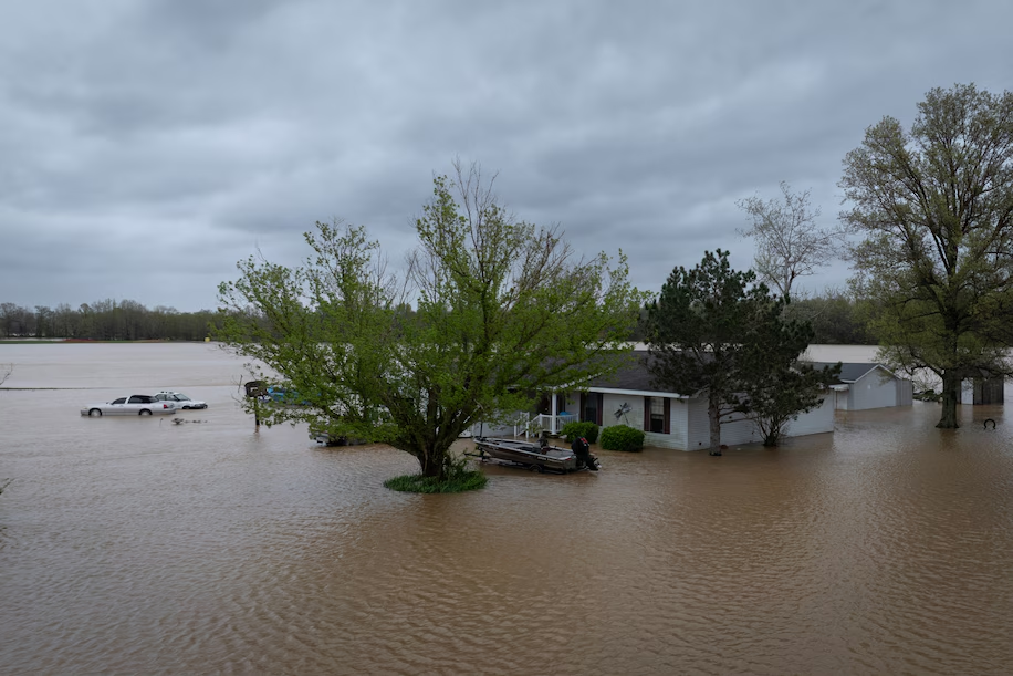 Floodwaters surround a rural home on Sunday near Poplar Bluff, Missouri. (Scott Olson/Getty Images) Floodwaters surround a rural home on Sunday near Poplar Bluff, Missouri. (Scott Olson/Getty Images)
By Matthew Cappucci
Major flooding is underway in parts of the central United States after three months’ worth of rainfall came down in just three days. Several major cities across the mid-South picked up a foot or more of rain. But even as the heavy rains diminished, giving way to more tranquil weather, there was a risk that water levels would continue to rise in the coming days.
Eighteen river gauges are reporting major flooding across the lower Mississippi Valley and Ohio Valley. An additional 42 are anticipated to go into major flood stage over the next few days. Flooding should finally subside on smaller rivers later this week, but levels may not wane until the weekend for many larger rivers.
As a result of the rapidly rising water, the National Weather Service issued 309 flash flood warnings for regions across the mid-South and Tennessee Valley over the past five days. Several of them were flash flood emergencies — or top-tier alerts used to connote an immediate threat to life and property.
In parts of the region, water levels are expected to crest Monday into Tuesday as tributaries empty into larger rivers.
In Osceola, Arkansas, major flooding is underway along the Mississippi River. Water levels typically average 12 to 18 feet; they’re expected to peak at 37.5 feet — above the 35 foot threshold for major flooding — and could stay that way until Saturday.
As of Monday morning, the water level was observed at 28.15 feet and rapidly rising.
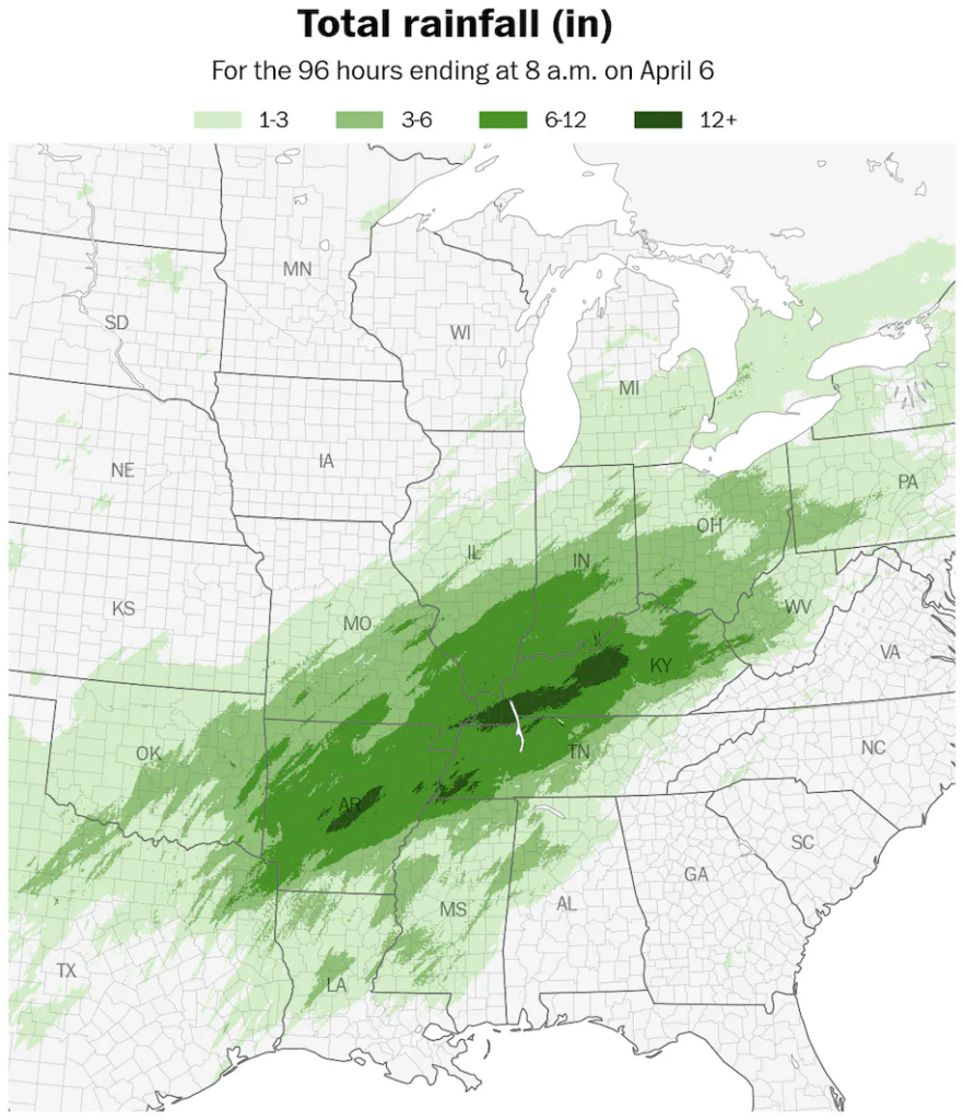 More than a foot of rain fell across parts of the Mid-South over a four day period. (Ben Noll/Data source: NOAA/MRMS) More than a foot of rain fell across parts of the Mid-South over a four day period. (Ben Noll/Data source: NOAA/MRMS)
The same is true in Hickman, Kentucky, where the Mississippi River continues to rise.
Flood stage begins at 34 feet, and major flooding at 43 feet. The river is anticipated to peak at 46.5 feet and remain there until Friday, when water levels should begin to slowly subside.
The river flooding follows days of repeated rainfall across the region.
In Arkansas, Little Rock saw 6.05 inches on Saturday alone, representing the city’s wettest April day on record. A whopping 11.84 inches fell there in four days. The April average there is 5.59 inches, meaning Little Rock got a whole month’s worth of rain in a day. In Tennessee, Memphis is up to 12.43 inches of rain for April so far; Saturday’s 5.47 inches also marked the city’s wettest April day on record.
Here’s a roundup of rain totals over the past week:
Tennessee
- Nashville: 6.32 inches.
- Clarksville: 10.13 inches.
Kentucky
- Paducah: 8:16 inches.
- Louisville: 7.52 inches.
Indiana
Missouri
- Cape Girardeau: 9.47 inches.
- Poplar Bluff: 8.57 inches.
Arkansas
- Hot Springs: 9.07 inches.
- Pine Bluff: 8.35 inches.
- Texarkana: 9.08 inches.
Louisiana
Looking ahead, high pressure over the northern Plains will shove a cold front southward, pushing cooler, dryer air over the mid-South.
That will stave off rain chances until at least Wednesday or Thursday.
By then, a smaller-scale, somewhat weak pocket of low pressure will shift to the north over the Corn Belt and Midwest.
That may introduce some downpours our thunderstorms to the Mississippi Valley by Thursday, but the chance of widespread heavy rains or severe thunderstorms will remain low.
Extreme weatherHAND CURATED
By Matthew Cappucci Matthew Cappucci is a meteorologist for Capital Weather Gang. He earned a B.A. in atmospheric sciences from Harvard University in 2019, and has contributed to The Washington Post since he was 18. He is an avid storm chaser and adventurer, and covers all types of weather, climate science, and astronomy. follow on X@MatthewCappucci |
|


