U.S. GoldMining Highlights Exploration Potential at the Muddy Creek Mineral System, Including Historic High Grade Rock Grab Samples up to 111.50 g/t Au, Whistler Gold-Copper Project, Alaska
newswire.ca
News provided by U.S. GoldMining Inc. Jun 16, 2025, 06:00 ET
ANCHORAGE, Alaska, June 16, 2025 /CNW/ - U.S. GoldMining Inc. (NASDAQ: USGO) ("U.S. GoldMining" or the "Company") is pleased to provide further details regarding high priority exploration targets located at the Muddy Creek area of its 100% owned Whistler Gold-Copper Project (the "Whistler Project" or the "Project") in Alaska, U.S.A. The evaluation of exploration targets on the Project is running concurrently with the previously announced initial assessment under U.S. Regulation S-K 1300 ("S-K 1300") and a preliminary economic assessment ("PEA") under Canadian National Instrument 43-101 ("NI 43-101"), which the Company continues to advance.
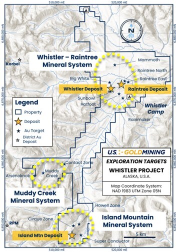
Figure 1 The Whistler Project, containing three gold ± copper ± silver mineral systems: Whistler - Raintree, which contains the existing Whistler and Raintree deposits, Island Mountain which contains the namesake gold deposit and several additional undrilled targets, and Muddy Creek which contains potential for discovery of intrusive related gold deposits. (CNW Group/U.S. GoldMining Inc.)

Figure 2 The Muddy Creek target area, comprising a large gold surface geochemical footprint over an area of approximately 6 km x 4 km with an intrusion-related gold geochemical signature. (CNW Group/U.S. GoldMining Inc.)
Highlights:
- The Muddy Creek mineral system comprises a large gold surface geochemical footprint over an area of approximately 6 km x 4 km, with an intrusion-related gold geochemical signature. It is located approximately 10 miles southwest of the Whistler deposit and 5 miles northwest of the Island Mountain deposit.
- Historic exploration work completed by previous explorers included reconnaissance rock grab sampling and soil sampling, magnetic geophysical surveying and a small drilling program which tested the margins of the system and confirmed broad low grade gold mineralization.
- Reconnaissance historic rock chip sampling has returned 73 samples which assayed >1 gram per tonne gold ("g/t Au"), including 20 samples which assayed >10 g/t Au, and peak values of 111.50 g/t Au in the 'Upper Phoenix Creek' zone, 69.13 g/t Au in the 'Bonanza' zone and 56.6 g/t Au in the central 'Muddy Creek' zone. The average gold value of 285 historic rock samples collected over the Muddy Creek area is 3.03 g/t Au, attesting to the strong gold endowment of this large system.
- Broadly spaced reconnaissance soil sampling traverses returned 104 samples which assayed >0.10 g/t Au (approximately 10 x background gold values), 56 samples returned >0.50 g/t Au and 14 samples >2.0 g/t Au. Peak gold-in soil values in the central 'Muddy Creek' zone include 5.29 g/t Au, and at 'Discovery Creek' zone up to 2.43 g/t Au.
- Historic drilling targeted the fringes of the mineral system, returning encouraging results and confirming an intrusion related gold system exists at Muddy Creek. However, the highest tenor parts of the system have not been drilled to date.
Tim Smith, Chief Executive Officer of U.S. GoldMining, commented: "In parallel with the Company's recently commenced PEA focused on the existing Whistler Project mineral resources, our technical team has continued to evolve its geological knowledge across the broader Project, and we're excited to have identified significant exploration potential across three large mineral systems identified to date. The numerous historic high grade rock and soil samples collected to date on the Muddy Creek target warrant further systematic exploration, including drilling. The Company is currently planning to develop phased exploration programs to test the highest ranking targets, including at Muddy Creek, which could potentially commence this summer field season. We're excited about this further development in the potential growth of the emerging 'West Susitna Mineral District', located just 100 miles west of Anchorage, Alaska, and the potential to discover additional gold ± copper ± silver mineralization across the 100% owned Whistler Project."
Muddy Creek Mineral System Exploration Targets
The Company's geological analysis of the Whistler Project over the first two highly successful 2023 and 2024 field seasons focused primarily on the Whistler deposit and to a lesser extent on the Whistler Orbit target area. Geologists briefly visited the Muddy Creek target area (see Figure 1), located 10 miles southwest of the Whistler deposit, during the 2024 field season to confirm mineralization style and tenor at two locations: the 'Arsenoknob' showing and the 'Contact Zone'.
Muddy Creek is hosted within a monzonitic intrusive complex, part of the Estelle Suite of intrusions that were emplaced in the late Cretaceous (~65 million years ago). Gold mineralization is of the "Intrusion-Related Gold" class of gold deposits and occurs within narrow sheeted quartz veins that contain minor arsenopyrite, pyrrhotite, pyrite and trace chalcopyrite. Exploration for intrusion related gold deposits generally is focused on areas where the vein/fracture density is highest. Surface sampling to date, comprising rock grab sampling and broad-spaced contour-parallel and ridge-line soil sampling, confirms that the best grades in the monzonite are associated with the highest observed density of veins along the strike extent of a northwest-striking structural corridor, the Discovery Creek to Bonanza zone (see Figure 2).
The average gold value of 285 rocks collected over the Muddy Creek area is 3.03 g/t Au, with a maximum value of 111.50 g/t Au, attesting to the strong gold endowment of this large system. Many of the rock samples collected are of narrow mineralized structures that occur throughout the prospect area, and while they are not representative of the potential bulk grade of the mineral system, their widespread distribution and high tenor broadly confirms a large area of potential bedrock mineralization.
Two principal trends have emerged so far from the surface geochemical data collection, each requiring further detailed mapping and sampling and remaining open along strike (see Figure 2). The Discovery Creek to Bonanza Zone, which trends NW-SE over at least 5 km of strike length, is mapped in monzogranite within the Mt Estelle pluton, with gold associated with sheeted quartz veins typical of a classic intrusion related gold system. The Contact Zone can be traced over at least 4 km, interpreted as a hornfelsed carapace to the Mt Estelle Intrusion. Detailed geological mapping and additional surface geochemical sampling is required to define the geometry of the intrusive phases and, in particular, to identify the upper zones (or 'carapace') of the host pluton, which is a typical position for the highest vein density and highest grading mineralization in intrusion related mineral systems.
In 2011, Kiska Metals Corporation conducted 955 metres of exploration drilling at Muddy Creek, the only holes drilled on this portion of the Project, located on the edges of the Discovery Creek to Bonanza higher-density vein/fracture zone. Two diamond core holes drilled near the Arsenoknob showing returned broad intercepts of low grade mineralization indicative of an intrusion related system, including:
- 0.43 g/t Au over 38.8 m from 262 m depth in hole MC11-001, and
- 0.41 g/t Au over 45.0 m from 159 m depth and 0.44 g/t Au over 44.2 m from 297 m depth in hole MC11-002.
The historic drill intercepts provide encouragement that higher grade mineralization could be discovered elsewhere within the broader Muddy Creek mineral system if zones of higher density veining can be identified. Drill hole MC11-003 near the 'Bonanza Zone' was abandoned prior to reaching target depth.
The highest tenor parts of the Muddy Creek system have not been drilled to date, including the Upper Phoenix Creek zone with rock samples up to 111.50 g/t Au, the 'Bonanza' zone with rock samples up to 69.13 g/t Au, and the central portion of the Muddy Creek zone north of Arsenoknob which contains rocks samples to 56.6 g/t Au and soil samples peaking at 3.65 g/t Au.
The Company is planning to undertake future systematic follow-up exploration at Muddy Creek. Start dates for exploration have not been determined yet.
Data Verification
For further information regarding the Project and the mineral resource estimates referenced herein, refer to the technical report summary titled "S-K 1300 Technical Report Summary Initial Assessment for the Whistler Project, South Central Alaska" with an effective date of September 12, 2024, and the technical report titled "NI 43-101 2024 Updated Mineral Resource Estimate for the Whistler Project, South Central Alaska" with an effective date of September 12, 2024, available under the Company's respective profiles at www.sec.gov and www.sedarplus.ca.
Rock samples referenced herein consisted of approximately one kilogram of rock collected over a small area surrounding each sampling site collected with a rock hammer. The sampling location was located using a handheld GPS unit and marked in the field with a metallic tag. Descriptive information about the geology of the sample was recorded and aggregated into the project database. Soil samples were collected along traverses as part of multi-kilometre reconnaissance programs, generally at 100 meter spacing. Soil samples were collected from the surface soils (generally the B-horizon) by extracting approximately one kilogram of soil, usually with a hand auger. Each sampling site is located using a GPS unit. Descriptive information such as sample depth and physical attributes were recorded and aggregated into the project database. Typically, field duplicates were collected at a rate of one in every twenty samples.
Historic rock and soil samples were predominantly submitted to Alaska Assay Laboratories for preparation. Pulps were then submitted to ALS-Chemex by the preparation laboratory for assaying. Gold was assayed by fire assay and atomic absorption finish (Au-AA23) on thirty gram sub-samples and for a suite of 33 elements (including copper and silver) by either aqua regia digestion or 3- or 4-acid digest, followed by ICP-AES (method code ME-ICP41) on 0.5 gram sub-samples. Elements exceeding concentration limits of ICP-AES were re-assayed by single element aqua regia digestion and atomic absorption spectrometry (method code element-AA46). The Company's 2024 sampling utilized Bureau Veritas for sample preparation at their lab in Fairbanks, Alaska, and analysis at their laboratory in Vancouver, BC. The analysis utilized FA430 fire assay method using 30 grams of material for gold, and MA200 multi-acid digestion with an ICP-ES/MS analysis on 0.25 gram sample for base metals.
Technical Information
Tim Smith, P.Geo., Chief Executive Officer of U.S. GoldMining, has supervised the preparation of this news release and has reviewed and approved the scientific and technical information contained herein. Mr. Smith is a "qualified person" as defined in Canadian National Instrument 43-101 – Standards of Disclosure for Mineral Projects.
About U.S. GoldMining Inc.
U.S. GoldMining Inc. is an exploration and development company focused on advancing the 100% owned Whistler Gold-Copper Project, located 105 miles (170 kilometers) northwest of Anchorage, Alaska, U.S.A. The Whistler Project consists of several gold-copper porphyry deposits and exploration targets within a large regional land package entirely on State of Alaska mining claims totaling approximately 53,700 acres (217.5 square kilometers). The Whistler Project Mineral Resource Estimate comprises 294 Mt at 0.68 g/t AuEq for 6.48 Moz AuEq Indicated, plus 198 Mt at 0.65 g/t AuEq for 4.16 Moz AuEq Inferred.
Visit www.usgoldmining.us for more information, including high resolution figures.
Forward-Looking Statements
Except for the statements of historical fact contained herein, the information presented in this news release constitutes "forward-looking statements" within the meaning of the United States federal securities laws and "forward-looking information" within the meaning of applicable Canadian securities laws (collectively, "forward-looking statements"). Such statements include statements with regard to the Company's expectations regarding the Project, potential exploration targets, future work programs and the Project's exploration potential. Words such as "expects", "anticipates", "plans", estimates" and "intends" or similar expressions are intended to identify forward-looking statements. Forward-looking statements are based on U.S. GoldMining's current expectations and are subject to inherent uncertainties, risks and assumptions that are difficult to predict and involve known and unknown risks, uncertainties and other factors, which may cause the actual results, performance or achievements of the Company to be materially different from any future results, performance or achievements expressed or implied by such forward-looking statements. Such risks and other factors include, among others, the actual results of future exploration may not confirm expectations, variations in the underlying assumptions associated with the estimation or realization of mineral resources, the availability of capital to fund programs, accidents, labor disputes and other risks of the mining industry including, without limitation, those associated with the environment, delays in obtaining governmental approvals or permits, title disputes other risks inherent in the exploration and development of mineral properties and the other risk factors set forth in the Company's filings with the U.S. Securities and Exchange Commission at. www.sec.gov and Canadian Securities Administrators at www.sedarplus.ca. Although the Company has attempted to identify important factors that could cause actual actions, events or results to differ materially from those described in forward-looking statements, there may be other factors that cause actions, events or results not to be as anticipated, estimated or intended. Accordingly, readers should not place undue reliance on forward-looking statements contained in this news release. Forward-looking statements contained in this news release are made as of this date, and U.S. GoldMining does not undertake any duty to update such information except as required under applicable law.
SOURCE U.S. GoldMining Inc.
 For additional information, please contact: U.S. GoldMining Inc., Alastair Still, Chair; Tim Smith, Chief Executive Officer; Telephone Toll Free: 1-833-388-9788, Email: info@usgoldmining.us For additional information, please contact: U.S. GoldMining Inc., Alastair Still, Chair; Tim Smith, Chief Executive Officer; Telephone Toll Free: 1-833-388-9788, Email: info@usgoldmining.us
|


