Battle Mountain Gold (BMG-V) June 21, '16 is pleased to announce recent exploration activities and plans for future work in the Lewis gold-silver property, which lies near the town of Battle Mountain in Nevada.
Highlights:
Plans to commence a twelve-hole, diamond-core drill program (4500 m) over the Virgin, Buena Vista and Meagher target zones in August.
Recently completed helicopter-borne magnetic and radiometric survey and ground-based gravity survey over the Lewis claim group and surrounding areas. Data and image processing is underway with interpretive results to be released around the end of June.
Three geologists and one geological data manager employed out of Reno and Elko, Nevada.
Geological mapping (1:2,000-scale) and geochemical rock-sampling underway in the northeastern part of the project area.
Completion of re-logging of drill-core collected from the Virgin zone by Madison Minerals Inc. during 2003 - 2008. Plans to continue re-logging of Madison reverse-circulation drill-chips with the aim of better understanding the 3D controls to gold-silver mineralization.
project area to better delineate the surface expression of gold-silver-bearing fault zones and potential drill targets at depth.
Further Information:
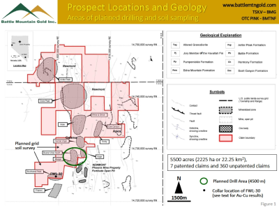
The Company has hired three contract geologists to progress mapping and drilling activities. A ground-based gravity survey and helicopter-borne magnetic / radiometric survey were completed over the claim area in late May - early June. The data from these surveys are now being processed and integrated with 3D geology; results are expected to be released by the end of June. The Company has resumed re-logging of drill-core previously collected by Madison Minerals Inc. from 2003 to 2008 in the Virgin zone and geological surface mapping in northeastern part of project area (Figure 1). Plans are for the multi-element, geochemical soil-grid sampling of the southwestern portion of the claim area to further delineate the surface expression of gold-bearing fault zones. Surface mapping and geochemical sampling, three-dimensional geological modeling and re-processing of previously collected TITAN - MT data have established potentially high-grade gold-silver targets, set out in accompanying Figures 1 to 3. The Company plans to commence testing of these targets by diamond drilling this August.
At least eight mineralized zones were previously recognized in the Lewis property (Figure 1). The best understood gold-silver systems to date include the Virgin, Buena Vista, Meagher, White-Shiloh and Trinity structural zones, which are open along strike and at depth. Gold- and silver-bearing portions of these zones exceed 1,200 m for the Virgin; 1,300 m for Buena Vista; 650 m for Meagher; 900 m for White-Shiloh; and 1,700 m for Trinity 1. Recent geochemical sampling of these zones and new areas of mineralization indicate rock-chip results of up to 99.9 g/t Au, 5600 g/t Ag, 11.8% Pb and 6.2% Zn. The locations, descriptions and assay results for the rock-chip data are included in previous press-releases and a spread-sheet on the Company's web-site under Investor Info/Presentations/Lewis Property Rock-chip Database.
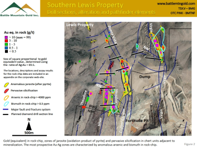
Recent work in the southern part of the Lewis property indicates three major zones of interest, including the Virgin, Buena Vista and Meagher zones (Figure 2). Each of these areas is characterized by significantly anomalous gold, silver, arsenic and bismuth in rock-chip samples. The Virgin fault system returns up to 53.4 g/t Au and 203 g/t Ag from surface rock-chip sampling. Drill-hole results from diamond- and RC-drilling completed by Madison (2003 to 2008)1 indicates highlights of 21m @ 6.9 g/t Au and 64 g/t Ag from 76 m (MAD-83); 85 m at 2.2 g/t Au and 27 g/t Ag from 64 m (MAD-18), including 15.2 m at 9.0 g/t Au and 37 g/t Ag from 119 m; and 46 m at 6.5 g/t Au from 61.0 m (MAD-31), including 6.1 m at 21.5 g/t Au from 73.2 m1.
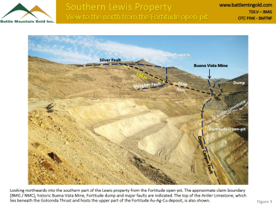
Silver values in rock-chip up to 5600 g/t Ag and gold results up to 13.2 g/t Au characterize the Meagher zone in the western part of the property. This zone consists of two north-trending and west-dipping faults, the Meagher and Silver Faults, each more than 650 m long. These mineralized structures and those of the Buena Vista system, with surface values of up to 24.7 g/t Au and 359 g/t Ag, extend to the south into the Fortitude copper-gold-silver mine, which is operated by Newmont Mining (Figure 3). The intersection of these mineralized structures with the reactive rocks that lie beneath the Golconda Thrust and host ore in the Fortitude deposit will be the focus of future diamond drilling by the Company. Results from RC-drilling completed by Madison at Buena Vista indicates 7.6 m at 5.44 g/t Au and 69 g/t Ag from 12.2 m, including 3.0 m at 12.7 g/t Au and 691 g/t Ag from 12.2 m (MAD-64) 1. However, this drill-hole and others in the area did not adequately test the reactive rock units that lie beneath the Golconda Thrust.
A total of 14 diamond-core holes and 48 reverse-circulation (RC) holes completed previously by Madison were re-logged in late-2014 to mid-2015 with an aim to better define lithology, hydrothermal alteration, sulfide mineralization and structure in drill-hole. The integration of the results of the re-logging program with the district-wide drill database and the results of surface mapping has led to the creation of three-dimensional geological and structural models for the claim area. An additional 9 diamond-core holes were re-logged in late May to early June of this year, to bring the project total to 23 core-holes, which will allow for a better understanding of the 3D controls to gold-silver mineralization in the Virgin zone. Re-logging of reverse-circulation holes has recommenced, with plans to bring the project total to about 80 RC-holes prior to the start of the diamond drill program in August.
A ground-based gravity survey was completed over the Lewis project area (22.25 km2) in late May by Magee Geophysical Services for a total of 289 stations. Preliminary processing of the results indicates the major gold-silver-bearing fault zones that juxtapose rock units of contrasting density (specific gravity) locally coincide with gravity gradients or zones of rapidly changing gravity expression. This relationship will assist the Company in targeting large and potentially well-mineralized fault zones for future exploration and drilling.
A helicopter-borne magnetic and radiometric survey was flown over the project environs by Precision Geosurveys during early June. The survey covered about 110 km2 for a total of 1270 line-km, consisting of east-west oriented flight-lines spaced 100 m apart and north-south tie-lines spaced every 1000 m. The survey height was a nearly constant height of 25 m above the ground. Preliminary images of the magnetic results show a spatial coincidence between gold-silver bearing fault zones and intrusions with magnetic gradients and disruptions in magnetic trends. A separate news release will be made following the final processing and imaging of the gravity, magnetics and radiometric data and integration with the 3D geometry of mineralized fault zones and prospective host-rock units.
Plans are for the grid-soil sampling of portions of the southwestern part of the claim area (Figure 1) along east-west oriented lines spaced 60 m (200 feet) apart with samples spaced every 30 m (100 feet). Every two field samples will be composited to one multi-element assay sample to create uniform coverage over a 60 m by 60 m (200 feet by 200 feet) grid. The purpose of the survey is to further delineate the surface expression of gold-bearing fault zones using a multi-element geochemical approach. For example, previous drilling by Barrick Gold (1987) in this area indicates 16.7 m at 5.86 g/t Au and 0.2% Cu from 775.7 m in FWL-30 1, hosted by skarn in the Antler Limestone that lies beneath the Golconda Thrust (Figure 1). Previous work by the Company indicates that gold-silver-bearing target zones, contained within reactive host rocks beneath the Golconda Thrust, are typically expressed by multi-element anomalies in the Havallah / Pumpernickle Formation at surface. These surface anomalies are characterized by elevated arsenic, bismuth, low-level gold and silver, and other pathfinder elements. The grid soil-survey will cover portions of the 4 km2 area of interest and commence within the next month.
The most compelling exploration targets delineated to date lie in the Virgin, Buena Vista and Meagher-Silver areas. It is planned to test these targets by a twelve hole, 4500 m diamond drill-program scheduled to start in August. The locations of the planned drill-sections are illustrated in Figure 2. Attractive targets also exist in the Galena, White-Shiloh and Trinity systems, which are intended for drill-testing in 2017. Any additional targets generated by the recently completed geophysical programs and future soil-grid work will be advanced to the drill-stage through surface mapping and geochemical sampling.
The Lewis property consists of a 2,225 hectare (5,500 acre) land position directly north of Newmont's Fortitude open-pit mine. Metals production in 2015 from the Fortitude-Phoenix operation includes 205,000 ounces of gold, 46 million pounds of copper and by-product silver, and at December 31, 2015 reported reserves of 5.1 million ounces of gold and 1,750 million pounds of copper (Page 30, Newmont 2015 Annual Report) 2. The Lewis property consists of seven patented and 360 unpatented mining claims. Historic mining of gold, silver and base metals occurred along several northerly-trending lodes in the claim group.
The Company commenced exploration of the Lewis property in late June, 2014. The field-work completed to date consists of detailed geological surface mapping (1:2,000-scale), geochemical rock- and soil-sampling, and re-logging of diamond-core and RC-chips from drill-holes completed by Madison Minerals Inc. from 2003 to 2008. The emphasis during this work has been on the geometric controls to gold-silver-and base metal-bearing fault and fracture systems. These target structures cut across several rock formations that have properties conducive to metals deposition, including the same formations that host ore in the Fortitude mine of Newmont, located directly to the south. These target settings will be the focus for diamond drilling in the Virgin, Buena Vista and Meagher areas (Figure 2).
Chet Idziszek, President of Battle Mountain Gold Inc., comments:
"The 3D modelling work completed by Dr. Steve Garwin and his Nevada-based geological team has generated high grade gold-silver targets on the Lewis property of Battle Mountain Gold, which is contiguous with the Fortitude-Phoenix mine operations of Newmont. These targets are the focus of the drill program scheduled to start in the 3rd Quarter of this year. The preliminary results of the recently completed helicopter-borne magnetic / radiometric survey and ground-based gravity survey suggest that mineralized fault zones are well-expressed by geophysics, which will improve the chances of discovery."
Qualified Person
Steve Garwin PhD, FAIG, FAusIMM, FSEG and Director of Battle Mountain Gold Inc. is a qualified person, as defined by NI 43-101. He is responsible for the preparation of the technical information in this press-release.
Grants of incentive stock options
The Company advises that it has made grants of incentive stock options to its directors and senior officers in respect of 1,225,000 shares, exercisable at the price of $0.60 per share for a five-year period ending June 18, 2021.
To find out more about Battle Mountain Gold Inc. please visit our website at www.battlemtngold.com .
On behalf of the Board of Directors of
BATTLE MOUNTAIN GOLD INC.
"Chet Idziszek"
Chet Idziszek, President
Click Image To View Full Size
Click Image To View Full Size
Click Image To View Full Size
1 Descriptions of the mineralized zones and tables of drill-hole assay results can be found in a 43-101 report dated March 2014 titled AMENDED AND RESTATED SUMMARY REPORT 2007-2008 CORE AND REVERSE CIRCULATION DRILLING PROGRAM, F.W. LEWIS PROPERTY, BATTLE MOUNTAIN MINING DISTRICT, LANDER COUNTY, NEVADA, USA, (the "2014 43-101 Report") filed on SEDAR under the Company's profile and also on the Company's website under Investor Info/Articles, Agreements and Reports.
2 This information about Newmont's Fortitude mine is drawn from Newmont's publicly disclosed sources cited. Newmont's Fortitude mine is discussed in Section 15.1 of Battle Mountain's 2014 43-101 Report, which includes the statement, "The geologic information from the adjacent Phoenix [Fortitude] Mine deposits and the comparison with the adjoining Lewis property is in no way indicative that a mineral deposit of similar size or grade does occur or will be found on the Lewis property". |


