New Pacific Metals (NUAG-T) Commences a 38,000 Metre Exploration and Resource Expansion Drill Program at its Flagship Silver Sand Project
July 27, '21 - NR
New Pacific Metals is pleased to announce it has commenced a 38,000 metre ("m") diamond drill program at its flagship Silver Sand Project ("Silver Sand" or the "Project"), Potosí Department, Bolivia.
HIGHLIGHTS:
38,000 m drill program in progress;
~80% of the drill program is focused on expanding the existing Mineral Resources and on discovering additional resources; the deposit is open along strike and at depth;
5,000 m of the drill program dedicated to testing for feeder zones for the large Silver Sand deposit;
District exploration drilling to target the North Block and Snake Hole Zone;
Mineral continuity and geotechnical drilling to support the Silver Sand Preliminary Economic Assessment ("PEA"); and
Environmental baseline, socioeconomic and social responsibility studies underway. SILVER SAND 2021 DRILL PROGRAM
Two diamond drill rigs are currently active on the Project and two additional drill rigs are scheduled to arrive at the Project over the coming days. It is expected that four drill rigs will be fully operational in August 2021.
The objectives of the 38,000 m drill program are to expand the existing Silver Sand resource, which remains open along strike and at depth, and to complete geotechnical drilling to support the PEA study. The drill program is comprised of three main components:
Resource expansion: ~23,500 m planned for expansion of the existing Mineral Resource and to complete initial dill testing for potential feeder zones;
Exploration: ~6,500 m planned for exploration at the newly discovered Snake Hole Zone and the North Block properties; and
Mineral continuity and geotechnical drilling: ~8,000 m planned to support ongoing PEA studies. In addition to the 2021 drill program, the Company continues to advance and has initiated key studies and initiatives in support of the Silver Sand Project development. These include environmental baseline, socioeconomic and hydrogeology studies.
Details of the drill program follow in the sections below.
RESOURCE EXPANSION
Drilling to date indicates the Silver Sand hydrothermal system remains open for expansion along strike and at depth. The Company has allocated ~23,500 m of the drill program to potentially grow the existing Mineral Resources by testing gaps in the current model and by drilling exploration targets adjacent to and beneath the current conceptual constrained Mineral Resource under National Instrument 43-101 — Standards of Disclosure for Mineral Projects ("NI 43-101"). The primary focus will be on drilling the area between the Central and South Zones, in the Mirador Area, with the remainder testing the northern strike extent of the deposit (Figure 1).
Feeder Zones
To date, approximately 100,000 m have been drilled at the Project in about 400 diamond drill holes that have tested only the upper ~250 m to 300 m of the large, silver-rich, hydrothermal system. None of the drill holes have encountered mineralized intrusive source rocks and/or thicker, higher grade, structurally controlled fluid conduits, which are postulated to be the source of the silver mineralization.
Analysis of the data suggests an intrusive heat source and associated structural plumbing system for the deposit may occur at depth between the Central and South Zones, in the Mirador Area (Figure 1). Circumstantial evidence for this hypothesis includes: the increased structural complexity of the area; the presence of thicker mineralized veins which were the sites of the majority of historic mining activities; an increase in anomalous base metal content, especially zinc, within the lower portions of drill holes completed in the immediate area; a localized increase in alteration assemblage minerals suggestive of higher heat flow (i.e., muscovite-sericite); and the presence of a post-mineral volcanic diatreme breccia nearby. Of the 23,500 m allocated to resource expansion, ~5,000 m are designed to explore the system at depth, with several 1,000 metre-long drill holes planned (Figure 1).
EXPLORATION
Snake Hole Zone
Located approximately 600 m east of the currently defined Silver Sand deposit (Figure 2), the Snake Hole Zone was drilled in late 2019 with highlighted results of 279 g/t silver over 72.44 m, including 517 g/t silver over 32.96 m in discovery hole DSS5218. Please refer to the Company's news release dated January 13, 2020 for further details.
During the first quarter of 2020, an additional eight follow-up drill holes were completed. Multiple drill holes intersected several zones of structurally controlled silver mineralization with highlighted results of 126 g/t silver over 39.39 m, including 159 g/t silver over 30.93 m and 354 g/t silver over 12.26 m in hole DSS5228. Please refer to the Company's news release dated August 6, 2020 for further details.
The objective of the 2021 drill program is to better understand the size potential of these silver zones and to continue the exploration of the target along the 650 m strike extent to the north. A total of 2,500 m have been allocated for this phase of work.
North Block
At the beginning of the fourth quarter of 2021, the Company plans to commence the inaugural drilling of the North Block properties, which include the El Bronce, Jisas and Jardan areas. Approximately 4,000 m in 18 drill holes are planned for the initial test.
At the district scale, the North Block occurs within the Eastern Intrusive Trend (Figure 2). The geology of the North Block differs considerably from that at Silver Sand as it is comprised of intermediate to felsic intrusive units, which are a more geologically typical sequence for the deposit type being explored for. Notably, the El Bronce property contains numerous historic mine workings that exploited both steeply dipping and flat-lying, high-grade, silver-rich polymetallic veins over an area approximately 500 m wide by 1 km long in strike. Detailed geological mapping indicates the intrusive host rocks are pervasively flooded by moderate to intense alteration, which reflects the passage of silver-rich hydrothermal fluids (phylic alteration (sericite) with local argillic (kaolinite) and propylitic (chlorite-epidote) zones). Surface mapping has also identified good to moderate micro-veining and stockwork development between the principal historically exploited structures thereby forming an attractive bulk tonnage target.
Importantly, the geology, alteration and style of existing silver mineralization at the North Block provides compelling evidence that the Silver Sand deposit forms part of a larger regional to district-scale, silver-rich, hydrothermal system or systems whose exploration potential remains to be unlocked.
MINERAL CONTINUITY AND GEOTECHNICAL DRILLING
To support the current PEA and future advanced engineering and mining studies, the Company will complete approximately 8,000 m of short-interval, orientated, mineral continuity and geotechnical, cross-style drill-sets, in three separate areas in the south and north portions of the Central Zone and within the West Zone (Figure 2). Drill spacing for these holes will vary from 5 m to 10 m on section and along strike. The data will be used to provide intra-hole continuity information at the current drill spacing of under 25 m and detailed geotechnical and vein orientation data for future studies, which are expected to be conducted after the completion of the PEA.
In addition, the geotechnical drill holes are expected to support the planning of mine infrastructure and pit stability studies. The drill core derived from this phase of drilling will also be utilized for future geometallurgical test programs.
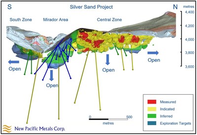
Figure 1: Long Section of the Silver Sand resource model, looking west, displaying selected drill holes for the 2021 drill program: yellow drill trace = deep drill holes exploring feeder zones; blue and green drill trace = resource expansion and exploration drill holes. Resource model as presented in the Company's Technical Report entitled "Silver Sand Deposit Mineral Resource Report (Amended)" dated June 3, 2020 (effective date of January 16, 2020) and prepared by AMC Mining Consultants (Canada) Ltd.
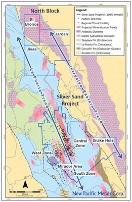
Figure 2: Surface geology map of the Silver Sand Project indicating locations of current drill target areas (the Snake Hole Zone, the North Block properties and PEA-related continuity drilling) and locations of previous diamond drilling.
QUALIFIED PERSON
The scientific and technical information contained in this news release has been reviewed and approved by Gary DeSchutter, M.Sc., P. Geo., Manager Silver Sand Project, who is a Qualified Person for the purposes of NI 43-101. The Qualified Person has verified the information disclosed herein, including the sampling, preparation, security and analytical procedures underlying such information, and is not aware of any significant risks and uncertainties that could be expected to affect the reliability or confidence in the information discussed herein.
ABOUT NEW PACIFIC
New Pacific is a Canadian exploration and development company with precious metal projects, including the flagship Silver Sand Project, the Silverstrike Project and the Carangas Project, all of which are located in Bolivia. The Company is focused on progressing the development of the Silver Sand Project, while growing its Mineral Resources through the exploration and acquisition of properties in the Americas.
For further information, please contact:
Stacey Pavlova, CFA
VP, Investor Relations and Corporate Communications
New Pacific Metals Corp.
Phone: (604) 633-1368
U.S. & Canada toll-free: 1-877-631-0593
E-mail: info@newpacificmetals.com
www.newpacificmetals.com
To receive company news by e-mail, please register using New Pacific's website at www.newpacificmetals.com. |


