Alamos Gold Provides Exploration Update for the Lynn Lake Project, Manitoba, Including a New Greenfields Discovery
ca.finance.yahoo.com
Alamos Gold Inc.
Thu., December 16, 2021, 3:50 a.m.
Figure 1: Lynn Lake Project

Figure 1: Lynn Lake Project
Figure 1: Lynn Lake ProjectFigure 2: Lynn Lake – Tulune Target Area – Drillhole Plan Map

Figure 2: Lynn Lake – Tulune Target Area – Drillhole Plan Map
Figure 2: Lynn Lake – Tulune Target Area – Drillhole Plan MapFigure 3: Lynn Lake – Gordon Deposit – Drillhole Plan and Cross Section Looking West
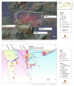
Figure 3: Lynn Lake – Gordon Deposit – Drillhole Plan and Cross Section Looking West
Figure 3: Lynn Lake – Gordon Deposit – Drillhole Plan and Cross Section Looking WestFigure 4: Lynn Lake – MacLellan Deposit – Drillhole Plan and Composite Longitudinal Looking Northwest
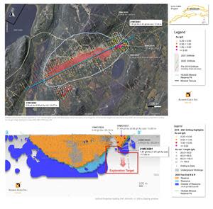
Figure 4: Lynn Lake – MacLellan Deposit – Drillhole Plan and Composite Longitudinal Looking Northwest
Figure 4: Lynn Lake – MacLellan Deposit – Drillhole Plan and Composite Longitudinal Looking NorthwestFigure 5: Lynn Lake – Burnt Timber and Linkwood – Drillhole Plan Map

Figure 5: Lynn Lake – Burnt Timber and Linkwood – Drillhole Plan Map
TORONTO, Dec. 16, 2021 (GLOBE NEWSWIRE) -- Alamos Gold Inc. (TSX:AGI; NYSE:AGI) (“Alamos” or the “Company”) today reported new results from its ongoing exploration program on the Lynn Lake Project in Manitoba, Canada.
New greenfields discovery (Tulune target): broad zones of shallow gold mineralization intersected between the Gordon and MacLellan deposits which were the basis for the positive 2017 Feasibility Study. All 17 holes drilled to date in this new target have intersected gold mineralization. New highlights include1:
1.22 g/t Au over 47.25 m (20LLX010);
0.50 g/t Au over 63.00 m, and 0.82 g/t over 29.00 m (21LLX019);
1.43 g/t Au over 16.40 m (21LLX017);
0.52 g/t Au over 41.80 m (21LLX020);
0.83 g/t Au over 17.90 m (21LLX016);
1.05 g/t Au over 12.75 m (21LLX026); and
0.53 g/t Au over 25.87 m (20LLX009), including;
20.20 g/t Au over 0.47m.
1Gold grades are reported as uncut, composite intervals reported as core length, true width is unknown at this time.
Gordon deposit: high-grade mineralization intersected in the southeast portion of the Mineral Reserve pit in an area currently modelled as waste. This includes high-grade gold mineralization intersected in a series of narrow quartz veins within a diorite intrusion. High-grade near-surface gold mineralization was also intersected along the diorite-banded iron formation contact at the eastern extent of the Mineral Reserve pit (21GDX074). New highlights include2:
28.36 g/t Au (7.77 g/t cut) over 10.40 m (21GDX054), including;
302.00 g/t Au (40 g/t cut) over 0.24 m;
372.00 g/t Au (40 g/t cut) over 0.21 m;
176.00 g/t Au (40 g/t cut) over 0.24 m;
96.20 g/t Au (40 g/t cut) over 0.70 m; and
73.30 g/t Au (40 g/t cut) over 0.23 m;
67.64 g/t Au (4.38 g/t cut) over 5.04 m (21GDX052), including;
1,105.00 g/t Au (40 g/t cut) over 0.30 m;
7.42 g/t Au (4.73 g/t cut) over 7.20 m (21GDX074), including;
35.07 g/t Au (17.34 g/t cut) over 1.07 m; and
1.49 g/t Au (1.49 g/t cut) over 20.53 m (21GDX042).
MacLellan deposit: extended gold mineralization 45 m down-plunge from existing Mineral Reserves in the northeastern portion of the Mineral Reserve pit. This follows multiple higher-grade intercepts from the 2019 and 2020 drill program within a steeply plunging ore shoot that remains open down-plunge (11.49 g/t Au (8.98 g/t cut) over 14.93 m true width (19MCX037), 3.24 g/t Au (3.24 g/t cut) over 23.13 m true width (19MCX028), and 2.84 g/t Au (2.84 g/t cut) over 20.02 m true width (20MCX044)). New highlights include2:
1.81 g/t Au over 17.44 m (21MCX081).
Burnt Timber deposit: infill drilling in support of developing a geological model highlights the potential for higher-grade Mineral Resources at the Burnt Timber deposit. Burnt Timber was not included in the 2017 Feasibility Study and represents potential upside. New highlights include2:
2.51 g/t Au over 16.45 m and 1.63 g/t Au over 15.54 m (21BTX045);
3.11 g/t Au over 9.36 m (21BTX044); and
1.06 g/t Au over 15.99 m (21BTX047).
2Drillhole composite intervals reported as “cut” include higher grade samples which have been cut to 40 g/t Au at the Gordon and Burnt Timber deposits and 45 g/t Au at the MacLellan deposit. All composite lengths are reported as true width.
“Since completing the Feasibility Study on the Gordon and MacLellan deposits in 2017, Mineral Reserves have increased 27% to 2.1 million ounces of gold. Our ongoing exploration success demonstrates the potential for further Mineral Reserve and Resource growth at both deposits as well as regionally across the prospective and underexplored Lynn Lake greenstone belt. This includes the discovery at Tulune, a new target located between Gordon and MacLellan, where every hole drilled to date has intersected gold mineralization. Tulune, a strong pipeline of other regional targets, and the large Mineral Resource at Burnt Timber and Linkwood, all highlight the significant potential within the district and upside beyond what was outlined in the Feasibility Study” said John A. McCluskey, President and Chief Executive Officer.
New highlight intercepts can be found in Table 1, and in Figures 1 to 5 at the end of this news release.
Lynn Lake Project
The Lynn Lake Project (“LLGP”) encompasses most of the east-trending, 125 kilometre (“km”) long, Paleoproterozoic Lynn Lake Greenstone Belt (“LLGB”) in northwestern Manitoba (Figure 1) with a total of 58,000 hectares of mineral tenure.
A positive Feasibility Study on the LLGP was completed in December 2017 based on Mineral Reserves within the MacLellan and Gordon deposits. The Feasibility Study outlined average annual production of 143,000 ounces over a 10-year mine life at average mine-site all-in sustaining costs of $745 per ounce. The project economics (based on the 2017 Feasibility Study) at a $1,500 per ounce gold price include an after-tax IRR of 21.5% and an after-tax NPV of $290 million (12.5% IRR at a $1,250 per ounce gold price). During the second quarter of 2020, the Company filed the Environmental Impact Statement ("EIS") with the federal government. The federal and provincial permitting process is expected to take approximately two years, with a construction decision planned in the second half of 2022.
Following the completion of the Feasibility Study in 2017, ongoing exploration success has driven a 435,000 ounce increase in Mineral Reserves to 2.1 million ounces of gold (36.5 million tonnes (“mt”) grading 1.75 g/t Au) and a 116,000 ounce increase in Measured and Indicated Mineral Resources at Gordon and MacLellan to 360,000 ounces of gold (6.1 mt grading 1.85 g/t Au). Additionally, the Burnt Timber and Linkwood deposits contain Inferred Mineral Resources of 1.6 million ounces of gold (44.4 mt grading 1.10 g/t Au) which were not included in the Feasibility Study and remain a source of further potential upside.
The 2021 exploration program was focused on the Gordon, MacLellan, and Burnt Timber deposits, which are all past producing mine sites, as well as several advanced stage greenfield targets. Drilling successfully intersected significant gold mineralization at all three brownfield sites and at two of the regional targets, Tulune and McBride (Figure 1).
A total of 17,020 metres (“m”) of drilling was completed at the LLGP in 2021 with total exploration expenditures of $8.1 million as of November 30, 2021.
Tulune Target Area – New Discovery
The Tulune target area is located in the northern portion of the Lynn Lake greenstone belt, 23 km east of the MacLellan Deposit, and 11 km west of the Gordon Deposit (Figure 1), at a flexure in the regional crustal-scale Agassiz Shear Zone that is interpreted to extend the length of the north belt. Drilling completed in 2020 and 2021 intersected gold mineralization in two elongated granodiorite intrusions.
Gold mineralization was initially identified in the Tulune area during a prospecting program conducted in 2015. The prospecting program resulted in the discovery of frost-heaved altered granodiorite boulders which returned gold values up to 361 g/t Au (associated with visible gold in a quartz vein).
Alamos completed additional prospecting, mapping, soil sampling, and reprocessing of historic induced polarization (IP) survey data in the area which resulted in 978 m of drilling completed in five holes in 2020 (Figure 2). Initial drilling tested two east-southeast striking granodiorite intrusions and adjacent mafic and sheared ultramafic volcanic rocks. The most significant result was from drillhole 20LLX010 that intersected 1.22 g/t Au over 47.25 m from the top of the hole in the northern granodiorite. Gold mineralization was also intersected in the southern granodiorite in drillhole 20LLX006 (0.50 g/t Au over 9.8 m).
A follow-up drill campaign was completed in 2021, comprised of 12 holes totaling 4,986 m following up on drillhole 20LLX010. The program was heli-supported with drill holes designed to step back and undercut the shallow mineralization intersected in drillhole 20LLX010. Two step-out drill fences were also completed approximately 200 m west and 500 m east of drillhole 20LLX010, and in the central portion of the northern granodiorite to test the strike extension along the southern contact, as well as a stratigraphic hole to test the northern contact (Figure 2).
All 17 holes drilled to date have intersected gold mineralization. Anomalous gold values are most widespread in the northern granodiorite which was the primary target of the 2021 drilling, though gold mineralization has been intersected in both intrusions. Gold mineralization is hosted within intervals of fracture-controlled pyrite. Pyrite occurs within the semi-pervasive healed biotite-silica-chlorite-carbonate-sericite stockwork and is also observed interstitially within the matrix. Although the controls of gold mineralization are still under investigation, gold grades appear proportional to pyrite-bearing fracture densities that are spatially associated with hematite alteration, mylonitic shears, cataclasites, breccias, and with late mafic dykes in the granodiorite.
Significant intersections from the 2020 and 2021 drilling programs in the Tulune target area include (Figure 2):
1.22 g/t Au over 47.25 m (20LLX010);
0.50 g/t Au over 63.00 m, and 0.82 g/t over 29.00 m (21LLX019);
1.43 g/t Au over 16.40 m (21LLX017);
0.52 g/t Au over 41.80 m (21LLX020);
0.83 g/t Au over 17.90 m (21LLX016);
1.05 g/t Au over 12.75 m (21LLX026);
0.53 g/t Au over 25.87 m (20LLX009), including;
20.20 g/t Au over 0.47m;
0.56 g/t Au over 31.58 m (21LLX024); and
0.50 g/t Au over 27.65 m (21LLX021).
Drilling at Tulune in 2022 will focus on targeting various structural and lithological settings with the objective of defining higher-grade mineralization within this newly discovered gold system. Interpretation of the HeliFALCON airborne gravity gradiometry and magnetic data suggests that the host granodiorite intrusion is 7,500 m long by up to 1,200 m wide and occurs within a structural corridor up to 2,500 m wide. The 2020 and 2021 drill programs tested the western most 750 m of strike length. Gold values of >0.1 g/t Au from grab samples are widespread in this corridor and additional reprocessing of historic IP/resistivity survey data is in progress to support targeting.
Gordon Deposit
The Gordon gold deposit is located 37 km east-northeast of the town of Lynn Lake and accessed by an all-weather gravel road that extends 14 km north from Highway 391 (Figure 1). Gold mineralization at Gordon is predominantly hosted in banded magnetite iron formation (“BIF”) in quartz-pyrrhotite-pyrite veins and in halos of sulphide replacement adjacent to the veins. There are two dominant vein sets: one that is parallel to a subvertical east-striking foliation and a second that dips moderately southwest at a high angle to the foliation. The BIF occurs north and south of an argillite-wacke unit situated in the core of an upright west-plunging isoclinal synform. The BIF is separated from a diorite stock to the south by an interval of dacite, greywacke, and silicate iron formation up to 100 m wide. Though BIF is the primary host of gold mineralization, gold occurs in all lithologies.
The 2021 Gordon drilling program consisted of 34 holes totaling 5,545 m, with the objective of further extending gold mineralization within and in proximity to the Mineral Reserve pit (Figure 3). Drilling tested two geological targets: mineralization along the diorite contact in the southwest and eastern extents of the Mineral Reserve pit (Figure 3, cross section 21GDX074), and veins in the diorite in the southeast portion of the Mineral Reserve pit. Significant gold mineralization was intersected in both targets.
Diorite Contact
Mineralization was intersected along the diorite contact in both the southwest and eastern extent of the Mineral Reserve pit (Figure 3). This drilling was planned to follow up on mineralization intersected from drilling completed in 2019 and 2020 along this contact on the southwest side of the pit. Drillhole 21GDX042 intersected 1.49 g/t (1.49 g/t cut) over 20.53 m in the southwestern portion of the Mineral Reserve pit along the diorite contact. In the eastern portion of the Mineral Reserve pit, drillhole 21GDX074 intersected 7.42 g/t Au (4.73 g/t cut) over 7.20 m from 10.5 m downhole along the diorite contact (Figure 3, cross section). Reinterpretation of gold mineralization intersected in 2015 drillhole FL15-72 (1.81 g/t Au (1.81 g/t cut) over 10.29 m true width), located 40 m below drillhole 21GDX074 suggests that this mineralization is associated with a steeply dipping zone of mineralization along the diorite contact, which is open to the east. Further drilling will be completed in 2022 to test this contact to the east.
High-grade veins hosted within the diorite
In 2020, a trench was excavated to expose the diorite in the southeast corner of the proposed open pit, where high-grade quartz veins with visible gold had been intersected beneath 2 to 3 m of overburden in drillhole 17FLX007 (8.36 g/t Au (8.36 g/t Au cut) over 2.6 m from 1.6 to 4.2 m, 27.45 g/t Au (18.80 g/t Au cut) over 6.1 m from 14.4 to 20.5 m, including 53.32 g/t Au (36.31 g/t Au cut) over 3.1 m from 14.4 to 17.5 m).
Based on detailed geological and structural mapping of the trench, five holes were completed in 2020 to further evaluate the geometry, frequency, and extent of the quartz veins within the diorite. The most significant results were obtained in drillhole 20GDX041 which intersected several mineralized intervals, including 71.0 g/t Au (10.6 g/t Au cut) over 1.05 m, 18.64 g/t Au (2.8 g/t Au) over 13.15 m and 5.24 g/t Au (3.11 g/t Au cut) over 8.60 m. Based on these results, this area was a focus of drilling in 2021 with the objective of defining high-grade gold mineralization in the upper benches of the proposed pit in an area that is currently modelled as waste. New highlights include:
28.36 g/t Au (7.77 g/t cut) over 10.40 m (21GDX054), including;
302.00 g/t Au (40 g/t cut) over 0.24 m;
372.00 g/t Au (40 g/t cut) over 0.21 m;
176.00 g/t Au (40 g/t cut) over 0.24 m;
96.20 g/t Au (40 g/t cut) over 0.70 m;
73.30 g/t Au (40 g/t cut) over 0.23 m;
67.64 g/t Au (4.38 g/t cut) over 5.04 m (21GDX052), including;
1,105.00 g/t Au (40 g/t cut) over 0.30 m;
7.42 g/t Au (4.73 g/t cut) over 7.20 m (21GDX074), including;
35.07 g/t Au (17.34 g/t cut) over 1.07 m; and
1.49 g/t Au (1.49 g/t cut) over 20.53 m (21GDX042).
The Gordon deposit geological model is currently being updated with the new drill results. Follow up drilling will be completed in 2022 with the objective of continuing to evaluate opportunities to add to near surface gold mineralization.
MacLellan Deposit
The MacLellan gold-silver deposit is located 7 km northeast of the Town of Lynn Lake and is accessible by an all-weather gravel road 5 km north from Highway 391 (Figure 1). Gold and silver mineralization is associated with pyrite and pyrrhotite in biotized, silicified and amphibitolized, tightly folded and foliated, sub-vertically dipping mafic and ultramafic volcanic rocks. Gold mineralization is concentrated in steeply plunging ore shoots interpreted to be controlled along the axial planes of folds developed along the mafic/ultramafic contacts.
The 2021 MacLellan drilling program was comprised of 16 holes totaling 3,306 m designed to test targets within and in proximity to the Mineral Reserve pit. The most significant target for potential expansion of Mineral Resources is the down-plunge extension of a steeply plunging ore shoot defined near-surface in the northeastern extent of the MacLellan deposit (Figure 4). Significant drill hole intersections within this ore shoot from 2019 and 2020 include 11.49 g/t Au (8.98 g/t cut) over 14.9 m (19MCX037), 3.24 g/t Au (3.24 g/t cut) over 23.1 m (19MCX028), and 2.84 g/t Au (2.84 g/t cut) over 20.2 m (20MCX044). The 2019 and 2020 drill results were included in the 2020 year-end Mineral Reserves and Resources.
Drilling completed in 2021 was successful in further extending this ore shoot 45 m down-plunge from existing Mineral Reserves, intersecting 1.81 g/t Au (1.81 g/t cut) over 17.44 m true width at 184 m vertical depth (21MCX081), demonstrating that mineralization remains open down-plunge.
Drilling was also completed to test a potential hanging wall zone south of the Mineral Reserve pit which had been identified from historic drilling. The best intersection from this zone returned 0.80 g/t Au (0.80 g/t cut) over 20.27 m (21MCX082). New highlights include:
1.81 g/t Au (1.81 g/t cut) over 17.44 m (21MCX081); and
0.80 g/t Au (0.80 g/t cut) over 20.27 m (21MCX082).
Further drilling will be completed in 2022 to continue to target both the down-plunge extension of the northeast ore shoot, and the significant gap in drilling in the eastern portion of the deposit, below the current proposed bottom of the Mineral Reserve pit (Figure 4).
Burnt Timber Deposit
Burnt Timber is accessible by an all-season gravel road from Highway 397, 14 km south of the Town of Lynn Lake, and 28 km from the proposed MacLellan mill. The Burnt Timber and Linkwood Mineral Resources were not included in the 2017 Feasibility Study and represent a source of potential future upside. Six holes totalling 1,944 m were completed at the Burnt Timber gold deposit in 2021 (Figure 5). The focus of the drilling was to support the development of the Burnt Timber geological model and to further evaluate the controls on mineralization beneath the historic open pit. This will be used to support further targeting of higher-grade mineralization. New highlights include:
2.51 g/t Au (2.51 g/t cut) over 16.45 m and 1.63 g/t Au (1.63 g/t cut) over 15.54 m (21BTX045);
3.11 g/t Au (3.11 g/t cut) over 9.36 m (21BTX044); and
1.06 g/t Au (1.06 g/t cut) over 15.99 m (21BTX047).
These intersections confirm results of historic holes drilled beneath the open pit and attest to the exploration potential down-dip and along strike from the historic open pit. Gold mineralization is associated with mafic and felsic dykes, and with ultramafic rocks on the northern, hanging wall side of the east-striking crustal-scale Johnson shear zone. The host units are highly strained, and mineralization is associated with sulphides, silicification, sericitization, and quartz-carbonate veins.
In addition to insights from the 2021 drill holes, information gained from relogging and sampling historic drill core, surveying historic drill hole collars and grids, and from LiDAR and high-resolution tri-axial magnetic gradiometer surveys will be integrated into a new geological model which will be utilized to guide future drilling. Core relogging is underway to support an updated geological model for the Linkwood deposit which is located 4 km to the west of Burnt Timber (Figure 5).
In addition to evaluating opportunities to expand Mineral Resources at Burnt Timber and Linkwood, the potential for a smaller, higher-grade Mineral Resource is also being evaluated as potential upside to the LLGP.
McBride Target
The McBride target area is located 14 km southwest of the Town of Lynn Lake and is directly adjacent to Highway 396.
Gold mineralization at the McBride Zone was discovered in the 1980’s by diamond drilling completed by Granges Exploration. Prior to the 2021 program, no drilling had been completed at McBride since 2007.
In 2019 and 2020, Alamos completed mapping, prospecting, soil sampling and channel sampling programs. In 2021, five drill holes were completed totalling 1,239 m over a 1,500 m east-northeast strike length. The 2021 drilling focused on undercutting and stepping out from historic drill hole intersections. The new drillholes will be used to support the development of a geological model for McBride, with the focus on defining the controls on gold mineralization which will be used for exploration targeting.
Similar to the Burnt Timber and Linkwood gold deposits located approximately 19 km to the east, the McBride target is situated on the north side of the crustal-scale Johnson shear zone. Mineralization intersected in 2021 is associated with sulphides within a silicified diorite and in adjacent mafic volcanic and sedimentary rocks. Follow-up drilling is being planned for 2022 with the objective of exploring the McBride zone along strike. New highlights include:
1.31 g/t Au over 22.00 m true width (21LLX013);
1.55 g/t Au over 12.32 m true width (21LLX015); and
1.73 g/t Au over 5.96 m true width (21LLX011).
Regional Exploration
Tulune and McBride are part of a pipeline of early-stage conceptual targets to drill-ready targets that will be evaluated by regional drilling and summer field programs in 2022.
Much of the prospective LLGB is overburden-covered. Work to advance regional exploration targets includes mapping, prospecting, and trenching to evaluate historic prospects identified through compilation. Alamos is generating and testing highly prospective targets under cover across the LLGB by interpreting airborne magnetic, gravity, electromagnetic, and LiDAR data acquired across the entire project; reprocessing and interpretation of induced polarization surveys; and systematic till and B-horizon soil sampling.
Qualified Persons
Scott R.G. Parsons, P.Geo., FAusIMM, Alamos Gold’s Vice President, Exploration, has reviewed and approved the scientific and technical information contained in this news release. Scott R.G. Parsons is a Qualified Person within the meaning of Canadian Securities Administrator’s National Instrument 43-101 (“NI 43-101”).
Exploration programs at the Lynn Lake are directed by Dr. Daniel Brisbin, P.Geo., Exploration Manager at the Lynn Lake Project and a Qualified Person within the meaning of NI 43-101.
Quality Control
Alamos Gold maintains an internal QA/QC program at the Lynn Lake project to ensure sampling and analysis of all exploration work is conducted in accordance with best practices.
Drill core is logged and sampled at the core logging facility, located in the Town of Lynn Lake, under the supervision of a Qualified Geologist. A geologist marks the individual samples for analysis, and sample intervals, sample numbers, standards and blanks are entered into the database. The core is cut in half using an electric core saw equipped with a diamond tipped blade. Individual samples are zip tied in a plastic sample bag, and samples are placed in rice bags. Core samples are transported by Gardewine Transport to ALS in Thunder Bay. The other half of the core is returned to the core box and retained for future reference.
Gold is analyzed by a 50 grams fire assay with an Atomic Absorption (AA) finish. Samples greater than 5 g/t Au are re-analyzed using gravimetric finish methods. ALS is a certified laboratory and has internal quality control (“QC”) programs that include insertion of laboratory blanks, reference materials, and pulp duplicates.
The Corporation inserts QC samples (blanks and reference materials) at regular intervals to monitor laboratory performance. Cross check assays are completed on a regular basis in a secondary accredited laboratory.
About Alamos
Alamos is a Canadian-based intermediate gold producer with diversified production from three operating mines in North America. This includes the Young-Davidson and Island Gold mines in northern Ontario, Canada and the Mulatos mine in Sonora State, Mexico. Additionally, the Company has a significant portfolio of development stage projects in Canada, Mexico, Turkey, and the United States. Alamos employs more than 1,700 people and is committed to the highest standards of sustainable development. The Company’s shares are traded on the TSX and NYSE under the symbol “AGI”.
FOR FURTHER INFORMATION, PLEASE CONTACT:
Scott K. Parsons
|
| Vice President, Investor Relations
|
| (416) 368-9932 x 5439
|
|
All amounts are in United States dollars, unless otherwise stated.
The TSX and NYSE have not reviewed and do not accept responsibility for the adequacy or accuracy of this release.
Cautionary Note
This news release includes certain statements that constitute forward-looking information within the meaning of applicable Canadian and U.S. securities laws ("forward-looking statements"). All statements in this news release, other than statements of historical fact, which address events, results, outcomes or developments that Alamos expects to occur are forward-looking statements. Forward-looking statements are generally, but not always, identified by the use of forward-looking terminology such as “continue”, “focus”, "estimate", “expect”, “appear”, “suggests”, “prospective” or “potential” or variations of such words and phrases and similar expressions or statements that certain actions, events or results "may", "could", "would", "might" or "will" be taken, occur or be achieved or the negative connotation of such terms. In particular, this news release contains forward-looking statements including, without limitation, with respect to the exploration program on the Lynn Lake Project in Manitoba, Canada, drilling results and expectations, the estimation of Mineral Resources, potential for Mineral Reserve and Resource growth, exploration results, potential mineralization, potential gold grades, changes in Mineral Resources and Mineral Reserves, expectations surrounding completion of the Federal and Provincial permitting process and the timing of construction decisions in respect of the Lynn Lake Project and other information that is based on forecasts and projections of future operational, geological or financial results, estimates of amounts not yet determinable and assumptions of management.
Exploration results that include geophysics, sampling, and drill results on wide spacings may not be indicative of the occurrence of a mineral deposit. Such results do not provide assurance that further work will establish sufficient grade, continuity, metallurgical characteristics and economic potential to be classed as a category of Mineral Resource. A Mineral Resource that is classified as "Inferred" or "Indicated" has a great amount of uncertainty as to its existence and economic and legal feasibility. It cannot be assumed that any or part of an "Indicated Mineral Resource" or "Inferred Mineral Resource" will ever be upgraded to a higher category of Mineral Resource. Investors are cautioned not to assume that all or any part of mineral deposits in these categories will ever be converted into Proven and Probable Mineral Reserves.
Forward-looking statements are necessarily based upon a number of factors and assumptions that, while considered reasonable by management at the time of making such statements, are inherently subject to significant business, economic, technical, legal, political and competitive uncertainties and contingencies. Known and unknown factors could cause actual results to differ materially from those projected in the forward-looking statements, and undue reliance should not be placed on such statements and information.
Such factors and assumptions underlying the forward-looking statements in this news release include: the actual results of current exploration activities, conclusions of economic and geological evaluations, changes in project parameters as plans continue to be refined, operations may be exposed to widespread pandemic; the impact of the COVID-19 pandemic on the broader market; provincial and federal orders or mandates (including with respect to mining operations generally or auxiliary businesses or services required for our operations) in Canada, Mexico, the United States and Turkey; the duration of regulatory responses to the COVID-19 pandemic; changes in national and local government legislation, controls or regulations; failure to comply with environmental and health and safety laws and regulations; labour and contractor availability (and being able to secure the same on favourable terms); disruptions in the maintenance or provision of required infrastructure and information technology systems; fluctuations in the price of gold or certain other commodities such as, diesel fuel, natural gas, and electricity; operating or technical difficulties in connection with mining or development activities, including geotechnical challenges and changes to production estimates (which assume accuracy of projected ore grade, mining rates, recovery timing and recovery rate estimates and may be impacted by unscheduled maintenance; changes in foreign exchange rates (particularly the Canadian dollar, U.S. dollar, Mexican peso and Turkish Lira); the impact of inflation; employee and community relations; litigation and administrative proceedings; disruptions affecting operations; availability of and increased costs associated with mining inputs and labour; delays with the Federal and/or Provincial permitting process for the Lynn Lake Project; inherent risks and hazards associated with mining and mineral processing including environmental hazards, industrial accidents, unusual or unexpected formations, pressures and cave-ins; the risk that the Company’s mines may not perform as planned; uncertainty with the Company's ability to secure additional capital to execute its business plans; the speculative nature of mineral exploration and development, risks in obtaining and maintaining necessary licenses, permits and authorizations, contests over title to properties; expropriation or nationalization of property; political or economic developments in Canada, Mexico, the United States, Turkey and other jurisdictions in which the Company may carry on business in the future; increased costs and risks related to the potential impact of climate change; the costs and timing of construction and development of new deposits; risk of loss due to sabotage, protests and other civil disturbances; the impact of global liquidity and credit availability and the values of assets and liabilities based on projected future cash flows; and business opportunities that may be pursued by the Company.
For a more detailed discussion of such risks and other factors that may affect the Company's ability to achieve the expectations set forth in the forward-looking statements contained in this news release, see the Company’s latest 40-F/Annual Information Form and Management’s Discussion and Analysis, each under the heading “Risk Factors” available on the SEDAR website at www.sedar.com or on EDGAR at www.sec.gov. The foregoing should be reviewed in conjunction with the information found in this news release.
The Company disclaims any intention or obligation to update or revise any forward-looking statement, whether written or oral, or whether as a result of new information, future events or otherwise, except as required by applicable law.
Cautionary Note to U.S. Investors – Mineral Reserve and Resource Estimates
All resource and reserve estimates included in this news release have been prepared in accordance with Canadian National Instrument 43-101 - Standards of Disclosure for Mineral Projects (“NI 43-101”) and the Canadian Institute of Mining, Metallurgy and Petroleum (the “CIM”) – CIM Definition Standards on Mineral Resources and Mineral Reserves, adopted by the CIM Council, as amended (the “CIM Standards”). NI 43-101 is a rule developed by the Canadian Securities Administrators, which established standards for all public disclosure an issuer makes of scientific and technical information concerning mineral projects. The terms “Mineral Reserve”, “Proven Mineral Reserve” and “Probable Mineral Reserve” are Canadian mining terms as defined in accordance with NI 43-101 and the CIM Standards. Investors are cautioned not to assume that all or any part of mineral deposits in these categories will ever be converted into reserves. “Inferred Mineral Resources” have a great amount of uncertainty as to their existence, and great uncertainty as to their economic and legal feasibility. It cannot be assumed that all or any part of an Inferred Mineral Resource will ever be upgraded to a higher category. Under Canadian rules, estimates of Inferred Mineral Resources may not form the basis of feasibility or pre-feasibility studies, except in very limited circumstances. Investors are cautioned not to assume that all or any part of an Inferred Mineral Resource exists or is economically or legally mineable. Disclosure of “contained ounces” in a Mineral Resource is permitted disclosure under Canadian regulations.
Table 1: Lynn Lake – Select Composite Intervals from 2021 Surface Exploration Drilling, Lynn Lake Project
Hole ID
| Target
| Including/
And
| From (m)
| To (m)
| Core
Length
(m)
| True
Width
(m)
| Au
Uncut
(g/t)
| Au Cut
(g/t)
| Vertical
Depth (m)
| 21GDX042
| Gordon
|
| 164.10
| 196.00
| 31.90
| 20.53
| 1.49
| 1.49
| 153
| Including
| 166.80
| 167.40
| 0.60
| 0.39
| 6.77
|
|
| Including
| 180.00
| 181.00
| 1.00
| 0.64
| 6.37
|
|
| Including
| 195.00
| 196.00
| 1.00
| 0.64
| 10.05
|
|
| 21GDX052
| Gordon
|
| 23.90
| 28.95
| 5.05
| 5.04
| 67.64
| 4.38
| 20
| Including
| 24.40
| 24.70
| 0.30
| 0.30
| 1105.00
|
|
| Including
| 27.80
| 28.10
| 0.30
| 0.30
| 26.10
|
|
| 21GDX054
| Gordon
|
| 15.05
| 30.00
| 14.95
| 10.40
| 28.36
| 7.77
| 20
| Including
| 20.30
| 20.65
| 0.35
| 0.24
| 302.00
|
|
| Including
| 20.65
| 21.10
| 0.45
| 0.31
| 26.50
|
|
| Including
| 21.60
| 21.90
| 0.30
| 0.21
| 372.00
|
|
| Including
| 21.15
| 23.50
| 0.35
| 0.24
| 176.00
|
|
| Including
| 23.50
| 23.88
| 0.33
| 0.23
| 73.30
|
|
| Including
| 23.88
| 24.30
| 0.42
| 0.29
| 6.95
|
|
| Including
| 29.00
| 30.00
| 1.00
| 0.70
| 96.20
|
|
| 21GDX074
| Gordon
|
| 10.50
| 26.75
| 16.25
| 7.20
| 7.42
| 4.73
| 15
| Including
| 14.10
| 16.46
| 2.36
| 0.27
| 9.13
|
|
| Including
| 14.70
| 15.00
| 0.30
| 0.13
| 11.90
|
|
| Including
| 15.75
| 16.46
| 0.71
| 0.32
| 9.46
|
|
| Including
| 22.90
| 23.50
| 0.60
| 0.27
| 12.25
|
|
| Including
| 23.50
| 25.30
| 1.80
| 1.07
| 35.07
| 17.34
|
| 21MCX081
| MacLellan
|
| 257.00
| 278.43
| 21.43
| 17.44
| 1.81
| 1.81
| 184
| 21MCX082
| MacLellan
|
| 85.70
| 110.80
| 25.10
| 20.27
| 0.80
| 0.80
| 66
| 21BTX044
| Burnt Timber
|
| 289.78
| 301.00
| 11.22
| 9.36
| 3.11
| 3.11
| 255
| 21BTX045
| Burnt Timber
|
| 128.00
| 145.70
| 17.70
| 16.45
| 2.51
| 2.51
| 101
| and
| 161.30
| 178.00
| 16.70
| 15.54
| 1.63
| 1.63
| 125
| 21BTX047
| Burnt Timber
|
| 237.65
| 257.00
| 19.35
| 15.99
| 1.06
| 1.06
| 215
| 21LLX011
| McBride
|
| 14.40
| 24.00
| 9.60
| 9.59
| 0.58
|
| 12
| and
| 141.30
| 146.70
| 5.40
| 5.10
| 1.29
|
| 106
| and
| 189.00
| 195.30
| 6.30
| 5.96
| 1.73
|
| 142
| 21LLX013
| McBride
|
| 53.28
| 75.38
| 22.10
| 22.00
| 1.31
|
| 42
| 21LLX014
| McBride
|
| 220.00
| 225.00
| 5.00
| 4.91
| 2.05
|
| 163
| 21LLX015
| McBride
|
| 124.00
| 136.67
| 12.67
| 12.32
| 1.55
|
| 104
| and
| 197.32
| 204.92
| 7.60
| 7.28
| 1.11
|
| 160
| 20LLX006
| Tulune
|
| 133.20
| 143.00
| 9.80
|
| 0.50
|
| 94
| 20LLX007
| Tulune
|
| 153.00
| 161.59
| 8.59
|
| 0.55
|
| 103
| 20LLX008
| Tulune
|
| 73.85
| 79.00
| 5.15
|
| 0.57
|
| 52
| and
| 105.70
| 123.00
| 17.30
|
| 0.50
|
| 74
| 20LLX009
| Tulune
|
| 60.00
| 85.87
| 25.87
|
| 0.53
|
| 42
| Including
| 85.40
| 85.87
| 0.47
|
| 20.20
|
|
| and
| 94.04
| 94.60
| 0.56
|
| 9.74
|
| 48
| and
| 133.00
| 138.00
| 5.00
|
| 0.53
|
| 88
| 20LLX010
| Tulune
|
| 1.75
| 49.00
| 47.25
|
| 1.22
|
| 3
| 21LLX016A
| Tulune
|
| 1.70
| 9.00
| 7.30
|
| 0.50
|
| 2
| 21LLX016
| Tulune
|
| 28.90
| 39.15
| 10.25
|
| 0.51
|
| 22
| and
| 92.10
| 110.00
| 17.90
|
| 0.83
|
| 69
| 21LLX017
| Tulune
|
| 9.00
| 25.40
| 16.40
|
| 1.43
|
| 8
| Including
| 23.45
| 24.45
| 1.00
|
| 13.20
|
|
| and
| 71.70
| 90.60
| 18.90
|
| 0.57
|
| 61
| and
| 247.00
| 256.27
| 9.27
|
| 0.62
|
| 203
| 21LLX019
| Tulune
|
| 18.00
| 27.00
| 9.00
|
| 0.51
|
| 15
| and
| 32.00
| 61.00
| 29.00
|
| 0.82
|
| 26
| and
| 69.00
| 132.00
| 63.00
|
| 0.50
|
| 56
| and
| 173.80
| 180.00
| 6.20
|
| 0.51
|
| 141
| 21LLX020
| Tulune
|
| 13.30
| 18.40
| 5.10
|
| 0.50
|
| 11
| and
| 33.00
| 74.80
| 41.80
|
| 0.52
|
| 28
| 21LLX021
| Tulune
|
| 24.00
| 30.00
| 6.00
|
| 0.51
|
| 19
| and
| 54.95
| 67.45
| 12.50
|
| 0.64
|
| 43
| and
| 246.35
| 274.00
| 27.65
|
| 0.50
|
| 194
| 21LLX023
| Tulune
|
| 565.00
| 570.10
| 5.10
|
| 0.52
|
| 447
| 21LLX024
| Tulune
|
| 9.35
| 40.93
| 31.58
|
| 0.56
|
| 7
| 21LLX026
| Tulune
|
| 20.25
| 33.00
| 12.75
|
| 1.05
|
| 18
| and
| 354.00
| 364.20
| 10.20
|
| 0.62
|
| 296
|
MacLellan, Gordon, and Burnt Timber gold composites are generated using a 0.5 g/t Au cut-off over =5.0 m true width. Select composite intervals reported are =20 g*m and do not include more than 5 m of internal waste. Drillhole composite intervals reported as “cut” include higher grade samples which have been cut to 40 g/t Au at the Gordon and Burnt Timber deposits and 45 g/t Au at the MacLellan deposit. All composite lengths are reported as true width.
Tulune and McBride gold composites are generated using a 0.1 g/t Au cut-off over =5.0 m core length. Composites intervals must be >0.5 g/t Au and do not include more than 5 meters of internal waste.
Table 2: Surface exploration drill holes; azimuth, dip, drilled length, and collar location at surface (UTM NAD83).
Hole ID
| Azimuth (°)
| Dip (°)
| Drilled
Length
(m)
| UTM
Easting
(m)
| UTM
Northing
(m)
| UTM Elevation (m)
| 21BTX044A
| 180
| -62
| 60
| 384561
| 6292158
| 333
| 21BTX044B
| 180
| -62
| 57
| 384560
| 6292160
| 333
| 21BTX044
| 180
| -62
| 375
| 384568
| 6292157
| 333
| 21BTX045
| 180
| -47
| 255
| 384630
| 6292064
| 333
| 21BTX046
| 165
| -65
| 261
| 384722
| 6292136
| 334
| 21BTX047
| 180
| -61
| 306
| 384691
| 6292147
| 335
| 21BTX048
| 181
| -49
| 270
| 384469
| 6292065
| 339
| 21BTX049
| 180
| -55
| 363
| 384470
| 6292134
| 337
| 21GDX042
| 353
| -58
| 210
| 412211
| 6307633
| 325
| 21GDX043
| 353
| -65
| 225
| 412174
| 6307630
| 323
| 21GDX044
| 352
| -55
| 147
| 412112
| 6307787
| 316
| 21GDX045
| 352
| -55
| 160
| 412089
| 6307739
| 318
| 21GDX046
| 352
| -56
| 153
| 412084
| 6307780
| 319
| 21GDX047
| 353
| -55
| 153
| 412065
| 6307736
| 318
| 21GDX048
| 352
| -56
| 174
| 412071
| 6307700
| 318
| 21GDX049
| 352
| -57
| 120
| 412028
| 6307785
| 317
| 21GDX050
| 352
| -57
| 111
| 412026
| 6307814
| 316
| 21GDX051
| 15
| -61
| 131
| 412547
| 6307692
| 318
| 21GDX052
| 16
| -50
| 111
| 412553
| 6307708
| 317
| 21GDX053
| 15
| -62
| 249
| 412537
| 6307672
| 317
| 21GDX054
| 15
| -62
| 84
| 412557
| 6307677
| 317
| 21GDX055
| 172
| -65
| 57
| 412606
| 6308027
| 316
| 21GDX056
| 174
| -59
| 54
| 412546
| 6308028
| 316
| 21GDX057
| 350
| -55
| 225
| 412709
| 6307705
| 315
| 21GDX058
| 350
| -58
| 234
| 412750
| 6307719
| 316
| 21GDX059
| 20
| -50
| 318
| 410979
| 6307821
| 326
| 21GDX060
| 20
| -50
| 276
| 411025
| 6307941
| 321
| 21GDX061
| 290
| -55
| 375
| 411121
| 6307934
| 318
| 21GDX062
| 0
| -56
| 276
| 411506
| 6307502
| 319
| 21GDX063
| 16
| -60
| 81
| 412539
| 6307604
| 316
| 21GDX064
| 15
| -54
| 120
| 412571
| 6307643
| 316
| 21GDX065
| 16
| -59
| 93
| 412544
| 6307633
| 316
| 21GDX066
| 15
| -61
| 120
| 412586
| 6307594
| 314
| 21GDX067
| 15
| -60
| 126
| 412597
| 6307616
| 313
| 21GDX068
| 17
| -60
| 129
| 412607
| 6307647
| 314
| 21GDX069
| 14
| -61
| 174
| 412612
| 6307664
| 315
| 21GDX070
| 15
| -60
| 126
| 412645
| 6307665
| 314
| 21GDX071
| 14
| -60
| 129
| 412633
| 6307642
| 314
| 21GDX072
| 4
| -50
| 201
| 412728
| 6307743
| 319
| 21GDX073
| 350
| -55
| 120
| 412788
| 6307727
| 315
| 21GDX074
| 349
| -55
| 156
| 412714
| 6307821
| 314
| 21GDX075
| 351
| -50
| 142
| 412774
| 6307741
| 315
| 21LLX011
| 155
| -55
| 237
| 367028
| 6291287
| 377
| 21LLX012
| 154
| -54
| 180
| 366422
| 6291073
| 377
| 21LLX013
| 156
| -55
| 231
| 366031
| 6291159
| 380
| 21LLX014
| 154
| -55
| 324
| 366996
| 6291356
| 378
| 21LLX015
| 155
| -55
| 270
| 365505
| 6291041
| 378
| 21LLX016A
| 200
| -50
| 12
| 402096
| 6311957
| 337
| 21LLX016
| 200
| -49
| 333
| 402096
| 6311957
| 337
| 21LLX017
| 230
| -55
| 267
| 402097
| 6311957
| 337
| 21LLX018
| 171
| -55
| 327
| 402096
| 6311957
| 337
| 21LLX019
| 200
| -55
| 480
| 402117
| 6312017
| 338
| 21LLX020
| 240
| -55
| 408
| 402116
| 6312017
| 338
| 21LLX021
| 160
| -55
| 561
| 402117
| 6312017
| 338
| 21LLX022
| 21
| -55
| 405
| 402118
| 6312020
| 338
| 21LLX023
| 205
| -55
| 644
| 401998
| 6312152
| 338
| 21LLX024
| 280
| -50
| 334
| 401998
| 6312153
| 338
| 21LLX025
| 180
| -56
| 575
| 402531
| 6311876
| 328
| 21LLX026
| 334
| -55
| 641
| 402530
| 6311879
| 328
| 21MCX068
| 156
| -45
| 150
| 380709
| 6307099
| 336
| 21MCX069
| 155
| -45
| 111
| 380722
| 6307064
| 336
| 21MCX070
| 157
| -46
| 132
| 380701
| 6307041
| 336
| 21MCX071
| 155
| -50
| 165
| 380658
| 6307068
| 336
| 21MCX072
| 156
| -45
| 139
| 380621
| 6307018
| 338
| 21MCX073
| 156
| -45
| 231
| 380585
| 6307074
| 339
| 21MCX074
| 156
| -46
| 282
| 380555
| 6307075
| 338
| 21MCX075
| 156
| -46
| 83
| 381166
| 6307358
| 334
| 21MCX076
| 155
| -46
| 189
| 381187
| 6307400
| 332
| 21MCX077
| 156
| -45
| 243
| 381119
| 6307453
| 337
| 21MCX078
| 157
| -50
| 381
| 381396
| 6307895
| 339
| 21MCX079
| 156
| -51
| 348
| 381427
| 6307898
| 338
| 21MCX080
| 155
| -51
| 324
| 381471
| 6307886
| 336
| 21MCX081
| 155
| -50
| 321
| 381369
| 6307879
| 340
| 21MCX082
| 155
| -45
| 156
| 380587
| 6307001
| 341
| 21MCX083
| 155
| -45
| 51
| 380532
| 6306987
| 344
|
Figure 1: Lynn Lake Project is available at: globenewswire.com
Figure 2: Lynn Lake – Tulune Target Area – Drillhole Plan Map is available at: globenewswire.com
Figure 3: Lynn Lake – Gordon Deposit – Drillhole Plan and Cross Section Looking West is available at: globenewswire.com
Figure 4: Lynn Lake – MacLellan Deposit – Drillhole Plan and Composite Longitudinal Looking Northwest is available at: globenewswire.com
Figure 5: Lynn Lake – Burnt Timber and Linkwood – Drillhole Plan Map is available at: globenewswire.com |


