Labrador Uranium (LUR-Cse) Completes 2022 Field Season – Setting Itself up for Future Growth
Nov 3rd 2022 - NR
Labrador Uranium is pleased to announce the completion of its 2022 exploration program on its Central Mineral Belt (“CMB”) Property in Central Labrador, Canada (Figure 1).
Highlights
Completion of the inaugural drill program consisting of seven drillholes totaling 2,194.7 meters with assay results pending, of which:
Five drillholes tested structurally controlled uranium mineralization at the southwestern end of the Moran Lake C Zone;
Two holes tested uranium targets derived from a combination of radiometrics with magnetic and gravity anomalies (Figure 2);
Structural extensions of known uranium mineralization were intersected, possibly extending mineralization down dip; and
Three drillholes drilled at the south-western extension of the Moran Lake C Zone, ML-200, ML-201 and ML-204, intersected zones of radioactivity with a maximum peak of 2,900 cps measured in ML-200 (measured from SPP2 on drill core).
Completion of line cutting at the Mustang Lake Project, where a UAV magnetic survey and ground gravity survey is planned for the upcoming winter and spring, targeting uranium mineralization similar to the neighbouring Michelin Deposit, owned by Paladin Energy. Stephen Keith, CEO of LUR, commented, “Although truncated by weather, the Company is very pleased with our inaugural exploration season. Not only did we find extensions of the mineralization at Moran Lake, but we also generated new targets, for follow-up drilling, through our Machine Learning Program. Looking toward next years program, we have funding in place to continue to test extensions of the mineralization in the area of the historic mineral resources at Moran Lake and the newly acquired Anna Lake project as well as new targets being generated through our modern, data focused approach.”

Figure 1: Labrador Uranium Properties in the Central Mineral Belt (Labrador) highlighting the locations of the 2022 Moran Lake Drilling and groundwork.

Figure 2: Completed drilling and updated targets for the Moran Lake C Zone with bedrock geology underlay. Geology taken from Crosshair assessment report (Steele, L. and Fox, D, 2012).
Moran Lake Drill Campaign
The primary focus of the inaugural drill campaign at Moran Lake, the most advanced project within the CMB Property, has been to determine the significance of known mineralization in the context of the broader Moran Lake Trend and its composite structural framework. The greatest known concentrations of mineralization within the trend occur primarily in the Moran C historical mineral resource area (Figure 2) and to a lesser extent, within the Trout Pond and Armstrong historical mineral resource areas.
The first hole of LUR’s summer 2022 drilling campaign, ML-200, was collared at approximately 80 meters to the southeast of historical drillholes ML-194 and ML-195. ML-200 intersected structural extensions of known uranium-bearing corridors. Two zones of characteristic alteration and anomalous radioactivity (up to 2,900 cps, SPP2) located 10 – 30 meters downhole (ranging from approximately 2.5x to near 40x background; true width unknown) were intersected in hole ML-200 (Figure 3 and Table 1), possibly extending known mineralization downdip from ML-194.
Subsequent drillholes targeted extensions of Moran C host structures approximately 200 meters to the southern extent of mineralization lenses, where the structures are cut by the E-W trending A1 Zone (ML-201 and ML-202). ML-201 intersected radioactivity of 240 - 750 cps (SPP2, 750 cps over 0.1 meter) from 255.0 – 255.4 meters, with above background values noted from 220.0 – 260.0 meters. Approximately 650 – 1050 meters to the southwest, the A1 Zone itself was also targeted, specifically where there exists coincidental geophysical and surface anomalies data (ML-203), as well as farther to the west in the location of the historical Trout Pond mineral resource (ML-204). ML-204 intersected intervals of elevated to anomalous radioactivity from 164.2 to 172.0 meters, ranging from 80 cps to 525 cps (SPP2), with the peak of 525 cps occurring at 168.0 over 0.1 meters.
In addition to testing known structures, a portion of the 2022 drilling was designed to test previously untested structures and geophysical targets. The Moran Lake Trend is transected by dozens of late faults and lineaments as defined by geological mapping and geophysics (Figure 2). Each of these structures is a potential pathway for the transport of oxidized mineralizing fluids associated with inferred IOCG systems that may be present within the CMB Property. While primarily designed as direct tests of the Moran Extension target, information derived from holes ML-206 and ML-207 will also be used to vector towards prospective IOCG-type prospects, which are characterized by iron-rich alteration and elevated copper, uranium, and vanadium values.
Assay results on all holes are pending. Once received, this new information will be incorporated into LUR’s geological modelling and machine learning projects to develop new priority uranium drill targets.

Figure 3: Two zones of typical reddish alteration and uranium mineralization intersected in ML-200.
Table 1: Elevated to anomalous radioactivity (counts per second, SPP2 scintillometer) intersected downhole in ML-200.
| Drillhole | From 4 | To | Length | CPS
Range 1,2,3 | Times
Background | | ML-200 | 52.6 m | 61.1 m | 8.5 m | 80 – 900 cps | ~1x – 12x | Includes
| 59.2 m | 59.7m | 0.7 m | 500 – 900 cps | ~6.5x – 12x | | 59.3 | 59.4 | 0.1 m | 900 cps | 12x | | | | ML-200 | 227.9 m | 231.9 m | 4.0 m | 70 – 2900 cps | ~1x – 39x | Includes
| 228.1 m | 228.4 m | 0.5 m | 220 – 2900 cps | ~3x – 39x | | 228.2 m | 228.3 m | 0.1 m | 2900 cps | 39x | 1. Radioactivity is total gamma in cps (counts per second) measured directly from drill core using a recently calibrated SPP2 scintillometer.
2. The Company considers all SPP2 readings greater than 75 cps to constitute elevated radioactivity, with
background radioactivity measuring between 25 to 75 cps. Anomalous radioactivity is defined as anything over 150 cps (SPP2).
3. Measurements of total gamma cps on drill core are an indication of the presence of radioactive materials (uranium,
thorium, and/or potassium), but may not directly correlate with uranium chemical assays. Total gamma cps readings
are preliminary and may not be used directly to quantify or qualify uranium concentrations of the rock samples
measured.
4. All reported depths and intervals are drill hole depths and intervals, unless otherwise noted, and do not represent true
thicknesses, which have yet to be determined. |
Mustang Lake UAV Magnetic Survey
The ground line-cutting program over LUR’s Mustang Lake property (Figure 1) in the Company´s eastern CMB claims has been completed in preparation for winter and spring ground geophysical surveys. A ground gravity survey consisting of approximately 1,700 stations at 50-meter station spacing on 200-meter spaced cutlines will be carried out in the upcoming winter months. A UAV magnetics survey is planned for spring 2023 to compliment the gravity survey and consists of approximately 340 line-kms at 50 meter spacing with 500-meter tie-lines. The combination of the magnetic and gravity surveys will aim to identify new drill targets within and along extension of the existing anomalous trends. The Mustang Lake property is along trend from, and to the east of, the Paladin Michelin. Historical drill results on the Mustang property show open-ended uranium mineralization in ML-08-08, which intersected 1 meter of 0.144% U3O8 from 18.5 to 19.5 meters and 7 meters of 0.015% U3O8 from 197 to 204 meters (Kruse, S. 2008, for Mega Uranium Ltd, Mineral Licence 9702M).
Labrador Uranium confirms Junior Exploration Assistance Program Approval
Labrador Uranium would like to acknowledge the financial support of the 2022 Junior Exploration Assistance Program provided by the Mineral Development Division of the Newfoundland and Labrador Department of Industry, Energy and Technology. The funding amount is yet to be determined.
Technical Disclosure and Qualified Person
The scientific and technical information contained in this news release was reviewed and approved by Matthew Melnyk, M.Sc., CPG, an advisor to LUR, who is a “Qualified Person” (as defined in NI 43-101).
About Labrador Uranium Inc.
Labrador Uranium is engaged in the exploration and development of uranium projects in Labrador, Canada and holds a dominant land position with 52 Mineral Licences covering 152, 865 ha in the prolific Central Mineral Belt (CMB) in central Labrador and the Notakwanon Project in northern Labrador. Currently, the Company is advancing the district scale CMB Project which includes the Moran Lake Deposit and Mustang Lake Project. The CMB Project area surrounds several known uranium prospects, including Paladin Energy’s Michelin deposit, with substantial past exploration work completed, and numerous occurrences of uranium, copper and IOCG style mineralization.
For More Information, Please Contact
Stephen Keith
CEO
skeith@labradoruranium.com
+1 (647) 299-0046
Investor Relations
info@labradoruranium.com
Twitter: @LabradorUr
LinkedIn: globenewswire.com
Website: www.labradoruranium.com
Graphics accompanying this announcement are available at
globenewswire.com
globenewswire.com
globenewswire.com

 
Figure 1
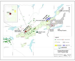
Labrador Uranium Properties in the Central Mineral Belt (Labrador) highlighting the locations of the 2022 Moran Lake Drilling and groundwork.
Figure 2
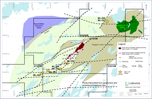
Completed drilling and updated targets for the Moran Lake C Zone with bedrock geology underlay. Geology taken from Crosshair assessment report (Steele, L. and Fox, D, 2012).
Figure 3
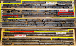
Two zones of typical reddish alteration and uranium mineralization intersected in ML-200. |


