Re <<Outage Wreaks Havoc On World>>
scmp.com
Chinese scientists propose information superhighway between Earth and the moon
Published: 10:00am, 20 Jul 2024

Chinese scientists are working on a proposed communication network to make travel between Earth and the moon easier. Photo: Shutterstock
Chinese scientists have unveiled a road map to build infrastructure between Earth and the moon to meet national strategic needs and make space travel easier and safer for all.
Once complete, the network of 30 satellites and three lunar ground stations would provide real-time communication, navigation and monitoring services to global users, according to researchers from the China Academy of Space Technology (CAST) and the Beijing Institute of Spacecraft System Engineering.
The goal is to enable 20 or more travellers to simultaneously communicate with Earth via images, audio or video. It would also provide relatively accurate positioning, navigation and timing (PNT) during Earth-moon flights and lunar surface operations.
In addition, it would be able to monitor and track moving targets as small as one metre (3.28 feet) in the region between the Earth and the moon, known as cislunar space, the researchers wrote in the journal Chinese Space Science and Technology in June.
“Cislunar space has become a new frontier for human activities,” wrote the team led by Yang Mengfei, chief designer of China’s Chang’e-5 mission.
“Space activities in this region are set to expand rapidly over the next decade, driving a new round of global competition.
“The competition for resources such as orbital slots and radio frequencies is already on, and will only get more intense in the future. There’s an urgent need for China to establish a top-level road map to develop cislunar space infrastructure and gain a competitive edge in the emerging cislunar economy.”
Cislunar space refers to the region of space that lies between – and is influenced by – Earth and the moon. It comprises the orbits of satellitesaround Earth, the space occupied by the moon’s orbit and the space in between.
The concept of cislunar space has become increasingly relevant in recent years, especially for the military sector.
For instance, the United States Air Force is developing a satellite known as the Cislunar Highway Patrol System to demonstrate its ability to detect, track and identify artificial objects at lunar distances (437,000km or 272,000 miles), which is more than a tenfold increase from the traditional geostationary detection range (35,785km or 22,236 miles).
Civil space agencies in the US, Europe and Japan have also proposed similar infrastructure to support scientific exploration and commercial operations at the moon.
As China becomes a major player in lunar and deep space exploration, strategic planning is critical to “avoid repetitive construction and optimise resource allocation” for future missions, the researchers wrote. This includes crewed lunar landings, the construction of an international lunar research station and exploration missions to the outer solar system.
“While plans exist in the US, Europe and Japan, none have been implemented yet. China has a unique opportunity to secure a substantial share in the emerging cislunar space industry,” they wrote.
The three stages of developing cislunar infrastructure proposed by Chinese researchers. Photo: Handout
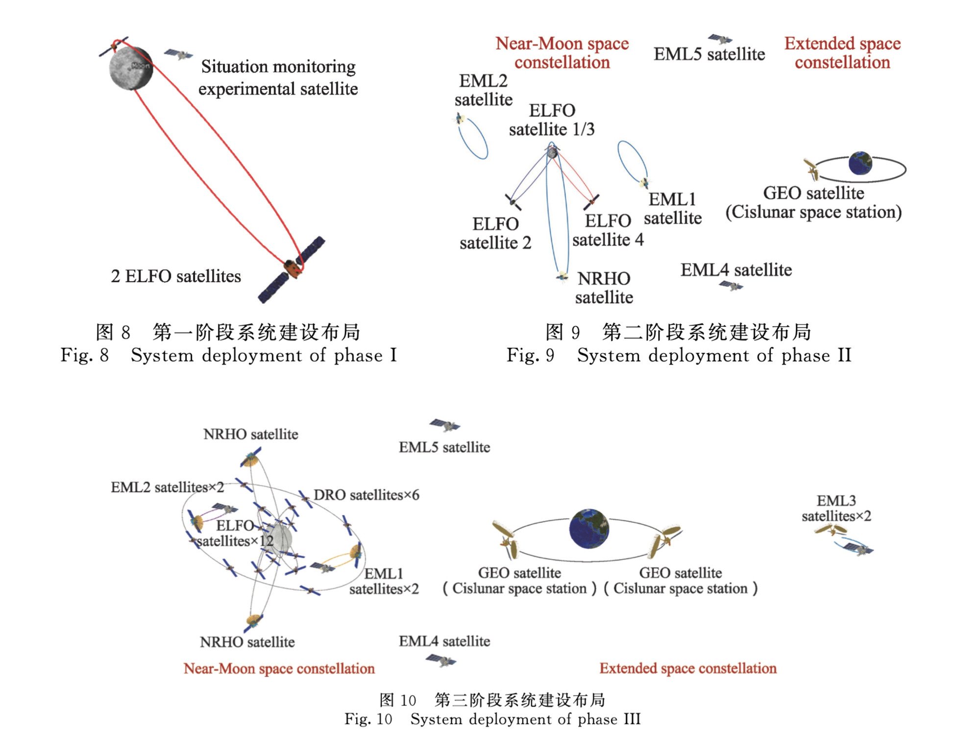
According to Yang and his colleagues, China’s construction of its cislunar infrastructure would unfold in three stages.
The first stage would focus on supporting the country’s robotic and crewed moon missions. By placing a pair of satellites in elliptical lunar orbits and a control station on the lunar surface, it would facilitate communication with the moon’s south pole region for at least 10 users simultaneously.
The second stage would then expand the system to include 10 satellites orbiting the moon, Earth and specific locations known as Earth-moon Lagrange points. A second lunar ground station would improve data transmission rates to 5 gigabytes per second and improve navigation accuracy to 100 metres for the lunar south pole region.
During this stage, anticipated technological breakthroughs would help in identifying non-cooperative targets over long distances, including moving objects with a diameter of 10 metres (32 feet) in near-moon space, according to the paper.
The third and final stage would integrate a comprehensive network of 30 satellites, three lunar ground stations, as well as existing Earth-based communication and navigation facilities. It would aim to achieve data transmission rates of 10 gigabytes per second and enhance navigation accuracies to 10 metres (32 feet) for lunar surface activities and 50 metres (164 feet) for journeys between Earth and the moon.
The proposed network would also deploy a Very Long Baseline Interferometry system to track spacecraft across distances up to 900 million kilometres (559 million miles) with sub-kilometre accuracy, supporting deep space missions to Jupiter and beyond.
“The development of cislunar infrastructure must follow principles of phased development and dynamic expansion,” the researchers stressed.
“It should also consider the needs for international compatibility and cooperation to support China’s aspirations as a space power and nurture new aerospace industries in the country,” they wrote.
Ling Xin
Ling Xin is a science journalist based in Ohio. She mainly covers physics, astronomy and space. Her writing has appeared in Science, Scientific American, MIT Technology Review and other English and Chinese outlets. She was a visiting journalist at Science magazine in Washington, and has a master's degree in journalism from Ohio University.
Chinese scientists have proposed a satellite navigation system to give around-the-clock services to all parts of the moon. Photo: Shutterstock
A BeiDou-like satnav system for the moon? Chinese scientists plot a possible route
The moon could soon have its own satellite navigation system, according to a proposal by Chinese scientists.
The team from the Beijing Institute of Spacecraft System Engineering proposed the construction of 21 satellites around the moon which would provide real-time, high-precision navigation to support China’s lunar ambitions.
The satellites will be deployed in four types of orbits over three phases, featuring a sustainable and cost-effective design, according to a paper published last month in the journal, Chinese Space Science and Technology.
While the paper did not specify a construction timeline, China aims to put astronauts on the moon by 2030 and to build a research base at the lunar south pole with international partners around 2035.
“A satellite constellation in near-lunar space can provide real-time, high-precision navigation and positioning for lunar surface movement, landing and take-off, and support high-frequency human exploration of the moon in the long run,” wrote the team led by Peng Jing, deputy chief designer of China’s Chang’e-5 mission.
“Our study presented a road map to assemble such a constellation step by step, expanding its coverage from the lunar south pole region to the entire moon.”
On Earth, global navigation satellite systems such as the United States’ GPS and China’s BeiDou are in wide use, making it easier to find locations and plan routes.
Read key economic stories from China, including the US-China trade war, sanctions, and economic developments.
Such systems usually comprise 20 to 35 satellites and have an accuracy of a few metres. Each satellite beams off radio signals, allowing the user to determine their location and time using a combination of signals from at least four satellites.
In the study, Peng and his team assessed three major factors of a lunar navigation system: the “quadruple coverage” of having signals from at least four satellites at any given time, the navigation precision, and the construction and maintenance costs.
They found that during the first phase of construction, just placing two satellites in a highly elliptical, extremely stable orbit would guarantee full-time communication between Earth and the moon’s south pole region, with minimal use of fuel for station-keeping once they reach orbit.

In the second phase, by adding nine satellites and two orbit types, the constellation could provide full-time navigation for the lunar south pole region and support around-the-clock communication between Earth and any place on the moon.
In the final phase, placing a total of 21 satellites in four types of orbits, the complete constellation could give relatively accurate positioning for any place on the lunar surface for more than 70 per cent of the time.
The team planned to optimise the parameters of each orbit type and develop a more systematic design for the lunar navigation constellation, the researchers wrote.
China has developed and deployed two communications relay satellites, Queqiao-1 and Queqiao-2, in near-lunar space to support its historic missions to explore the far side of the moon in recent years.
The US, Europe and Japan have also announced plans to develop moon-based navigation constellations.
One such plan is Japan’s Lunar Navigation Satellite System, proposed in 2022. It will consist of eight satellites circling the moon in highly elliptical orbits, providing communication, positioning and navigation services for the lunar south pole region. |


