Fireweed Intersects 30 m True Width of 33.2% Zinc Equivalent in 115 m Step-Out at Tom South
fireweedmetals.com Facebook
Twitter Linkedin
Vancouver, British Columbia: Fireweed Metals Corp. (“Fireweed” or the “Company”) (TSXV: FWZ; OTCQX: FWEDF) is pleased to report the results of the first drill holes from the Tom deposit that intersected high-grade zinc-lead-silver (“Zn-Pb-Ag”) mineralization as part of the 2025 drill campaign at its Macpass Project (“Macpass”), Yukon, Canada.
Highlights
- A major 115 m step-out down-dip at Tom South significantly extending the zone of high-grade massive sulfide mineralization
- Hole TS25-001D1: 30 m true width of 33.23% zinc equivalent1 (“ZnEq”) (54.82 m intersected width of18.20% Zn, 13.93% Pb, and 161.0 g/t Ag), from 891.6 metres (“m”) downhole, including:
- 22 m true width of 41.69% ZnEq (40.43 m intersected width of 22.45% Zn, 17.76% Pb, and 208.16 g/t Ag), including:
- 7.0 m true width of 59.60% ZnEq (12.83 m intersected width of 24.98% Zn, 32.09% Pb, and 371.4 g/t Ag); and,
- 3.9 m true width of 47.33% ZnEq (7.10 m intersected width of 32.82% Zn, 14.28% Pb, and 131.1 g/t Ag).
- Alongside the critical mineral zinc, significant concentrations of other critical minerals, germanium and gallium occur with the zinc mineralization (included within the full results in Table 1).
CEO Statement
Ian Gibbs, President and CEO, stated, “After following up on an isolated historical intersection in 2023, the zone at Tom South has rapidly grown into one of the most prospective areas at Macpass for high-grade step-outs in massive sulphide mineralization. The impressive width and grade of the intersection at Tom South demonstrates that the zone thickens and remains open down-dip, positioning this hole amongst the most significant in the project’s history. Continued success in intersecting massive sulphide mineralization in wide step-outs reinforces Tom’s potential for substantial high-grade resource growth, a major value driver at Macpass, and underscores the massive exploration potential across the district. Additional drilling is planned, aimed at defining the extent of this highly prospective high-grade zone.”
Tom South Results
The Tom South zone is part of the Mineral Resource at the Tom Deposit2. The intersection in hole TS25-001D1 at Tom South described here was a ~115 m step-out down-dip from previous intersections in the Tom South feeder zone and encountered a thick sequence of laminated to massive sulphides consisting of sphalerite, galena, and minor chalcopyrite. This step-out intersection extends well beyond the limits of the 2024 Mineral Resource2 and shows that the Tom South zone maintains remarkable thickness and high-grades in the down-dip direction, where it is open at depth. Tom South is also interpreted as being open in the up-dip direction, where additional drilling is planned.
- TS25-001D1 intersected 30 m true width (54.82 m intersected) of laminated and massive sulphide mineralization, a 115 m step-out, grading 33.23% ZnEq (18.20% zinc, 13.93% lead, and 161.0 g/t silver), including:
- 22 m true width (40.43 m intersected) of 41.69% ZnEq (22.45% Zn, 17.76% Pb, and 208.16 g/t Ag), including:
- 7.0 m true width (12.83 m intersected) of 59.60% ZnEq (24.98% Zn, 32.09% Pb, and 371.4 g/t Ag), and
- 3.9 m true width (7.10 m intersected) of 47.33% ZnEq (32.82% Zn, 14.28% Pb, and 131.1 g/t Ag).
These results, along with the 2024 drilling results from Tom South (see Fireweed News Release dated November 28, 2024) were not included in the 2024 Mineral Resource Estimate as the drilling occurred after the database cut-off date for the 2024 MRE. The wide and high-grade intersections drilled at Tom South since the 2024 MRE show significant potential for expansion of the Tom Mineral Resource.
TS25-001 was abandoned due to challenging drilling conditions and cut off as TS25-001D1 in competent ground to successfully complete the hole.
Tom West Results
Drilling at Tom West provided a test of a gravity anomaly below the Tom deposit and doubled as a successful infill hole within an inferred portion of the Mineral Resource intersecting stratiform zinc and lead mineralization. No new mineralization was encountered below the Tom West zone and a refined interpretation of the density anomaly at Tom West is required to provide an explanation for the observed gravity signal. The infill section of the hole returned a wider and higher-grade intersection than predicted by the geological model used in the 2024 Mineral Resource.
TS25-002D1 was a twin of TS25-002 and was drilled due to poor recovery in the parent hole through the mineralized zone. Recovery in the redrill was an average of 95% in the redrilled intersection.
- TS25-002 intersected 80 m true width (84.69 m intersected) of laminated sulphide mineralization grading 5.45% ZnEq (5.24% Zinc, 0.23% lead, and 1.2 g/t silver), including:
- 14 m true width (14.34 m intersected) of 9.06% ZnEq (8.86% zinc, 0.23% lead, and 0.9 g/t silver).
- TS25-002D1 intersected 83 m true width (87.50 m intersected) of laminated sulphide mineralization grading 5.75% ZnEq (5.55% Zinc, 0.21% lead, and 1.6 g/t silver), including:
- 8.4 m true width (8.87 m intersected) of 9.01% ZnEq (8.80% zinc, 0.23% lead, and 1.3 g/t silver); and,
- 18 m true width (19.50 m intersected) 9.10% ZnEq (8.85% zinc, 0.27% lead, and 1.8 g/t silver).
See Tables 1 and 2, Cross Sections TH–TH’, TD–TD’, Long Section TG–?TG’ and Map 2 below for further details.
Drill Program Update
Fireweed mobilized an additional drill rig to the Macpass District, bringing the total to six rigs at the peak of the season, utilizing three active drill camps with a total capacity of ~150 people.
The drill program at Mactung has been completed, with ~11,300 m drilled at Mactung over the course of the 2025 season. The work at Mactung focused on infill, geotechnical, hydrogeological, and geometallurgical drilling to gather the samples and data necessary to commence a Feasibility Study by the end of this year.
The Macpass drill program also tested several zinc and gold regional exploration targets, and two drill rigs are still operating, targeting additional high-grade step-outs at the Tom deposit. The regional exploration program has been completed and consisted of ground gravity surveys, soil sampling, rock sampling, and prospecting.
Drilling at the Gayna project has been completed.
Samples from all completed drilling and regional programs have been submitted for laboratory analysis and results will continue to be reported when received and interpreted.
Qualified Person Statement
Technical information in this news release has been reviewed and approved by Fireweed Metals Senior Geologist, Ian Carr, P.Geo. (BC), a ‘Qualified Person’ as defined under Canadian National Instrument 43-101 (“NI 43-101?). Mr. Carr is not independent of the Company in accordance with NI 43-101.
About Fireweed
Fireweed is an exploration company focused on unlocking value in a new critical metals district located in Northern Canada. Fireweed is 100% owner of the Macpass District, a large and highly prospective 985 km2 land package. The Macpass District includes the Macpass zinc-lead-silver project and the Mactung tungsten project. A Lundin Group company, Fireweed is strongly positioned to create meaningful value.
Fireweed trades on the TSX Venture Exchange under the trading symbol “FWZ”, on the OTCQX Best Market under the trading symbol “FWEDF”, and on the Frankfurt Stock Exchange under the trading symbol “M0G”.
Additional information about Fireweed and its projects can be found on the Company’s website at FireweedMetals.com and at www.sedarplus.com
ON BEHALF OF FIREWEED METALS CORP.
“Ian Gibbs”
CEO & Director
Neither the TSX Venture Exchange nor its Regulation Services Provider (as that term is defined in the policies of the TSX Venture Exchange) accepts responsibility for the adequacy or accuracy of this release.
Data Verification
The diamond drill core logging and sampling program was carried out under a rigorous quality assurance / quality control program using industry best practices. Drill intersections in this release are NQ2 size (50.5 mm/ 1.99-inch diameter) and HQ size (63.5 mm/ 2.50-inch diameter) with recoveries typically above 85% unless otherwise noted in the results tables. After drilling, core was cleaned, logged for geology, structure, and geotechnical characteristics, then marked for sampling and photographed on site. Certain cores were selected for core scanning using light detection and ranging (LiDAR), short-wave infrared (SWIR), X-ray fluorescence (XRF), and high resolution RGB image capture. The cores for analyses were marked for sampling based on geological intervals with individual samples two metres or less in length, with one metre samples within mineralized zones. Drill core was cut lengthwise in half with a core saw; half-core was sent for assays reported in this news release, and the other half is stored on site for reference. Bulk density was determined on site for the entire length of each assay sample by measurement of mass in air and mass in water. Sample duplicate bulk density determinations and in-house bulk density standard determinations were each made at a rate of 5%. Since 2017, four in-house bulk density standards (mineralized drill core from the Tom deposit that span a range of densities) have been used and show an acceptable long-term precision. Certified standard masses are used to calibrate the scale balance used for bulk density determinations.
A total of 5% assay standards or blanks and 5% core duplicates are included in the sample stream as a quality control measure and are reviewed after analyses are received. Standards and blanks in 2025 drill results to date have been approved as acceptable. Duplicate data add to the long-term estimates of precision for assay data on the project and precision for drill results reported is deemed to be within acceptable levels. Samples were sent to the Bureau Veritas (BV) preparation laboratory in Whitehorse, Yukon, where the samples were crushed and a 500 g split was sent to the BV laboratory in Vancouver, B.C to be pulverized to 85% passing 200 mesh size pulps. Clean crush material was passed through the crusher and clean silica was pulverized between each sample. The pulps were analyzed by 1:1:1 Aqua Regia digestion followed by Inductively Coupled Plasma Mass Spectrometry (ICP-ES/ICP-MS) multi-element analyses (BV Code AQ270). Samples that contained greater than or equal to 1,500 ppm Zn were further analyzed for gallium and germanium using hydrofluoric acid (HF) + aqua regia closed vessel digestion and ICP-MS finish (BV Code GC204). All samples were also analyzed for multiple elements by lithium borate fusion and X-ray fluorescence analysis (XRF) finish (BV Code LF725). Over-limit lead (>25.0%) and zinc (>24.0%) were analyzed by lithium borate fusion with XRF finish (BV Code LF726). Silver is reported in this news release by method AQ270, zinc and lead are reported by LF725 or LF726, and gallium and germanium are reported by GC204. Bureau Veritas (Vancouver) is an independent, international ISO/IEC 17025:2017 accredited laboratory.
Assay values may appear rounded to one decimal place but are given in full in Table 1, and Cross Sections where zinc and lead grades are reported to two decimal places.
Results in this news release are length and bulk-density weighted averages as would be used in a Mineral Resource estimate. Length and bulk-density weighted averages have been reported as these most accurately represent the average metal-content of the intersections.
True widths for primary intervals are estimated by measuring perpendicular to strike within the short axis of a stratiform wireframe that has been constructed in 3D around the mineralized intercepts at Tom based on assay results, geological logging, stratigraphic correlation, and bedding measurements from oriented core. The massive sulphide mineralization and laminated mineralization at Tom are stratiform (oriented parallel to bedding), therefore the true width, or thickness, of the zone is estimated perpendicular to both the strike and dip direction of bedding. True widths are rounded to the nearest metre for widths over 10 m and to the nearest 0.1 m for widths less than 10 m, as this better reflects the precision of the estimates. True widths should be regarded as approximate as these are derived from an estimation that uses a preliminary interpretation of the geological model. True widths for nested intervals (marked as “Including” in results tables) are estimated using a ratio of included to primary intersected widths to attribute appropriate portions of the true width of the primary interval to the nested intervals.
Cautionary Statements
Forward Looking Statements
This news release contains “forward-looking” statements and information (“forward-looking statements”). All statements, other than statements of historical facts, included herein, including, without limitation, statements relating to interpretation of drill results, targets for exploration, potential extensions of mineralized zones, and the potential of the Company’s projects, are forward looking statements. Forward-looking statements are frequently, but not always, identified by words such as “expects”, “anticipates”, “believes”, “intends”, “estimates”, “potential”, “possible”, and similar expressions, or statements that events, conditions, or results “will”, “may”, “could”, or “should” occur or be achieved. Forward-looking statements are based on the beliefs of Company management, as well as assumptions made by and information currently available to Company management and reflect the beliefs, opinions, and projections on the date the statements are made. Forward-looking statements involve various risks and uncertainties and accordingly, readers are advised not to place undue reliance on forward-looking statements. There can be no assurance that such statements will prove to be accurate, and actual results and future events could differ materially from those anticipated in such statements. Important factors that could cause actual results to differ materially from the Company’s expectations include but are not limited to, exploration and development risks, unanticipated reclamation expenses, expenditure and financing requirements, general economic conditions, changes in financial markets, the ability to properly and efficiently staff the Company’s operations, the sufficiency of working capital and funding for continued operations, title matters, First Nations relations, operating hazards, political and economic factors, competitive factors, metal prices, relationships with vendors and strategic partners, governmental regulations and oversight, permitting, seasonality and weather, technological change, industry practices, uncertainties involved in the interpretation of drilling results and laboratory tests, and one-time events. The Company assumes no obligation to update forward-looking statements or beliefs, opinions, projections or other factors, except as required by law.
Footnotes and References
1: Zinc equivalent calculations assume metal prices of US$1.40/lb zinc, US$1.10/lb lead, and US$25/oz silver, zinc concentrate recoveries of 89% Zn, 22% Ag, lead concentrate recoveries of 75% Pb, 59% Ag, 0% payability of Ag in zinc concentrate, 85% payability of Zn in zinc concentrate, 94% payability of Ag in lead concentrate, and 95% payability of Pb in lead concentrate. Germanium and gallium were not included in zinc equivalency calculations. The zinc equivalency formula used is: ZnEq% = ((0.56*Ag g/t)+(16.52*Pb%)+(21.32*Zn%))/21.32. The assumptions used in this zinc equivalency calculation are the same as the assumptions used for zinc equivalency in the 2024 Mineral Resource Estimate2.
2: For Tom, Jason, End Zone, and Boundary Zone Mineral Resources, see the technical report entitled “Technical Report for NI 43-101, Macpass Project, Yukon, Canada” with effective date September 4th, 2024 filed on Sedar+ here Pierre Landry, P.Geo. is independent of Fireweed Metals Corp., and a ‘Qualified Person’ as defined under Canadian National Instrument 43-101. Pierre Landry, of SLR, is responsible for the Tom, Jason, End Zone, and Boundary Zone Mineral Resource Estimates.
Contact: Alex Campbell
Phone: +1 (604) 689-7842
Email: info@fireweedmetals.com
 Map 1: Macpass Project and Mactung Project locations Map 1: Macpass Project and Mactung Project locations 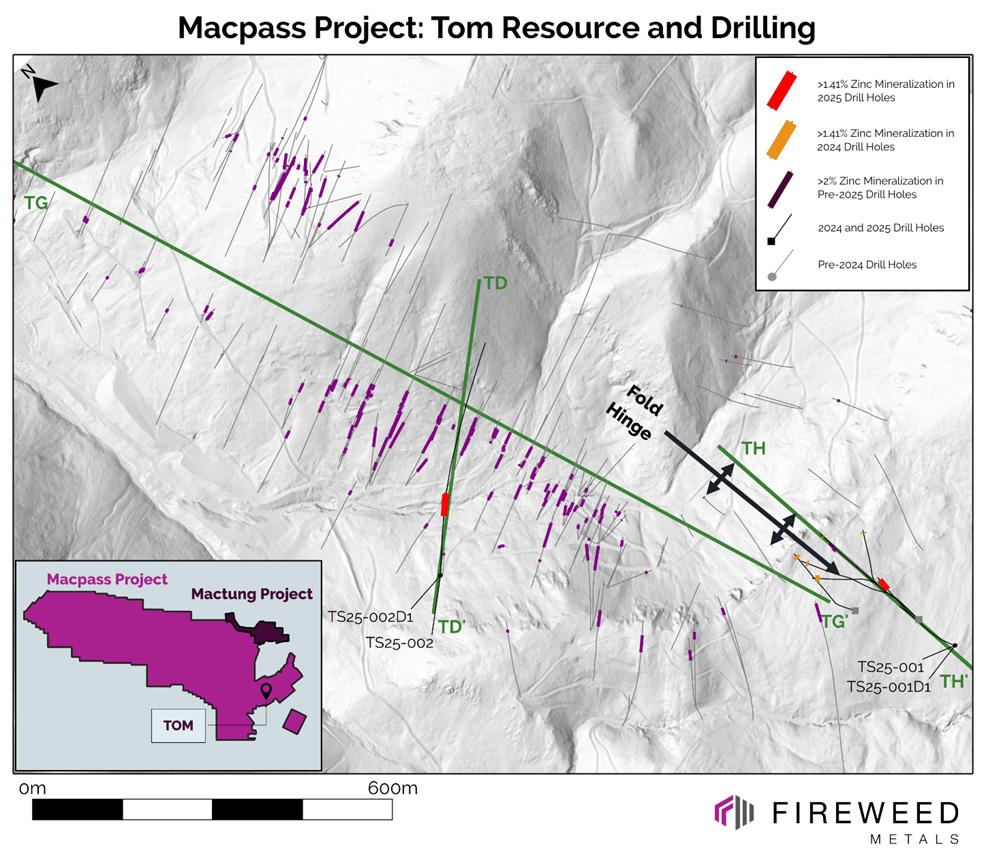 Map 2: Tom composite intervals in 2025 drilling, 2024 drilling and pre-2024 drilling Map 2: Tom composite intervals in 2025 drilling, 2024 drilling and pre-2024 drilling 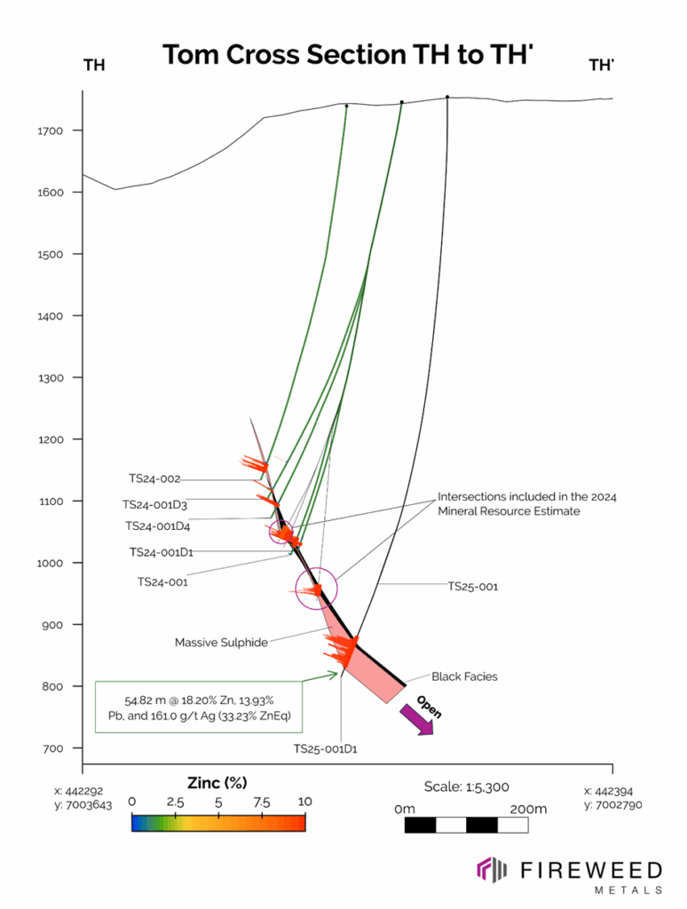 Cross section TH to TH’: Tom South 2025 holes TS25-001 and TS25-001D1 and 2024 holes that were not included in the 2024 Mineral Resource Estimate. Cross section TH to TH’: Tom South 2025 holes TS25-001 and TS25-001D1 and 2024 holes that were not included in the 2024 Mineral Resource Estimate.
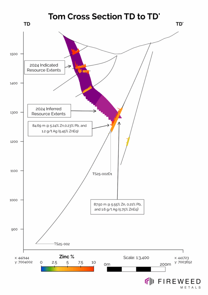 Cross section TH to TH’: TS25-002 and TS25-002D1 Cross section TH to TH’: TS25-002 and TS25-002D1
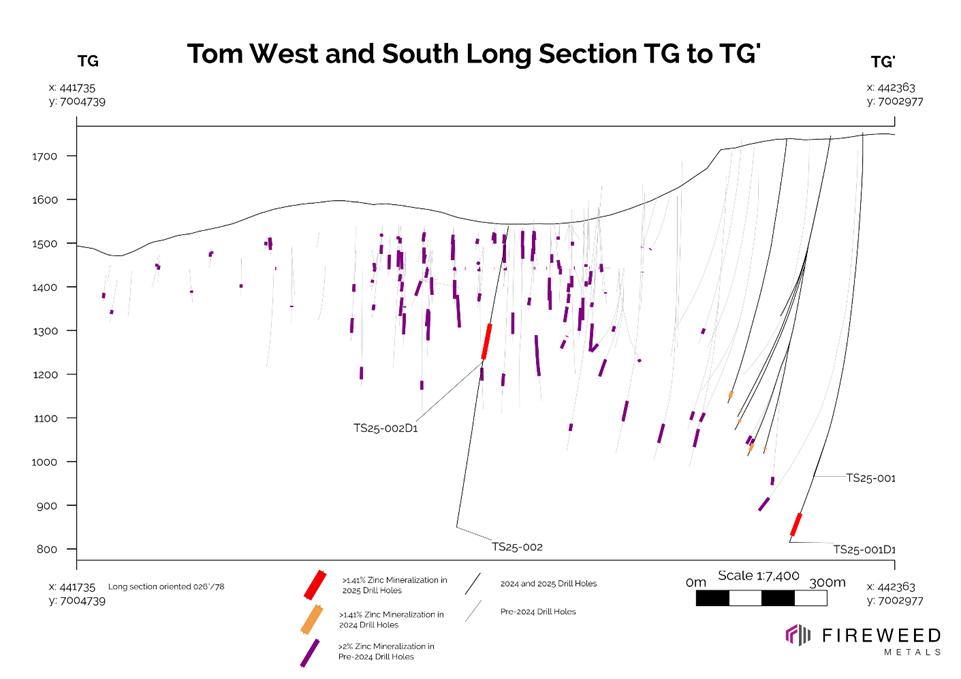 Inclined Long section TG to TG’: showing 2025, 2024 and pre-2024 drilling Inclined Long section TG to TG’: showing 2025, 2024 and pre-2024 drilling
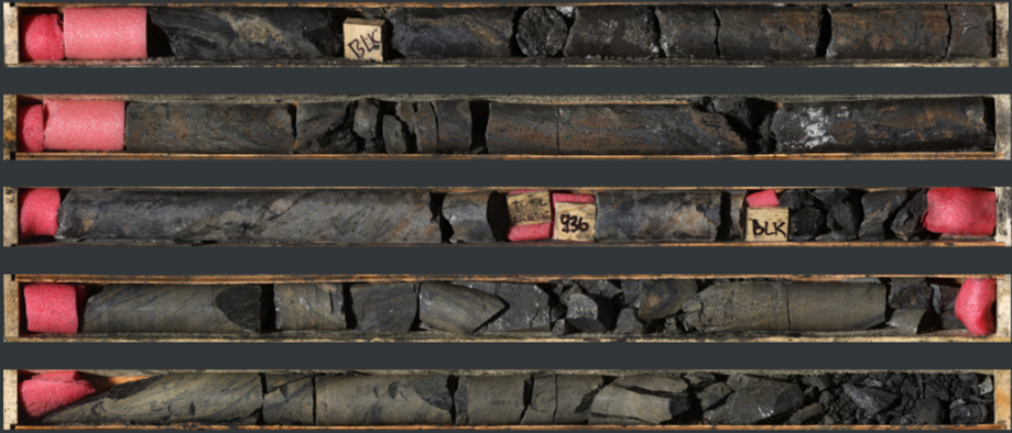 Photo 1: A portion of the intersection in TS25-001D1 containing massive sphalerite and galena from 933.5 to 938.3 m Photo 1: A portion of the intersection in TS25-001D1 containing massive sphalerite and galena from 933.5 to 938.3 m
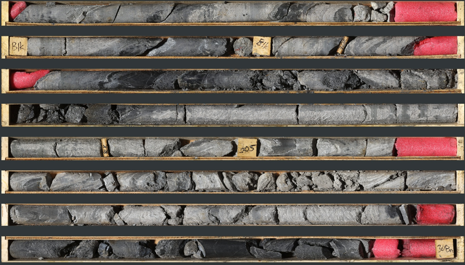 Photo 2: TS25-002D1 300.3 to 308.0 m—grey facies laminated sphalerite and barite. Photo 2: TS25-002D1 300.3 to 308.0 m—grey facies laminated sphalerite and barite.
Table 1: TS25-001, TS25-001D1, TS25-002, and TS25-002D1 drill results
| Drillhole | Interval | From (m) | To (m) | Interval Width (m) | Est. True Width (m) ‡ | Zinc (%) | Lead (%) | Silver (g/t) | Gallium (ppm) | Germanium (ppm) | Bulk Density (t/m3) | Zinc Eq. (%)1 | | TS25-001D1 | Primary* | 891.60 | 946.42 | 54.82 | 30 | 18.20 | 13.93 | 161.0 | 9.31 | 50.94 | 3.28 | 33.23 | | TS25-001D1 | Including* | 893.10 | 943.87 | 50.77 | 28 | 19.47 | 14.88 | 170.9 | 9.57 | 54.34 | 3.30 | 35.49 | | TS25-001D1 | >Including* | 897.98 | 942.60 | 44.62 | 24 | 21.42 | 16.54 | 191.4 | 9.74 | 59.10 | 3.33 | 39.27 | | TS25-001D1 | >>Including* | 902.17 | 942.60 | 40.43 | 22 | 22.45 | 17.76 | 208.2 | 10.06 | 62.38 | 3.37 | 41.69 | | TS25-001D1 | >>>Including* | 902.17 | 915.00 | 12.83 | 7.0 | 24.98 | 32.09 | 371.4 | 11.76 | 66.64 | 3.79 | 59.60 | | TS25-001D1 | >>>Including* | 931.50 | 938.60 | 7.10 | 3.9 | 32.82 | 14.28 | 131.1 | 6.34 | 90.30 | 3.55 | 47.33 | | TS25-002 | primary | 244.85 | 329.54 | 84.69 | 80 | 5.24 | 0.23 | 1.2 | 9.08 | 3.21 | 2.77 | 5.45 | | TS25-002 | Including* | 250.54 | 314.79 | 64.25 | 61 | 6.30 | 0.17 | 1.0 | 8.89 | 3.02 | 2.75 | 6.46 | | TS25-002 | >Including* | 300.36 | 314.79 | 14.43 | 14 | 8.86 | 0.23 | 0.9 | 8.84 | 3.24 | 2.81 | 9.06 | | TS25-002D1 | Primary | 246.00 | 333.50 | 87.50 | 83 | 5.55 | 0.21 | 1.6 | 10.16 | 3.03 | 2.75 | 5.75 | | TS25-002D1 | Including | 251.50 | 315.50 | 64.00 | 60 | 7.02 | 0.21 | 1.5 | 10.24 | 2.83 | 2.73 | 7.22 | | TS25-002D1 | >Including | 272.13 | 281.00 | 8.87 | 8.4 | 8.80 | 0.23 | 1.3 | 13.50 | 2.68 | 2.70 | 9.01 | | TS25-002D1 | >Including | 294.50 | 314.00 | 19.50 | 18 | 8.85 | 0.27 | 1.8 | 9.27 | 3.03 | 2.69 | 9.10 |
‡ See “Data Verification” for a description of true width calculations
* Denotes intersections with recovery below 85%
1 See “Footnotes and References” for Zinc Eq. calculations
Table 2: 2025 Drilling Summary
| Drillhole | Length (m) | Zone | Significant Intersection | Type | | NB25-001 | 62.00 | Boundary Zone | Results Disclosed July 30, 2025 | Step Out | | NB25-002 | 536.30 | Boundary Zone | Results Disclosed July 30, 2025 | Step Out | | NB25-003 | 188.04 | Boundary Zone | Results Disclosed July 30, 2025 | Step Out | | NB25-004 | 242.05 | Boundary Zone | Results Disclosed July 30, 2025 | Step Out | | NB25-005 | 198.05 | Boundary Zone | Results Disclosed July 30, 2025 | Step Out | | NB25-006 | 80.04 | Boundary Zone | Results Disclosed July 30, 2025 | Exploration | | MP25-001 | 206.40 | Target B | Results Disclosed July 30, 2025 | Exploration | | MP25-002 | 354.00 | Steele | none | Exploration | | TS25-001 | 801.05 | Tom South | Abandoned | Step Out | | TS25-001D1 | 963.10 | Exploration | Results disclosed in this release | Step Out | | TS25-002 | 800.05 | Exploration | Results disclosed in this release | Infill | | TS25-002D1 | 340.00 | Exploration | Results disclosed in this release | Infill |
Table 3: Drill Hole Collar Information | Drillhole | Zone | Length (m) | Easting | Northing | Elevation (m.s.l) | Azimuth (°) | Dip (°) | | MP25-001 | Regional | 206.40 | 431663.56 | 7005073.72 | 1258.67 | 205.03 | -51.30 | | MP25-002 | Regional | 354.00 | 409349.00 | 7018979.00 | 1490.00 | 019.92 | -50.30 | | NB25-001 | Boundary | 62.00 | 422469.38 | 7010518.89 | 1193.09 | 025.00 | -70.00 | | NB25-002 | Boundary | 536.30 | 422469.38 | 7010518.89 | 1193.09 | 027.37 | -70.21 | | NB25-003 | Boundary | 188.04 | 422668.21 | 7010230.31 | 1131.81 | 216.10 | -49.58 | | NB25-004 | Boundary | 242.05 | 422656.00 | 7010291.00 | 1140.38 | 215.32 | -49.51 | | NB25-005 | Boundary | 198.05 | 422581.16 | 7010273.67 | 1133.71 | 214.79 | -59.46 | | NB25-006 | Boundary | 80.04 | 421920.28 | 7010301.58 | 1137.44 | 004.83 | -50.01 | | TS25-001 | Tom South | 801.05 | 442371.80 | 7003057.00 | 1753.16 | 179.47 | -89.93 | | TS25-001D1 | Tom South | 963.10 | 442371.80 | 7003057.00 | 1753.16 | 179.47 | -89.93 | | TS25-002 | Tom West | 800.05 | 441812.16 | 7003717.89 | 1536.01 | 047.71 | -68.81 | | TS25-002D1 | Tom West | 340.00 | 441812.16 | 7003717.89 | 1536.01 | 047.71 | -68.81 |
Coordinates listed in NAD83 UTM Zone 9N.
|


